
| Memorials | : | 203 |
| Location | : | Paeroa, Hauraki District, New Zealand |
| Coordinate | : | -37.3900600, 175.6908910 |
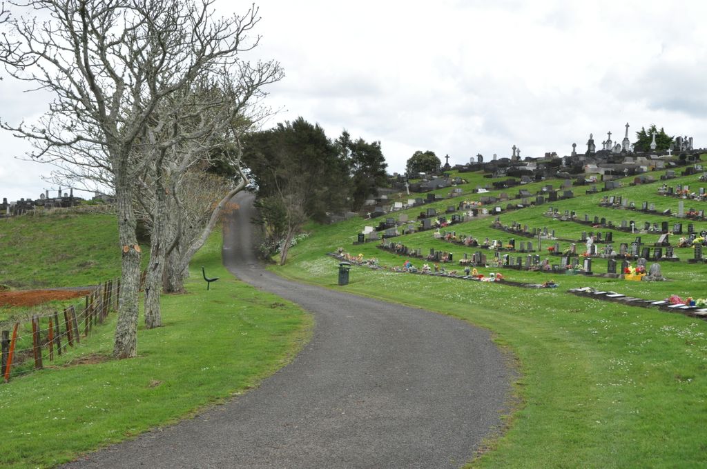
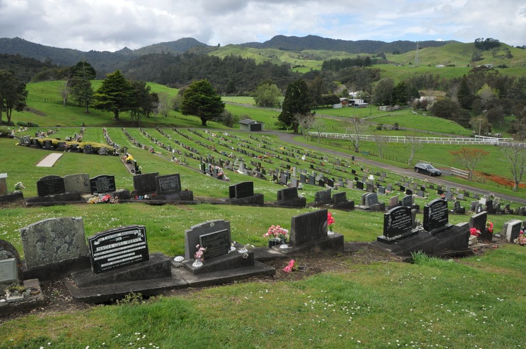
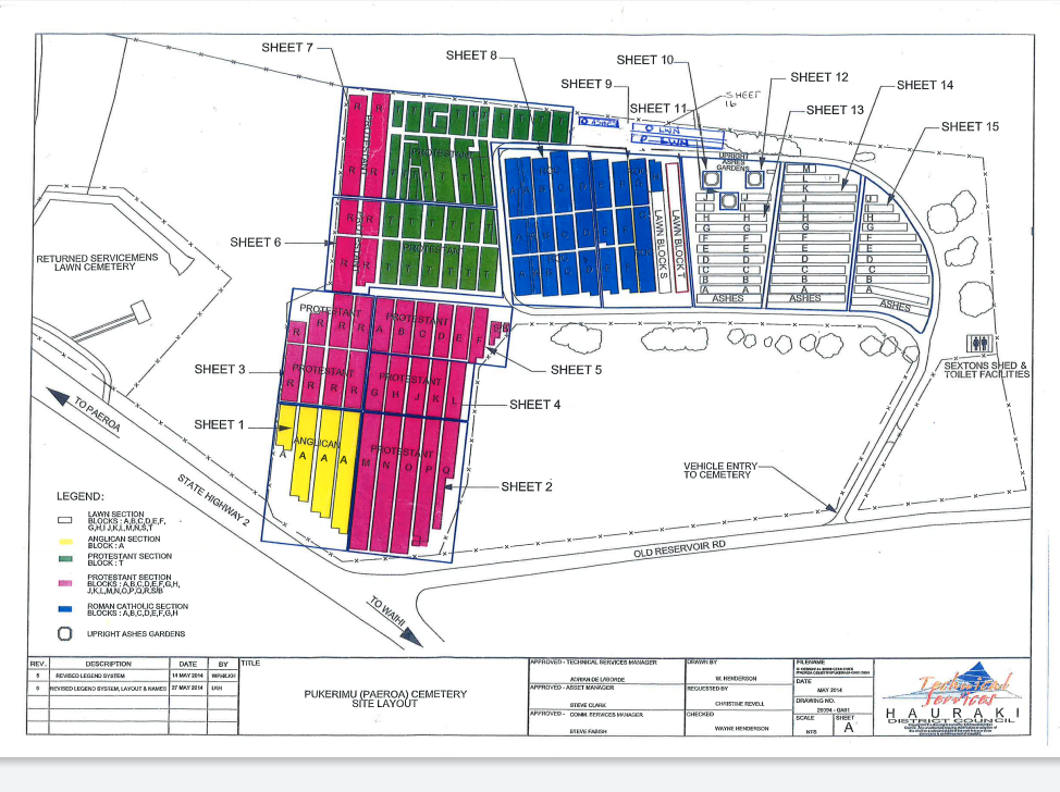
| Description | : | 6.57 hectares of land, situated amongst gently sloping farmland on the main road to Waihi. Established prior to 1885 when the land was owned by the Thames County Council, as the public cemetery for the surrounding rural area including Paeroa. Ownership was subsequently transferred to the Ohinemuri County Council, and then to Hauraki District Council following local government amalgamation in 1989. The Council has delegated administration to the Paeroa Ward Committee. Within the cemetery are sections for Ashes Burials, Burials, and Returned Services Association (RSA) Burials. |
frequently asked questions (FAQ):
-
Where is Pukerimu Lawn Cemetery?
Pukerimu Lawn Cemetery is located at Cnr State Highway 2 and Old Reservoir Road Paeroa, Hauraki District ,Waikato , 3674New Zealand.
-
Pukerimu Lawn Cemetery cemetery's updated grave count on graveviews.com?
202 memorials
-
Where are the coordinates of the Pukerimu Lawn Cemetery?
Latitude: -37.3900600
Longitude: 175.6908910
Nearby Cemetories:
1. Tirohia
Paeroa, Hauraki District, New Zealand
Coordinate: -37.4381503, 175.6436459
2. Omahu Cemetery
Hikutaia, Thames-Coromandel District, New Zealand
Coordinate: -37.2707910, 175.6533300
3. Waihi Cemetery
Waihi, Hauraki District, New Zealand
Coordinate: -37.4093500, 175.8629600
4. Maukoro Cemetery
Morrinsville, Matamata-Piako District, New Zealand
Coordinate: -37.4614130, 175.5018220
5. Te Aroha Cemetery
Te Aroha, Matamata-Piako District, New Zealand
Coordinate: -37.5561450, 175.7109550
6. Ngatea Memorial Walls
Ngatea, Hauraki District, New Zealand
Coordinate: -37.2757990, 175.4915380
7. St Peters by the Sea
Waihi Beach, Western Bay of Plenty District, New Zealand
Coordinate: -37.4012045, 175.9369234
8. Whangamata Cemetery
Whangamata, Thames-Coromandel District, New Zealand
Coordinate: -37.2278330, 175.8553480
9. Tuapiro Cemetery
Katikati, Western Bay of Plenty District, New Zealand
Coordinate: -37.4987630, 175.9234740
10. Faulkner Urupā
Tauranga, Tauranga City, New Zealand
Coordinate: -37.4464650, 175.9540970
11. Totara Memorial Park
Thames, Thames-Coromandel District, New Zealand
Coordinate: -37.1653440, 175.5590990
12. Allan Block Cemetery
Whangamata, Thames-Coromandel District, New Zealand
Coordinate: -37.1794319, 175.8572147
13. Parawai Māori Cemetery
Parawai, Thames-Coromandel District, New Zealand
Coordinate: -37.1590100, 175.5640600
14. Katikati Cemetery
Katikati, Western Bay of Plenty District, New Zealand
Coordinate: -37.5824500, 175.9061600
15. Shortland Cemetery
Thames, Thames-Coromandel District, New Zealand
Coordinate: -37.1423500, 175.5571520
16. Piako Cemetery
Morrinsville, Matamata-Piako District, New Zealand
Coordinate: -37.6484900, 175.5412240
17. Morrinsville Old Cemetery
Morrinsville, Matamata-Piako District, New Zealand
Coordinate: -37.6531500, 175.5374260
18. Tararu Cemetery
Thames, Thames-Coromandel District, New Zealand
Coordinate: -37.1049590, 175.5189510
19. Makomako Urupā
Waitakaruru, Hauraki District, New Zealand
Coordinate: -37.2329470, 175.3389910
20. Waiterimu-Matahuru Cemetery
Waiterimu, Waikato District, New Zealand
Coordinate: -37.4452080, 175.2910660
21. Kaimai Flight 441 Air Crash Memorial
Gordon, Matamata-Piako District, New Zealand
Coordinate: -37.6960470, 175.8260440
22. Rukumoana Urupā
Matamata, Matamata-Piako District, New Zealand
Coordinate: -37.6976740, 175.5572500
23. Orini Cemetery
Orini, Waikato District, New Zealand
Coordinate: -37.5535200, 175.3222100
24. Waerenga Cemetery
Waerenga, Waikato District, New Zealand
Coordinate: -37.3650160, 175.2398320