
| Memorials | : | 0 |
| Location | : | Ngatea, Hauraki District, New Zealand |
| Coordinate | : | -37.2757990, 175.4915380 |
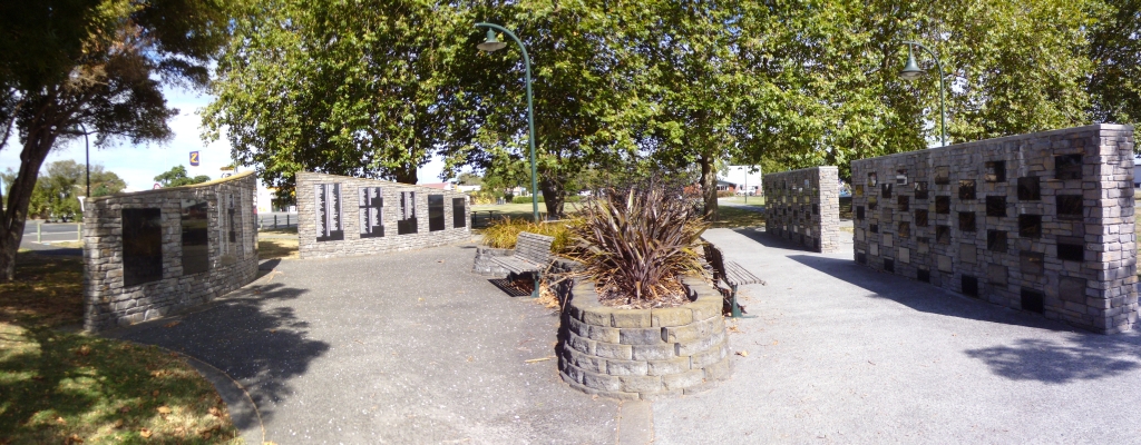
| Description | : | NGATEA ASHES WALL Due to the unsuitable ground conditions of the Hauraki Plains the Council have been unable to provide a central cemetery for the Plains Community. Two 80 vault purpose built walls for the accommodation of ashes have been constructed as part of the Hugh Hayward Domain Settlers Park development, Orchard Road, Ngatea. NGATEA - HAURAKI PLAINS MEMORIAL WALL Comprising two large curved stone walls with granite plaques, is situated within the Hugh Hayward Domain, Orchard Road, Ngatea. Due to the unsuitable ground conditions of the Hauraki Plains the Council have been unable to provide a central cemetery for the Plains Community. In 2003 Council... Read More |
frequently asked questions (FAQ):
-
Where is Ngatea Memorial Walls?
Ngatea Memorial Walls is located at Ngatea, Hauraki District ,Waikato ,New Zealand.
-
Ngatea Memorial Walls cemetery's updated grave count on graveviews.com?
0 memorials
-
Where are the coordinates of the Ngatea Memorial Walls?
Latitude: -37.2757990
Longitude: 175.4915380
Nearby Cemetories:
1. Totara Memorial Park
Thames, Thames-Coromandel District, New Zealand
Coordinate: -37.1653440, 175.5590990
2. Makomako Urupā
Waitakaruru, Hauraki District, New Zealand
Coordinate: -37.2329470, 175.3389910
3. Omahu Cemetery
Hikutaia, Thames-Coromandel District, New Zealand
Coordinate: -37.2707910, 175.6533300
4. Parawai Māori Cemetery
Parawai, Thames-Coromandel District, New Zealand
Coordinate: -37.1590100, 175.5640600
5. Shortland Cemetery
Thames, Thames-Coromandel District, New Zealand
Coordinate: -37.1423500, 175.5571520
6. Tararu Cemetery
Thames, Thames-Coromandel District, New Zealand
Coordinate: -37.1049590, 175.5189510
7. Miranda Cemetery
Miranda, Hauraki District, New Zealand
Coordinate: -37.1798970, 175.2980610
8. Maukoro Cemetery
Morrinsville, Matamata-Piako District, New Zealand
Coordinate: -37.4614130, 175.5018220
9. Maramarua Cemetery
Maramarua, Waikato District, New Zealand
Coordinate: -37.2572920, 175.2538630
10. Pukerimu Lawn Cemetery
Paeroa, Hauraki District, New Zealand
Coordinate: -37.3900600, 175.6908910
11. Tirohia
Paeroa, Hauraki District, New Zealand
Coordinate: -37.4381503, 175.6436459
12. Waerenga Cemetery
Waerenga, Waikato District, New Zealand
Coordinate: -37.3650160, 175.2398320
13. Waiterimu-Matahuru Cemetery
Waiterimu, Waikato District, New Zealand
Coordinate: -37.4452080, 175.2910660
14. Whakatiwai Urupā
Auckland Council, New Zealand
Coordinate: -37.0860660, 175.3014660
15. Waiomu Urupā
Thames-Coromandel District, New Zealand
Coordinate: -37.0267530, 175.5194780
16. Whangamata Cemetery
Whangamata, Thames-Coromandel District, New Zealand
Coordinate: -37.2278330, 175.8553480
17. Allan Block Cemetery
Whangamata, Thames-Coromandel District, New Zealand
Coordinate: -37.1794319, 175.8572147
18. Orini Cemetery
Orini, Waikato District, New Zealand
Coordinate: -37.5535200, 175.3222100
19. Waihi Cemetery
Waihi, Hauraki District, New Zealand
Coordinate: -37.4093500, 175.8629600
20. Rangiriri Historic War Cemetery
Rangiriri, Waikato District, New Zealand
Coordinate: -37.4317520, 175.1339760
21. Rangiriri Cemetery
Rangiriri, Waikato District, New Zealand
Coordinate: -37.4251670, 175.1283410
22. Te Aroha Cemetery
Te Aroha, Matamata-Piako District, New Zealand
Coordinate: -37.5561450, 175.7109550
23. Mercer Cemetery
Mercer, Waikato District, New Zealand
Coordinate: -37.2764860, 175.0578300
24. Ashby Cemetery
Manukau, Auckland Council, New Zealand
Coordinate: -36.9756920, 175.2599670