
| Memorials | : | 0 |
| Location | : | Whakatāne, Whakatāne District, New Zealand |
| Website | : | maorimaps.com/marae/pupuaruhe-toroa |
| Coordinate | : | -37.9555600, 176.9624100 |
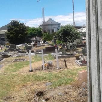
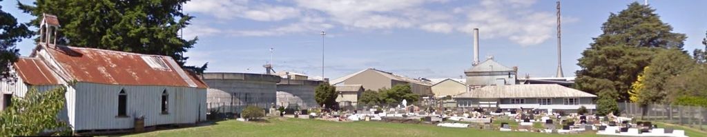
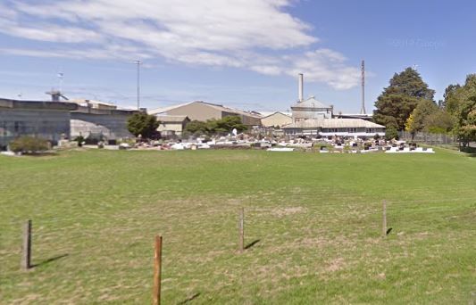
| Description | : | The Church was known as St Andrews, built by Tiaki Rewiri in 1902. Tiaki gifted the land for both the church and the adjacent urupa (Cemetery). The church was later deconsecrated and Tiakis people renamed the church Pupuaruhe after the land it stands on. The church is located behind the Whakatane Board Mills. This place was once a thriving community and has significant cultural value. At one time there was a Give-a-Little page set up to try and get funds together to renovate it, however sadly wasn't successful. A group of locals have a passion and desire to restore the church... Read More |
frequently asked questions (FAQ):
-
Where is Pupuaruhe Urupā?
Pupuaruhe Urupā is located at 95 Mill Road, Coastlands Whakatāne, Whakatāne District ,Bay of Plenty , 3191New Zealand.
-
Pupuaruhe Urupā cemetery's updated grave count on graveviews.com?
0 memorials
-
Where are the coordinates of the Pupuaruhe Urupā?
Latitude: -37.9555600
Longitude: 176.9624100
Nearby Cemetories:
1. Domain Road Cemetery
Whakatāne, Whakatāne District, New Zealand
Coordinate: -37.9583600, 176.9840800
2. Ōpihi Whanaunga Kore Urupā
Whakatāne, Whakatāne District, New Zealand
Coordinate: -37.9436107, 177.0046426
3. Hillcrest Cemetery
Whakatāne, Whakatāne District, New Zealand
Coordinate: -37.9673630, 177.0136840
4. Matariu Urupā
Te Teko, Whakatāne District, New Zealand
Coordinate: -38.0390400, 176.8016400
5. Rangiaohia Māori Cemetery
Matatā, Whakatāne District, New Zealand
Coordinate: -37.8905100, 176.7639600
6. Awakaponga Cemetery
Matatā, Whakatāne District, New Zealand
Coordinate: -37.9308200, 176.7465100
7. Ruatoki North Māori Cemetery
Ruatoki North, Whakatāne District, New Zealand
Coordinate: -38.1501100, 177.0073300
8. Ngahina Māori Cemetery
Ruatoki North, Whakatāne District, New Zealand
Coordinate: -38.1736200, 176.9892600
9. Woodlands Cemetery
Ōpōtiki, Ōpōtiki District, New Zealand
Coordinate: -38.0305569, 177.2635720
10. Old Military Cemetery
Ōpōtiki, Ōpōtiki District, New Zealand
Coordinate: -38.0025964, 177.2851815
11. Ōpōtiki Lawn Cemetery
Ōpōtiki, Ōpōtiki District, New Zealand
Coordinate: -38.0180870, 177.2882760
12. Kawerau Cemetery
Kawerau, Kawerau District, New Zealand
Coordinate: -38.0990990, 176.6762150
13. Opape Urupā
Ōpōtiki, Ōpōtiki District, New Zealand
Coordinate: -37.9746540, 177.4244230
14. Punawhakareia Urupa
Rotoiti, Rotorua District, New Zealand
Coordinate: -38.0566969, 176.4451150
15. Ngāti Tarāwhai Ruatō urupa
Rotoiti, Rotorua District, New Zealand
Coordinate: -38.0578310, 176.4334750
16. St. Thomas's Anglican Churchyard
Maketu, Western Bay of Plenty District, New Zealand
Coordinate: -37.7600849, 176.4555692
17. Maketu Cemetery
Maketu, Western Bay of Plenty District, New Zealand
Coordinate: -37.7634700, 176.4511500
18. White Island Burial Site
Whakatāne District, New Zealand
Coordinate: -37.5241910, 177.1863520
19. Okere Māori Cemetery
Okere Falls, Rotorua District, New Zealand
Coordinate: -38.0332900, 176.3464800
20. Maraenui Māori Cemetery
Houpoto, Ōpōtiki District, New Zealand
Coordinate: -37.8694900, 177.5849900
21. Motutawa Māori Cemetery
Mourea, Rotorua District, New Zealand
Coordinate: -38.0458300, 176.3381400
22. Te Kahika Māori Cemetery
Te Puke, Western Bay of Plenty District, New Zealand
Coordinate: -37.7884600, 176.3445600
23. Old Te Puke Cemetery
Te Puke, Western Bay of Plenty District, New Zealand
Coordinate: -37.7884910, 176.3354700
24. Murupara-Galatea Cemetery
Galatea, Whakatāne District, New Zealand
Coordinate: -38.4411700, 176.7164800