
| Memorials | : | 1 |
| Location | : | Gambier, Knox County, USA |
| Coordinate | : | 40.3876340, -82.3710770 |
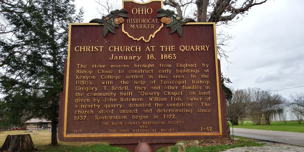
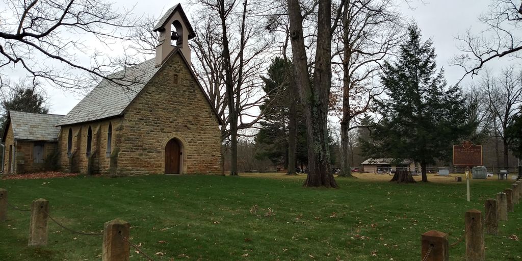
| Description | : | The cemetery is located on the south side of Quarry Chapel Road (Township Road 235) about 200 feet west of its intersection with Monroe Mills Road (Township Road 233). The cemetery is located in College Township, Knox County, Ohio, and is # 6174 (Quarry Cemetery / Stone Quarry Chapel Cemetery) in “Ohio Cemeteries 1803-2003”, compiled by the Ohio Genealogical Society. The cemetery is registered with the Ohio Division of Real Estate and Professional Licensing (ODRE) as Quarry Chapel Cemetery with registration license number CGR.2013004591. The U.S. Geological Survey (USGS) Geographic Names Information System (GNIS) feature ID for the... Read More |
frequently asked questions (FAQ):
-
Where is Quarry Chapel Cemetery?
Quarry Chapel Cemetery is located at Quarry Chapel Road (Township Road 235) Gambier, Knox County ,Ohio , 43022USA.
-
Quarry Chapel Cemetery cemetery's updated grave count on graveviews.com?
1 memorials
-
Where are the coordinates of the Quarry Chapel Cemetery?
Latitude: 40.3876340
Longitude: -82.3710770
Nearby Cemetories:
1. Kokosing Nature Preserve Burial Ground
Gambier, Knox County, USA
Coordinate: 40.3835390, -82.3766900
2. Pleasant Valley Cemetery
Howard, Knox County, USA
Coordinate: 40.4021988, -82.3705978
3. Oak Grove Cemetery
Gambier, Knox County, USA
Coordinate: 40.3838997, -82.3936005
4. Mount Zion Cemetery
Gambier, Knox County, USA
Coordinate: 40.3750000, -82.3518982
5. Kenyon College Cemetery
Gambier, Knox County, USA
Coordinate: 40.3740700, -82.3984400
6. Branstool-Critchfield-Shrimplin Cemetery
Howard, Knox County, USA
Coordinate: 40.4021940, -82.3393400
7. Patterson Cemetery
Mount Vernon, Knox County, USA
Coordinate: 40.4262300, -82.3857190
8. Old Jelloway Cemetery
Howard, Knox County, USA
Coordinate: 40.4240740, -82.3451150
9. Wright Cemetery
Howard, Knox County, USA
Coordinate: 40.4116040, -82.3264590
10. Mount Vernon Memorial Gardens
Mount Vernon, Knox County, USA
Coordinate: 40.4108009, -82.4203033
11. Union Grove Cemetery
Gambier, Knox County, USA
Coordinate: 40.3417000, -82.3585300
12. Hopewell Cemetery
Knox County, USA
Coordinate: 40.3362100, -82.3887500
13. Bostater Family Cemetery
Mount Vernon, Knox County, USA
Coordinate: 40.3605000, -82.4453000
14. Veatch Family Cemetery
Knox County, USA
Coordinate: 40.3221803, -82.3652776
15. Mount Pleasant Cemetery
Knox County, USA
Coordinate: 40.3280983, -82.4139023
16. Saint Johns Cemetery
South Mount Vernon, Knox County, USA
Coordinate: 40.3633003, -82.4618988
17. Millwood Cemetery
Millwood, Knox County, USA
Coordinate: 40.4028015, -82.2746964
18. Skeen Cemetery
Monroe Township, Knox County, USA
Coordinate: 40.4160625, -82.4653704
19. Ebenezer Cemetery
Mount Vernon, Knox County, USA
Coordinate: 40.4486400, -82.4365800
20. Bethel Cemetery
Knox County, USA
Coordinate: 40.3349991, -82.2930984
21. Amity Cemetery
Knox County, USA
Coordinate: 40.4716988, -82.3743973
22. N N A Cemetery
Knox County, USA
Coordinate: 40.3212130, -82.4422550
23. Mound View Cemetery
Mount Vernon, Knox County, USA
Coordinate: 40.4042015, -82.4832993
24. Mount Calvary Cemetery
Mount Vernon, Knox County, USA
Coordinate: 40.4049988, -82.4852982