
| Memorials | : | 5 |
| Location | : | Howard, Knox County, USA |
| Coordinate | : | 40.4021940, -82.3393400 |
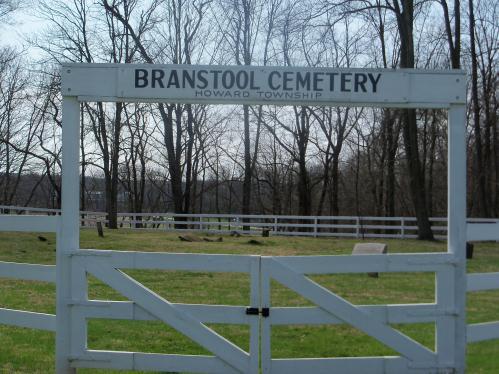
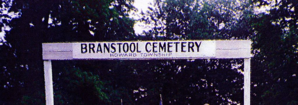
| Description | : | Schenck Road, Howard Township, South of Coshocton Road (36). Off NW side of Schenck Creek Road (County Road 34) just N. of Tish Road on hill at Y in road, N. of bridge. This cemetery is on private property and is being cared for by property owner. You need permission from owner to visit. |
frequently asked questions (FAQ):
-
Where is Branstool-Critchfield-Shrimplin Cemetery?
Branstool-Critchfield-Shrimplin Cemetery is located at Schenck Creek Road Howard, Knox County ,Ohio , 43028USA.
-
Branstool-Critchfield-Shrimplin Cemetery cemetery's updated grave count on graveviews.com?
5 memorials
-
Where are the coordinates of the Branstool-Critchfield-Shrimplin Cemetery?
Latitude: 40.4021940
Longitude: -82.3393400
Nearby Cemetories:
1. Wright Cemetery
Howard, Knox County, USA
Coordinate: 40.4116040, -82.3264590
2. Old Jelloway Cemetery
Howard, Knox County, USA
Coordinate: 40.4240740, -82.3451150
3. Pleasant Valley Cemetery
Howard, Knox County, USA
Coordinate: 40.4021988, -82.3705978
4. Quarry Chapel Cemetery
Gambier, Knox County, USA
Coordinate: 40.3876340, -82.3710770
5. Mount Zion Cemetery
Gambier, Knox County, USA
Coordinate: 40.3750000, -82.3518982
6. Kokosing Nature Preserve Burial Ground
Gambier, Knox County, USA
Coordinate: 40.3835390, -82.3766900
7. Patterson Cemetery
Mount Vernon, Knox County, USA
Coordinate: 40.4262300, -82.3857190
8. Oak Grove Cemetery
Gambier, Knox County, USA
Coordinate: 40.3838997, -82.3936005
9. Millwood Cemetery
Millwood, Knox County, USA
Coordinate: 40.4028015, -82.2746964
10. Kenyon College Cemetery
Gambier, Knox County, USA
Coordinate: 40.3740700, -82.3984400
11. Union Grove Cemetery
Gambier, Knox County, USA
Coordinate: 40.3417000, -82.3585300
12. Mount Vernon Memorial Gardens
Mount Vernon, Knox County, USA
Coordinate: 40.4108009, -82.4203033
13. Saint Luke Cemetery
Danville, Knox County, USA
Coordinate: 40.4468994, -82.2786026
14. Workman Cemetery
Danville, Knox County, USA
Coordinate: 40.4361000, -82.2636032
15. Hollister Cemetery
Knox County, USA
Coordinate: 40.3830986, -82.2485962
16. Amity Cemetery
Knox County, USA
Coordinate: 40.4716988, -82.3743973
17. Bethel Cemetery
Knox County, USA
Coordinate: 40.3349991, -82.2930984
18. Hopewell Cemetery
Knox County, USA
Coordinate: 40.3362100, -82.3887500
19. McKee Cemetery
Danville, Knox County, USA
Coordinate: 40.4306204, -82.2443237
20. Veatch Family Cemetery
Knox County, USA
Coordinate: 40.3221803, -82.3652776
21. Campbell Cemetery
Knox County, USA
Coordinate: 40.3403015, -82.2636032
22. Ebenezer Cemetery
Mount Vernon, Knox County, USA
Coordinate: 40.4486400, -82.4365800
23. Bostater Family Cemetery
Mount Vernon, Knox County, USA
Coordinate: 40.3605000, -82.4453000
24. Banbury Cemetery
Danville, Knox County, USA
Coordinate: 40.4774490, -82.2717850