
| Memorials | : | 39 |
| Location | : | Rangiora, Waimakariri District, New Zealand |
| Coordinate | : | -43.2998190, 172.5996450 |
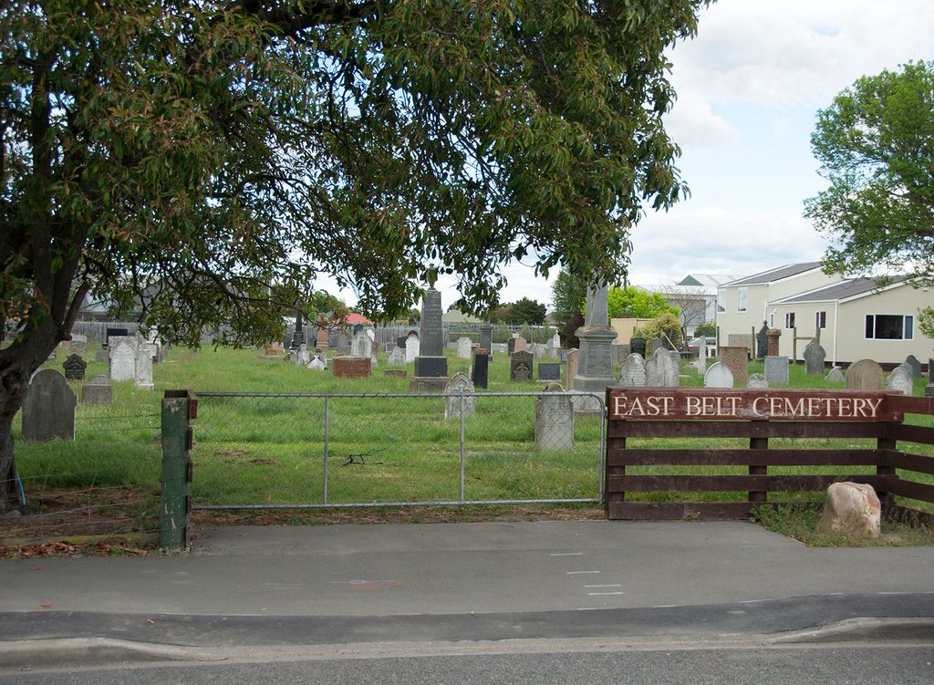
| Description | : | When the Rangiora Anglican Cemetery was denied as a resting place for non-conformists, the other denominations acquired land in East Belt. Sections were donated for the Presbyterians and the Free Methodists while the Baptists collected and bought the adjacent section for their use. The cemetery is now closed for burials. Many of the surrounds have been removed and the tombstones realigned to aid maintenance. The majority of the burials are the Presbyterians. The early Presbyterian settlers from Kaiapoi, Rangiora and the surrounding districts are interred here. When the Free Methodists joined with the Wesleyans, interments were... Read More |
frequently asked questions (FAQ):
-
Where is Rangiora East Belt Cemetery?
Rangiora East Belt Cemetery is located at 105 East Belt Rangiora, Waimakariri District ,Canterbury ,New Zealand.
-
Rangiora East Belt Cemetery cemetery's updated grave count on graveviews.com?
38 memorials
-
Where are the coordinates of the Rangiora East Belt Cemetery?
Latitude: -43.2998190
Longitude: 172.5996450
Nearby Cemetories:
1. Lamb & Hayward Garden of Memories, Wai-mana
Rangiora, Waimakariri District, New Zealand
Coordinate: -43.3018511, 172.6068868
2. St John's Anglican Cemetery
Rangiora, Waimakariri District, New Zealand
Coordinate: -43.2955470, 172.5945540
3. Rangiora Roman Catholic Cemetery
Rangiora, Waimakariri District, New Zealand
Coordinate: -43.3083200, 172.5955100
4. Rangiora Park Lawn Cemetery
Rangiora, Waimakariri District, New Zealand
Coordinate: -43.2908200, 172.5986500
5. Rangiora Methodist Cemetery
Rangiora, Waimakariri District, New Zealand
Coordinate: -43.2909600, 172.5934900
6. Te Uru Ti
Tuahiwi, Waimakariri District, New Zealand
Coordinate: -43.3281100, 172.6455100
7. Te Pa Tu O Hawaiki
Tuahiwi, Waimakariri District, New Zealand
Coordinate: -43.3385430, 172.6445480
8. Woodend Methodist Churchyard
Woodend, Waimakariri District, New Zealand
Coordinate: -43.3195400, 172.6672900
9. St Barnabas Anglican Cemetery
Woodend, Waimakariri District, New Zealand
Coordinate: -43.3137800, 172.6702300
10. St. Paul's Church Cemetery
Flaxton, Waimakariri District, New Zealand
Coordinate: -43.3593380, 172.6065530
11. Saint Brigid's Catholic Cemetery
Loburn, Waimakariri District, New Zealand
Coordinate: -43.2474800, 172.5388100
12. Te Kai a te Atua Urupā
Kaiapoi, Waimakariri District, New Zealand
Coordinate: -43.3595600, 172.6610100
13. Kaiapoi Public Cemetery
Kaiapoi, Waimakariri District, New Zealand
Coordinate: -43.3761690, 172.6364140
14. Mandeville Cemetery
Mandeville North, Waimakariri District, New Zealand
Coordinate: -43.3762080, 172.5408590
15. Kaiapoi Anglican Cemetery
Kaiapoi, Waimakariri District, New Zealand
Coordinate: -43.3909700, 172.6510500
16. Swannanoa Community Churchyard
Swannanoa, Waimakariri District, New Zealand
Coordinate: -43.3701500, 172.4975000
17. Raithby Methodist Cemetery
Loburn, Waimakariri District, New Zealand
Coordinate: -43.2257200, 172.5003500
18. Church of England Terrace Cemetery
Sefton, Waimakariri District, New Zealand
Coordinate: -43.2315300, 172.7139100
19. St Augustine’s Anglican Cemetery
Clarkville, Waimakariri District, New Zealand
Coordinate: -43.4055600, 172.6284700
20. Eyreton St Thomas' Anglican Cemetery
Swannanoa, Waimakariri District, New Zealand
Coordinate: -43.4153900, 172.5508800
21. Balcairn Public Cemetery
Balcairn, Hurunui District, New Zealand
Coordinate: -43.1991770, 172.7102070
22. St Paul's Churchyard
Leithfield, Hurunui District, New Zealand
Coordinate: -43.1912600, 172.7392000
23. Brackenbridge Catholic Cemetery
Balcairn, Hurunui District, New Zealand
Coordinate: -43.1675440, 172.6985610
24. Cust-West Eyreton Cemetery
Cust, Waimakariri District, New Zealand
Coordinate: -43.3183330, 172.3877170