
| Memorials | : | 0 |
| Location | : | Rawmarsh, Metropolitan Borough of Rotherham, England |
| Coordinate | : | 53.4576880, -1.3450730 |
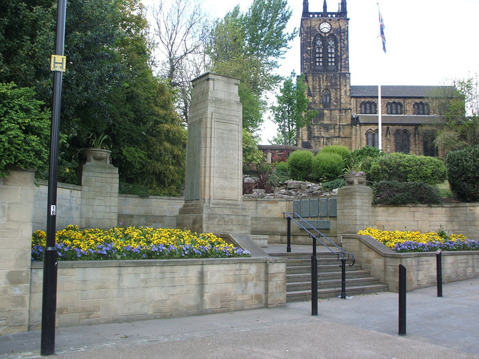
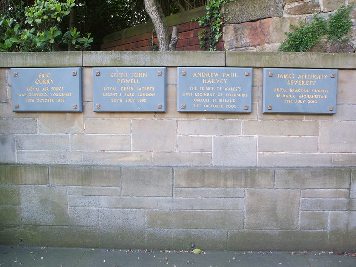
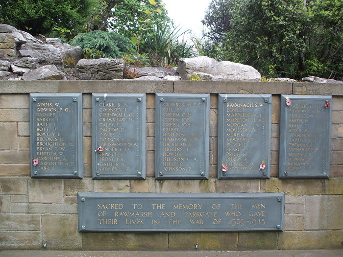
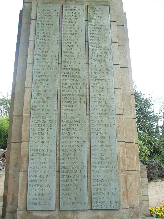
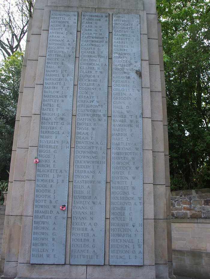
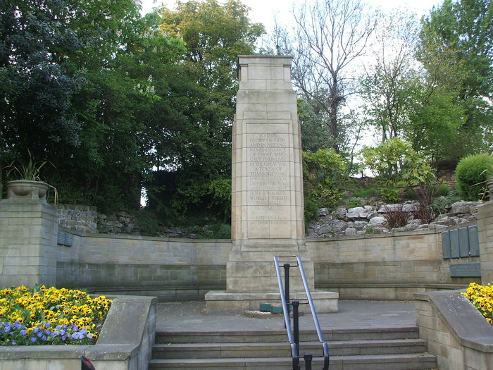
| Description | : | The war memorial,next to the main road, just below St. Mary's Church, Rawmarsh, was unveiled in June 1928, almost ten years after the end of the Great War. It had been intended to use a site near Rawmarsh Baths (demolished 2001). The memorial garden was opened in 1949 in memory of local men killed in the Second World War.In 2009 the war memorial was cleaned and the area surrounding it was provided with new paving and a poppy mosaic. In 1959 a young Fleet Air Arm pilot, Midshipman Ian Ferguson Wilson, from Rotherham was killed when his plane crashed in... Read More |
frequently asked questions (FAQ):
-
Where is Rawmarsh War Memorial?
Rawmarsh War Memorial is located at Rawmarsh, Metropolitan Borough of Rotherham ,South Yorkshire ,England.
-
Rawmarsh War Memorial cemetery's updated grave count on graveviews.com?
0 memorials
-
Where are the coordinates of the Rawmarsh War Memorial?
Latitude: 53.4576880
Longitude: -1.3450730
Nearby Cemetories:
1. High Street Cemetery
Rawmarsh, Metropolitan Borough of Rotherham, England
Coordinate: 53.4587900, -1.3448100
2. Greasbrough Lane Cemetery
Rawmarsh, Metropolitan Borough of Rotherham, England
Coordinate: 53.4620370, -1.3462330
3. Rawmarsh Cemetery
Rawmarsh, Metropolitan Borough of Rotherham, England
Coordinate: 53.4658310, -1.3460880
4. St Mary
Greasbrough, Metropolitan Borough of Rotherham, England
Coordinate: 53.4562120, -1.3717680
5. Greasbrough Cemetery
Rawmarsh, Metropolitan Borough of Rotherham, England
Coordinate: 53.4561300, -1.3849900
6. Rotherham Cholera Burial Ground
Rotherham, Metropolitan Borough of Rotherham, England
Coordinate: 53.4343420, -1.3313390
7. St. Thomas' Churchyard Extension
Kilnhurst, Metropolitan Borough of Rotherham, England
Coordinate: 53.4723700, -1.3072300
8. All Saints Churchyard
Rotherham, Metropolitan Borough of Rotherham, England
Coordinate: 53.4309470, -1.3568280
9. St. Thomas' Churchyard
Rotherham, Metropolitan Borough of Rotherham, England
Coordinate: 53.4303087, -1.3569402
10. Holy Trinity New Cemetery
Dalton, Metropolitan Borough of Rotherham, England
Coordinate: 53.4367969, -1.3129632
11. St Leonard Old Churchyard
Thrybergh, Metropolitan Borough of Rotherham, England
Coordinate: 53.4540200, -1.2976200
12. Masborough Congregational Chapel
Rotherham, Metropolitan Borough of Rotherham, England
Coordinate: 53.4313350, -1.3656320
13. Masbrough Common Cemetery
Rotherham, Metropolitan Borough of Rotherham, England
Coordinate: 53.4321800, -1.3721670
14. Rotherham Crematorium
Rotherham, Metropolitan Borough of Rotherham, England
Coordinate: 53.4329310, -1.3149250
15. St. Bede Roman Catholic Churchyard
Rotherham, Metropolitan Borough of Rotherham, England
Coordinate: 53.4301730, -1.3681120
16. St. Leonard New Churchyard
Thrybergh, Metropolitan Borough of Rotherham, England
Coordinate: 53.4533300, -1.2916900
17. St Paul, Masbrough
Rotherham, Metropolitan Borough of Rotherham, England
Coordinate: 53.4311840, -1.3768820
18. St Margaret Churchyard
Swinton, Metropolitan Borough of Rotherham, England
Coordinate: 53.4890470, -1.3202140
19. Masbrough Cemetery
Rotherham, Metropolitan Borough of Rotherham, England
Coordinate: 53.4326800, -1.3873600
20. Butterfields Memorial Garden
Swinton, Metropolitan Borough of Rotherham, England
Coordinate: 53.4876084, -1.3080726
21. St. Thomas the Apostle Churchyard
Kimberworth, Metropolitan Borough of Rotherham, England
Coordinate: 53.4337400, -1.3936000
22. Moorgate Cemetery
Rotherham, Metropolitan Borough of Rotherham, England
Coordinate: 53.4201742, -1.3537699
23. Wath-Upon-Dearne Cemetery
Wath-upon-Dearne, Metropolitan Borough of Rotherham, England
Coordinate: 53.4979410, -1.3505370
24. St. John The Baptist Churchyard
Hooton Roberts, Metropolitan Borough of Rotherham, England
Coordinate: 53.4683831, -1.2718687