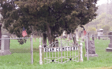
| Memorials | : | 291 |
| Location | : | Sugar Grove, Fairfield County, USA |
| Coordinate | : | 39.6513610, -82.5546500 |
| Description | : | This cemetery is located on the south side of Horns Mill Road (CR 63). It is 1/4 mile east of US 33. The cemetery is located in Berne Township, Fairfield County, Ohio, and is # 3095 (Ream Cemetery) in “Ohio Cemeteries 1803-2003”, compiled by the Ohio Genealogical Society. The cemetery is registered with the Ohio Division of Real Estate and Professional Licensing (ODRE) as Ream with registration license number CGR.0000980269. The U.S. Geological Survey (USGS) Geographic Names Information System (GNIS) feature ID for the cemetery is 1806863 (Ream Cemetery). |
frequently asked questions (FAQ):
-
Where is Ream Cemetery?
Ream Cemetery is located at 2665 Horns Mill Road (County Road 63) Sugar Grove, Fairfield County ,Ohio , 43130USA.
-
Ream Cemetery cemetery's updated grave count on graveviews.com?
287 memorials
-
Where are the coordinates of the Ream Cemetery?
Latitude: 39.6513610
Longitude: -82.5546500
Nearby Cemetories:
1. Stukey Cemetery
Fairfield County, USA
Coordinate: 39.6343994, -82.5558014
2. Tarkiln Cemetery
Berne Township, Fairfield County, USA
Coordinate: 39.6653000, -82.5842240
3. Crawfis-Emery Cemetery
Lancaster, Fairfield County, USA
Coordinate: 39.6787000, -82.5580000
4. Sharp Cemetery
Sugar Grove, Fairfield County, USA
Coordinate: 39.6203003, -82.5535965
5. Phillips Cemetery
Horns Mill, Fairfield County, USA
Coordinate: 39.6475640, -82.5144030
6. Evangelical Lutheran Cemetery
Sugar Grove, Fairfield County, USA
Coordinate: 39.6211761, -82.5423817
7. Sugar Grove Cemetery
Sugar Grove, Fairfield County, USA
Coordinate: 39.6203003, -82.5436020
8. Pleasant Hill Cemetery
Berne Township, Fairfield County, USA
Coordinate: 39.6717239, -82.5084873
9. Brushy Fork Cemetery
Sugar Grove, Fairfield County, USA
Coordinate: 39.6150017, -82.5871964
10. Lamott Cemetery
Fairfield County, USA
Coordinate: 39.6931590, -82.5743200
11. Saint Paul Lutheran Cemetery
North Berne, Fairfield County, USA
Coordinate: 39.6913400, -82.5164000
12. Saint Mary Catholic Cemetery
Lancaster, Fairfield County, USA
Coordinate: 39.6903000, -82.6031036
13. Fairfield School For Boys Cemetery
Lancaster, Fairfield County, USA
Coordinate: 39.6447301, -82.6249481
14. Trinity Sponagle Lutheran Church Cemetery
Sugar Grove, Fairfield County, USA
Coordinate: 39.6159600, -82.4993000
15. Our Lady of Good Hope Catholic Cemetery
Good Hope Township, Hocking County, USA
Coordinate: 39.6036797, -82.6033020
16. Elmwood Cemetery
Lancaster, Fairfield County, USA
Coordinate: 39.7103004, -82.5899963
17. New Saint Thomas Evangelical Lutheran Cemetery
Revenge, Fairfield County, USA
Coordinate: 39.6301994, -82.6345215
18. Richards Family Cemetery
Rockbridge, Hocking County, USA
Coordinate: 39.5853680, -82.5390430
19. Old Saint Thomas Evangelical Lutheran Cemetery
Lancaster, Fairfield County, USA
Coordinate: 39.6306000, -82.6399994
20. Old Lancaster City Graveyard
Lancaster, Fairfield County, USA
Coordinate: 39.7119400, -82.5988940
21. Applegate Cemetery
Lancaster, Fairfield County, USA
Coordinate: 39.7202988, -82.5421982
22. Baron-Graham Family Cemetery
Hideaway Hills, Hocking County, USA
Coordinate: 39.6385070, -82.4657110
23. Asbury Cemetery
Lancaster, Fairfield County, USA
Coordinate: 39.7221985, -82.5558014
24. Saint Emanuel Lutheran Cemetery
Marion Township, Hocking County, USA
Coordinate: 39.6433900, -82.4628000

