
| Memorials | : | 0 |
| Location | : | Haskell County, USA |
| Coordinate | : | 35.2503750, -94.9788430 |
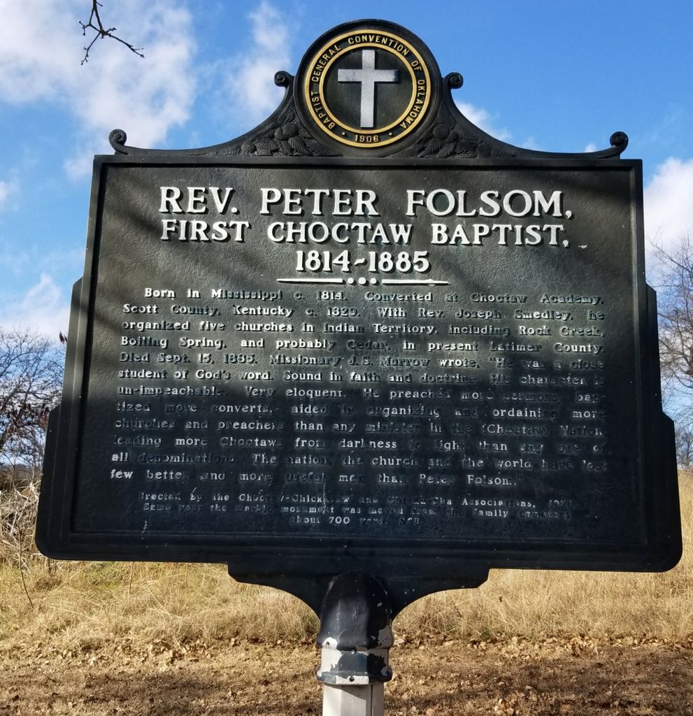
| Description | : | Located on the grounds of the New Hope Church in Haskell, Oklahoma. Latitude and Longitude: Latitude: 35.2503747 Longitude: -94.9788435 GNIS ID: 1095817 Per canvass and survey published in "Our People And Where They Rest," James W. Tyner and Alice Tyner Timmons, American Indian Institute, University of Oklahoma, Norman, OK. 1973, Vol. 8, p. 47 (Library of Congress No. QE99-C5-T97) Their information (including any diagrams or maps) is given here as a historical reference and is presented "as is." Their book, like many such cemetery listing compilations, may contain errors. As with any genealogy information, this is merely... Read More |
frequently asked questions (FAQ):
-
Where is Rev. Peter Folsom Memorial?
Rev. Peter Folsom Memorial is located at Haskell County ,Oklahoma ,USA.
-
Rev. Peter Folsom Memorial cemetery's updated grave count on graveviews.com?
0 memorials
-
Where are the coordinates of the Rev. Peter Folsom Memorial?
Latitude: 35.2503750
Longitude: -94.9788430
Nearby Cemetories:
1. Iron Bridge Cemetery
Ironbridge, Haskell County, USA
Coordinate: 35.2382400, -94.9584300
2. Simon Isaac Cemetery
Haskell County, USA
Coordinate: 35.2803000, -94.9765810
3. Luce
Keota, Haskell County, USA
Coordinate: 35.2199850, -94.9395240
4. Keota Cemetery
Sans Bois Township, Haskell County, USA
Coordinate: 35.2703018, -94.9213028
5. Morris Family Cemetery
Stigler, Haskell County, USA
Coordinate: 35.2449920, -95.0702330
6. Antioch Cemetery
Stigler, Haskell County, USA
Coordinate: 35.2505989, -95.0781021
7. Little Sans Bois Cemetery
Stigler, Haskell County, USA
Coordinate: 35.3339005, -94.9869003
8. Miners Cemetery
McCurtain, Haskell County, USA
Coordinate: 35.1568985, -94.9969025
9. Garland Cemetery
Stigler, Haskell County, USA
Coordinate: 35.3208400, -95.0667900
10. Silome Springs Cemetery
Lequire, Haskell County, USA
Coordinate: 35.1631890, -95.0550940
11. Star Cemetery
Star, Haskell County, USA
Coordinate: 35.3133860, -94.8631000
12. Old Panther Cemetery
McCurtain, Haskell County, USA
Coordinate: 35.1333008, -95.0030975
13. Stigler Cemetery
Stigler, Haskell County, USA
Coordinate: 35.2599910, -95.1310110
14. Milton Cemetery
Milton, Le Flore County, USA
Coordinate: 35.1661000, -94.8629900
15. Old Cache Cemetery
Sans Bois Township, Haskell County, USA
Coordinate: 35.2541000, -94.8217000
16. Sand Spring Cemetery
Stigler, Haskell County, USA
Coordinate: 35.2874985, -95.1343994
17. Tamaha Cemetery
Tamaha, Haskell County, USA
Coordinate: 35.3897018, -94.9702988
18. Old Bokoshe Memorial Gardens
Bokoshe, Le Flore County, USA
Coordinate: 35.2059304, -94.7952273
19. Cariker Cemetery
Bokoshe, Le Flore County, USA
Coordinate: 35.1980560, -94.7825000
20. Cowlington Cemetery
Cowlington, Le Flore County, USA
Coordinate: 35.3102989, -94.7780991
21. Short Mountain Cemetery
Cowlington, Le Flore County, USA
Coordinate: 35.3149986, -94.7733002
22. Tom Girty Cemetery
Muskogee County, USA
Coordinate: 35.4057999, -95.0994034
23. Powell Cemetery
Bokoshe, Le Flore County, USA
Coordinate: 35.2052994, -94.7602997
24. Gorham Lequire Family Cemetery
Lequire, Haskell County, USA
Coordinate: 35.1014250, -95.1119690