
| Memorials | : | 0 |
| Location | : | Patton, Cambria County, USA |
| Coordinate | : | 40.7502700, -78.8525000 |
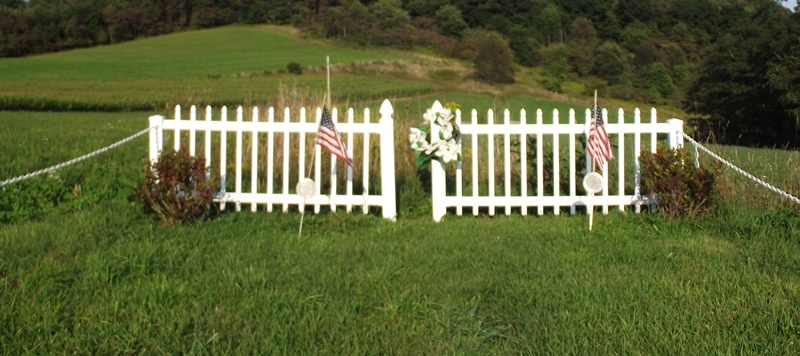
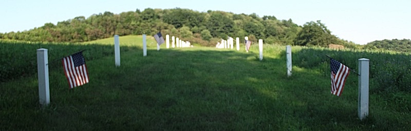
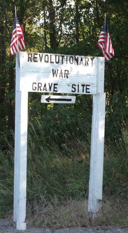
| Description | : | The Eckenrode Mill Village - This Indian village is located by the cemetery, one fourth of a mile south of Eckenrode's mill on the west side of the Chest Creek. All traces of the tombstones have been removed to make room for a baseball ground. Henry J. Link states that when he moved, 1871, onto his farm he found rows of corn stubbles in the dense forest of 40-50 feet tall pine trees, across the Chest creek east of his farm and close to the Kuntzman farm. This would not be a quarter of a mile south of the mill.... Read More |
frequently asked questions (FAQ):
-
Where is Revolutionary War Baum Cemetery?
Revolutionary War Baum Cemetery is located at Patton, Cambria County ,Pennsylvania ,USA.
-
Revolutionary War Baum Cemetery cemetery's updated grave count on graveviews.com?
0 memorials
-
Where are the coordinates of the Revolutionary War Baum Cemetery?
Latitude: 40.7502700
Longitude: -78.8525000
Nearby Cemetories:
1. Hazelet Cemetery
Cherry Tree, Indiana County, USA
Coordinate: 40.7423700, -78.8534180
2. Thompson Cemetery
Hillsdale, Indiana County, USA
Coordinate: 40.7546997, -78.8649979
3. Croasmun Family Cemetery
Indiana County, USA
Coordinate: 40.7312300, -78.8582900
4. Rowley Cemetery
Hillsdale, Indiana County, USA
Coordinate: 40.7649994, -78.8811035
5. Cherry Tree Cemetery
Cherry Tree, Indiana County, USA
Coordinate: 40.7320000, -78.8132000
6. Citizens Cemetery
Cherry Tree, Indiana County, USA
Coordinate: 40.7290000, -78.8121000
7. Montgomery Cemetery
Glen Campbell, Indiana County, USA
Coordinate: 40.7674000, -78.9078000
8. Old Fairview Cemetery
Purchase Line, Indiana County, USA
Coordinate: 40.7631000, -78.9121240
9. East Mahoning Cemetery
Purchase Line, Indiana County, USA
Coordinate: 40.7441000, -78.9227000
10. Henry Cemetery
Indiana County, USA
Coordinate: 40.8033330, -78.8227780
11. Gardner-Bennett Cemetery
Glen Campbell, Indiana County, USA
Coordinate: 40.8064003, -78.8208008
12. Saint Michael's Cemetery
Glen Campbell, Indiana County, USA
Coordinate: 40.8114014, -78.8396988
13. Peles Cemetery
Indiana County, USA
Coordinate: 40.8071510, -78.8201450
14. Patchinville Cemetery
Burnside, Clearfield County, USA
Coordinate: 40.7784900, -78.7754500
15. United Brethren in Christ Church Cemetery
Burnside, Clearfield County, USA
Coordinate: 40.7875600, -78.7801900
16. Cookport Lutheran Cemetery
Cookport, Indiana County, USA
Coordinate: 40.6960000, -78.9170000
17. Burnside Cemetery
Burnside, Clearfield County, USA
Coordinate: 40.8100000, -78.7902000
18. Cookport Methodist Cemetery
Cookport, Indiana County, USA
Coordinate: 40.6925011, -78.9238968
19. Fry Cemetery
Nashville, Indiana County, USA
Coordinate: 40.8213997, -78.9028015
20. Pine Vale Cemetery
Marion Center, Indiana County, USA
Coordinate: 40.7743000, -78.9553000
21. Salem Methodist Cemetery
Indiana County, USA
Coordinate: 40.6678000, -78.8656000
22. McDowell Cemetery
Clymer, Indiana County, USA
Coordinate: 40.6638985, -78.8561020
23. Ranck Family Cemetery
Barnesboro, Cambria County, USA
Coordinate: 40.6734000, -78.7972000
24. Saint John the Baptist Roman Catholic Cemetery
Barnesboro, Cambria County, USA
Coordinate: 40.6737000, -78.7956000