
| Memorials | : | 0 |
| Location | : | Davidson, Fentress County, USA |
| Coordinate | : | 36.2789200, -85.1114000 |
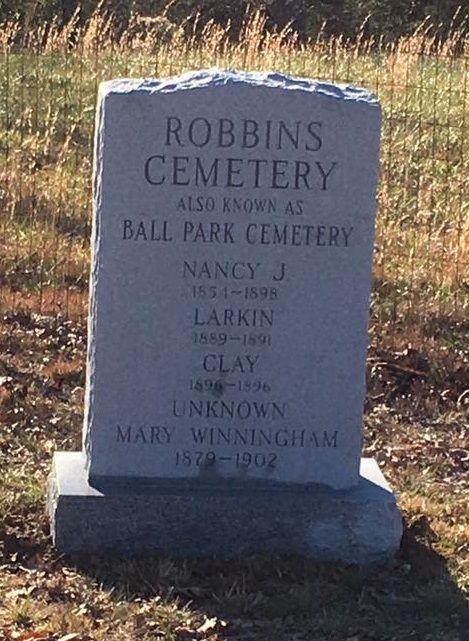
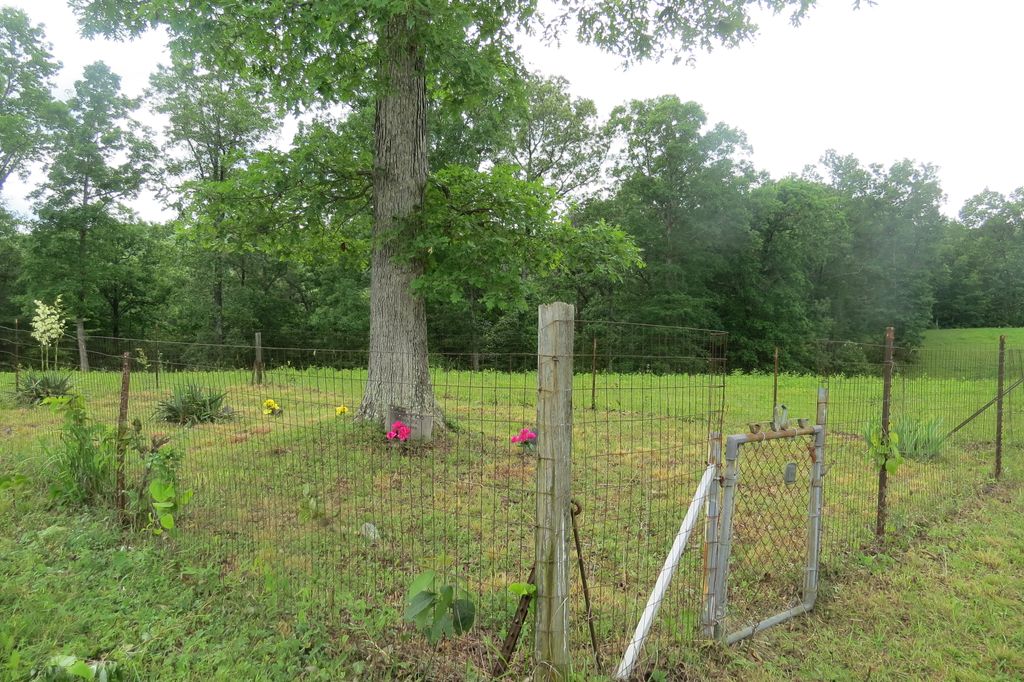
| Description | : | This cemetery is located on what was once the ballfield in the Davidson mining community. There is only one legible stone, and several fieldstones. From Livingston, take TN 52 E and travel 9.3 miles. Turn right onto TN 85 E (Wilder Hwy) and travel 13.1 miles. The cemetery is toward the back of the field on the right. It is beneath a large tree with a fence around it. |
frequently asked questions (FAQ):
-
Where is Robbins Cemetery?
Robbins Cemetery is located at Davidson, Fentress County ,Tennessee ,USA.
-
Robbins Cemetery cemetery's updated grave count on graveviews.com?
0 memorials
-
Where are the coordinates of the Robbins Cemetery?
Latitude: 36.2789200
Longitude: -85.1114000
Nearby Cemetories:
1. Davidson Cemetery
Fentress County, USA
Coordinate: 36.2747002, -85.0991974
2. Welcome Missionary Baptist Church Cemetery
Sandy, Fentress County, USA
Coordinate: 36.2974300, -85.1041200
3. Dillon Farm Cemetery
Sandy, Fentress County, USA
Coordinate: 36.2933000, -85.0711900
4. Sells Cemetery
Fentress County, USA
Coordinate: 36.3161011, -85.1216965
5. Boles Cemetery
Fentress County, USA
Coordinate: 36.3094200, -85.0691500
6. Honey Springs Cemetery
Overton County, USA
Coordinate: 36.2644005, -85.1694031
7. Calvary Freewill Baptist Church Cemetery
Overton County, USA
Coordinate: 36.2359310, -85.1545520
8. Cub Cemetery
Overton County, USA
Coordinate: 36.3058014, -85.1718979
9. George M and Barbara Norrod Phillips Cemetery
Hanging Limb, Overton County, USA
Coordinate: 36.2361910, -85.1633070
10. Hanging Limb Missionary Baptist Cemetery
Hanging Limb, Overton County, USA
Coordinate: 36.2350006, -85.1624985
11. F A Norrod Memorial Cemetery
Hanging Limb, Overton County, USA
Coordinate: 36.2345000, -85.1635000
12. Chapel Flatt Cemetery
Livingston, Overton County, USA
Coordinate: 36.2158012, -85.1307983
13. Shiloh Cemetery
Allred, Overton County, USA
Coordinate: 36.3119011, -85.1866989
14. Walker Mountain Cemetery
Crawford, Overton County, USA
Coordinate: 36.2859840, -85.1977450
15. Goney Cemetery
Grimsley, Fentress County, USA
Coordinate: 36.2771988, -85.0242004
16. Muddy Pond Cemetery
Muddy Pond, Overton County, USA
Coordinate: 36.2066994, -85.1063995
17. Allred Cemetery
Overton County, USA
Coordinate: 36.3269520, -85.1860250
18. Weeks Cemetery
Muddy Pond, Overton County, USA
Coordinate: 36.2010002, -85.0950012
19. Martha Washington Cemetery
Clarkrange, Fentress County, USA
Coordinate: 36.2181470, -85.0432540
20. Davis Cemetery
Overton County, USA
Coordinate: 36.2578011, -85.2114029
21. France Cemetery
Overton County, USA
Coordinate: 36.2313995, -85.1967010
22. Falling Springs Cemetery
Alpine, Overton County, USA
Coordinate: 36.3408012, -85.1813965
23. Muddy Pond Independent Baptist Cemetery
Muddy Pond, Overton County, USA
Coordinate: 36.1941830, -85.1314200
24. Dry Fork Cemetery
Allred, Overton County, USA
Coordinate: 36.2970000, -85.2182900