
| Memorials | : | 2 |
| Location | : | Bethesda, Prince Edward County Municipality, Canada |
| Coordinate | : | 44.1291542, -77.1178513 |
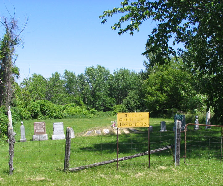
| Description | : | This cemetery, Lot 17, Concession 2, West of Green Point, is situated on the site of the ROBLIN family homestead along the East End of the Fish Lake Road near Highway #49. The family pioneer, John ROBLIN, came to Adolphustown, with a group of others in June of 1784. Although he and his brother, Stephen, wished to remain non-partisan during the American Revolution, they suffered persecution at the hands of the rebels and were forced to flee. When John died in 1812, his wife, Elizabeth MOORE, moved to Sophiasburgh where she married a John CANNIFF. Elizabeth and her first husband,... Read More |
frequently asked questions (FAQ):
-
Where is Roblin Family Cemetery?
Roblin Family Cemetery is located at Bethesda, Prince Edward County Municipality ,Ontario ,Canada.
-
Roblin Family Cemetery cemetery's updated grave count on graveviews.com?
2 memorials
-
Where are the coordinates of the Roblin Family Cemetery?
Latitude: 44.1291542
Longitude: -77.1178513
Nearby Cemetories:
1. Van Horn Farm Cemetery
Sophiasburgh, Prince Edward County Municipality, Canada
Coordinate: 44.1027500, -77.1211000
2. Roblin Mills Cemetery
Sophiasburgh, Prince Edward County Municipality, Canada
Coordinate: 44.1135410, -77.0808730
3. Foster Cemetery
Bethesda, Prince Edward County Municipality, Canada
Coordinate: 44.1069400, -77.1582900
4. All Saints Anglican Church Cemetery
Tyendinaga Mohawk Territory, Hastings County, Canada
Coordinate: 44.1818500, -77.1390570
5. All Saints Church Cemetery
Deseronto, Hastings County, Canada
Coordinate: 44.1824400, -77.1392700
6. Mohawk Pentecostal Cemetery
Deseronto, Hastings County, Canada
Coordinate: 44.1818490, -77.0816910
7. Trumpour Cemetery
Dorland, Lennox and Addington County, Canada
Coordinate: 44.0799940, -77.0594790
8. Christ Church Anglican Cemetery
Tyendinaga Mohawk Territory, Hastings County, Canada
Coordinate: 44.1855650, -77.0734030
9. Hay Bay Quaker Cemetery
Hay Bay, Lennox and Addington County, Canada
Coordinate: 44.0982700, -77.0285400
10. Sophiasburgh Cemetery
Sophiasburgh, Prince Edward County Municipality, Canada
Coordinate: 44.1082790, -77.2155990
11. Demorestville Cemetery
Demorestville, Prince Edward County Municipality, Canada
Coordinate: 44.0932400, -77.2125840
12. Big Island Cemetery
Big Island, Prince Edward County Municipality, Canada
Coordinate: 44.1128630, -77.2256250
13. Diamond Family Burial Ground
The Pines, Lennox and Addington County, Canada
Coordinate: 44.1354370, -77.0016830
14. Parks Cemetery
North Fredericksburgh, Lennox and Addington County, Canada
Coordinate: 44.1447780, -76.9940450
15. Native New Life Cemetery
Tyendinaga Mohawk Territory, Hastings County, Canada
Coordinate: 44.2158100, -77.0755300
16. Saint Vincent de Paul RC Cemetery
Deseronto, Hastings County, Canada
Coordinate: 44.2007360, -77.0299420
17. White Chapel Cemetery
Picton, Prince Edward County Municipality, Canada
Coordinate: 44.0346590, -77.1398130
18. Deseronto Cemetery
Deseronto, Hastings County, Canada
Coordinate: 44.2000000, -77.0276000
19. Desoronto Cemetery
Lennox and Addington County, Canada
Coordinate: 44.2002570, -77.0275390
20. Holy Name of Mary Catholic Cemetery
Marysville, Hastings County, Canada
Coordinate: 44.2238890, -77.1449530
21. Adolphustown United Church Cemetery
Adolphustown, Lennox and Addington County, Canada
Coordinate: 44.0877900, -76.9954400
22. Loyst Cemetery
South Fredericksburgh, Lennox and Addington County, Canada
Coordinate: 44.1416640, -76.9828650
23. Bethel-Doxsee Cemetery
Bethel, Prince Edward County Municipality, Canada
Coordinate: 44.0547120, -77.2077730
24. Riverview Cemetery
Shannonville, Hastings County, Canada
Coordinate: 44.1921770, -77.2325600