
| Memorials | : | 0 |
| Location | : | Bolivar, Hardeman County, USA |
| Coordinate | : | 35.2647750, -89.0000540 |
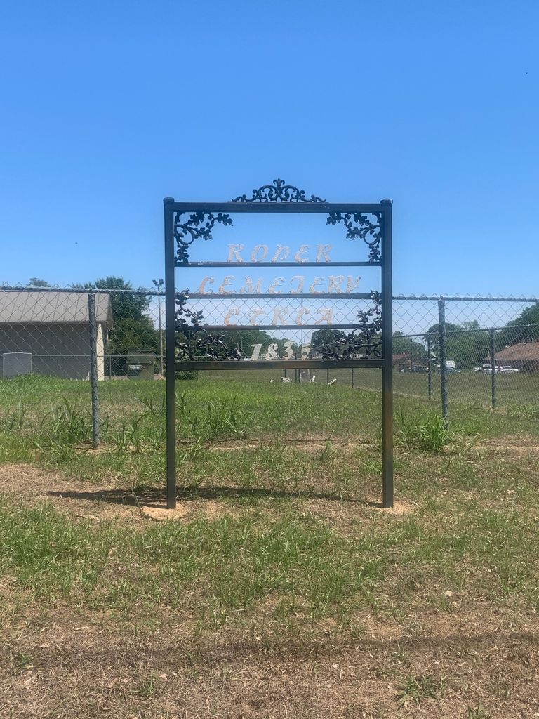
| Description | : | Located near the intersection of Tate Road and Nuckolls Road, on the east side of Hudsons Drug Store. Roper Cemetery is a circa 1835 Cemetery that was destroyed by a bulldozer in 1981. Most of the monuments were destroyed. A new single monument was erected at the sight with names of some people buried there. The cemetery is now enclosed by a chain link fence. A new single monument was erected on the sight after the bulldozer incident. The single monument lists some of the people buried there but, not all. |
frequently asked questions (FAQ):
-
Where is Roper Cemetery?
Roper Cemetery is located at 816 Tate Road Bolivar, Hardeman County ,Tennessee , 38008USA.
-
Roper Cemetery cemetery's updated grave count on graveviews.com?
0 memorials
-
Where are the coordinates of the Roper Cemetery?
Latitude: 35.2647750
Longitude: -89.0000540
Nearby Cemetories:
1. Nuckolls Cemetery
Bolivar, Hardeman County, USA
Coordinate: 35.2647530, -89.0009530
2. Bolivar Hospital Mass Grave
Bolivar, Hardeman County, USA
Coordinate: 35.2539620, -88.9905550
3. Polk Cemetery
Bolivar, Hardeman County, USA
Coordinate: 35.2517140, -88.9938710
4. Bolivar Cemetery
Bolivar, Hardeman County, USA
Coordinate: 35.2562980, -88.9841250
5. Bolivar Memorial Cemetery
Bolivar, Hardeman County, USA
Coordinate: 35.2495390, -88.9920520
6. Union Cemetery
Bolivar, Hardeman County, USA
Coordinate: 35.2540820, -88.9833530
7. Bills Family Cemetery
Bolivar, Hardeman County, USA
Coordinate: 35.2549380, -88.9819960
8. Bolivar Community Cemetery
Bolivar, Hardeman County, USA
Coordinate: 35.2539550, -88.9810320
9. Patrick Cemetery
Bolivar, Hardeman County, USA
Coordinate: 35.2449260, -88.9955410
10. Western State Hospital Cemetery
Bolivar, Hardeman County, USA
Coordinate: 35.2776200, -89.0265000
11. Hazelgrove Cemetery
Bolivar, Hardeman County, USA
Coordinate: 35.2311000, -88.9975400
12. Pleasant Grove Methodist Church Cemetery
Bolivar, Hardeman County, USA
Coordinate: 35.2278710, -88.9814020
13. Shandy Baptist Church Cemetery
Bolivar, Hardeman County, USA
Coordinate: 35.2921850, -88.9588950
14. Parrans Chapel Baptist Church Cemetery
Bolivar, Hardeman County, USA
Coordinate: 35.2768860, -89.0543400
15. Spring Hill Methodist Cemetery
Bolivar, Hardeman County, USA
Coordinate: 35.2197790, -89.0135440
16. Clifft Cemetery
Bolivar, Hardeman County, USA
Coordinate: 35.2241460, -89.0276950
17. Jones-Marsh Cemetery
Shandy, Hardeman County, USA
Coordinate: 35.3113440, -88.9730490
18. Bethlehem Missionary Baptist Church Cemetery
Bolivar, Hardeman County, USA
Coordinate: 35.3030230, -89.0467960
19. Matthews Cemetery
Bolivar, Hardeman County, USA
Coordinate: 35.2463020, -89.0666700
20. Hill Field Baptist Church Cemetery
Toone, Hardeman County, USA
Coordinate: 35.3080100, -88.9515600
21. Black-Ruffin Cemetery
Toone, Hardeman County, USA
Coordinate: 35.3216550, -88.9822160
22. Ervin Cemetery
Bolivar, Hardeman County, USA
Coordinate: 35.2856680, -88.9312300
23. Ussery Cemetery
Bolivar, Hardeman County, USA
Coordinate: 35.2188988, -89.0539017
24. Willoughby Cemetery
Bolivar, Hardeman County, USA
Coordinate: 35.3179020, -88.9490010