
| Memorials | : | 5 |
| Location | : | Rich Patch, Alleghany County, USA |
| Coordinate | : | 37.7380981, -79.9088974 |
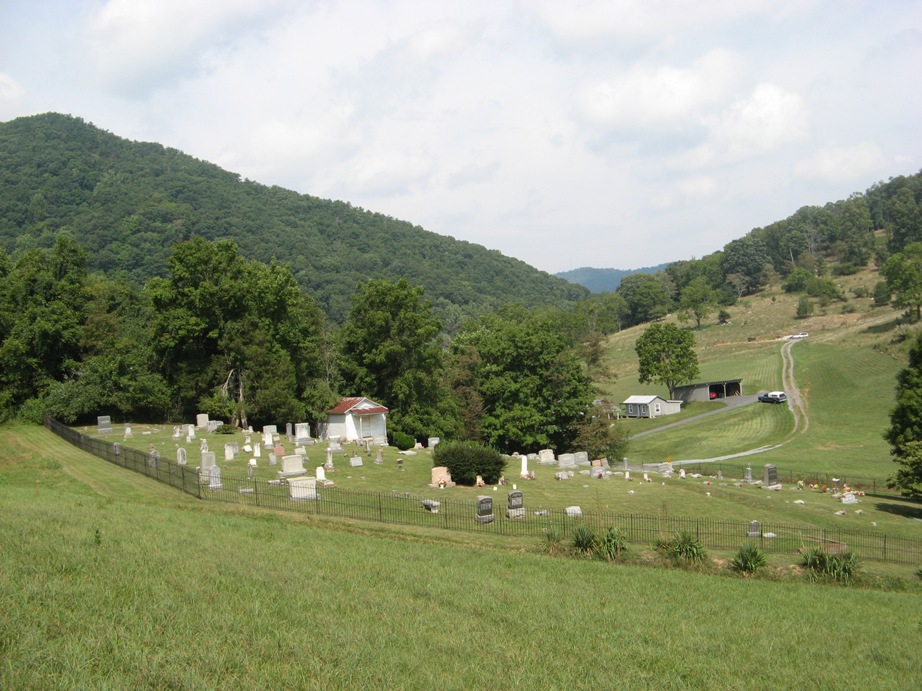
| Description | : | From Covington, take I-64 east to the Low Moor exit. Turn right and proceed through railroad underpass to Rich Patch Road and turn right. Follow Rich Patch Road 4.3 miles to Rose Hill Lane on the left. Follow Rose Hill Lane .5 mile where the cemetery is on the right. It is well kept in an enclosed fence and still in use. |
frequently asked questions (FAQ):
-
Where is Rosehill Cemetery?
Rosehill Cemetery is located at Rich Patch, Alleghany County ,Virginia ,USA.
-
Rosehill Cemetery cemetery's updated grave count on graveviews.com?
2 memorials
-
Where are the coordinates of the Rosehill Cemetery?
Latitude: 37.7380981
Longitude: -79.9088974
Nearby Cemetories:
1. Hooks Cemetery
Alleghany County, USA
Coordinate: 37.7275009, -79.9396973
2. Longdale Cemetery
Eagle Rock, Botetourt County, USA
Coordinate: 37.6939100, -79.8962400
3. Alleghany Memorial Park
Low Moor, Alleghany County, USA
Coordinate: 37.7877998, -79.9030991
4. Mallow Cemetery
Alleghany County, USA
Coordinate: 37.7613983, -79.9677963
5. Karnes Family Cemetery
Low Moor, Alleghany County, USA
Coordinate: 37.7872650, -79.8853640
6. Mount Carmel Cemetery
Low Moor, Alleghany County, USA
Coordinate: 37.7879370, -79.8869510
7. Sunrise Cemetery
Low Moor, Alleghany County, USA
Coordinate: 37.7877220, -79.8860710
8. Haden Cemetery
Botetourt County, USA
Coordinate: 37.7228012, -79.8411026
9. Wood Cemetery
Glen Wilton, Botetourt County, USA
Coordinate: 37.7358000, -79.8300080
10. Humphries Cemetery
Rich Patch, Alleghany County, USA
Coordinate: 37.7010994, -79.9794006
11. Edgemont Cemetery
Covington, Covington City, USA
Coordinate: 37.7581025, -79.9909477
12. Mount Beulah Baptist Church Cemetery
Glen Wilton, Botetourt County, USA
Coordinate: 37.7545310, -79.8255680
13. Cedar Hill Cemetery
Covington, Covington City, USA
Coordinate: 37.7736015, -79.9831009
14. Oakland Grove Presbyterian Church and Cemetery
Selma, Alleghany County, USA
Coordinate: 37.8018000, -79.8603000
15. Locust Bottom Cemetery
Botetourt County, USA
Coordinate: 37.7414850, -79.8145640
16. Parr Family Cemetery
Eagle Rock, Botetourt County, USA
Coordinate: 37.6587620, -79.9023250
17. Bethel Cemetery
Eagle Rock, Botetourt County, USA
Coordinate: 37.7487190, -79.7982530
18. Simmons Cemetery
Alleghany County, USA
Coordinate: 37.6768990, -79.9922028
19. Unidentified Family Plot
Boiling Spring, Alleghany County, USA
Coordinate: 37.7245268, -80.0249562
20. Galatia Presbyterian Church Cemetery
Eagle Rock, Botetourt County, USA
Coordinate: 37.6855320, -79.8072950
21. Rising Mount Zion Baptist Church Cemetery
Eagle Rock, Botetourt County, USA
Coordinate: 37.6895860, -79.8029400
22. Crown Hill Cemetery
Clifton Forge, Alleghany County, USA
Coordinate: 37.8139000, -79.8171997
23. Lemon Cemetery
Botetourt County, USA
Coordinate: 37.7712593, -79.7816010
24. Mountain View Cemetery
Clifton Forge, Alleghany County, USA
Coordinate: 37.8135986, -79.8139038