
| Memorials | : | 0 |
| Location | : | Alleghany County, USA |
| Coordinate | : | 37.6768990, -79.9922028 |
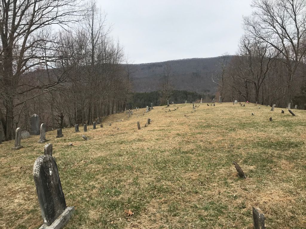
| Description | : | Cemetery Location: 13 miles southwest of Covington, Virginia, Route #60, Route #18, Route #619, Route #616, Route #618. When leaving Route #616 in Upper Richpatch, turn south on Route #618, go 1 mile to Geo. Simmons on the south of the road. Cemetery lies on a high hill to the southeast of his house. Alleghany County DESCRIPTION: The cemetery is situated on a high hill on the north side of Rich Patch or Big Mountain. An open and magnificent view of historic Nichols Knob and the Upper Rich Patch Valley may be seen from the cemetery hill.... Read More |
frequently asked questions (FAQ):
-
Where is Simmons Cemetery?
Simmons Cemetery is located at Alleghany County ,Virginia ,USA.
-
Simmons Cemetery cemetery's updated grave count on graveviews.com?
0 memorials
-
Where are the coordinates of the Simmons Cemetery?
Latitude: 37.6768990
Longitude: -79.9922028
Nearby Cemetories:
1. Humphries Cemetery
Rich Patch, Alleghany County, USA
Coordinate: 37.7010994, -79.9794006
2. King Memorial Cemetery
Oriskany, Botetourt County, USA
Coordinate: 37.6383018, -79.9633026
3. Unidentified Family Plot
Boiling Spring, Alleghany County, USA
Coordinate: 37.7245268, -80.0249562
4. Oriskany Cemetery
Botetourt County, USA
Coordinate: 37.6168000, -79.9832700
5. McKalester Cemetery
Botetourt County, USA
Coordinate: 37.6213989, -79.9599991
6. Persinger Memorial Cemetery
Alleghany County, USA
Coordinate: 37.7167000, -80.0532000
7. Caldwell Family Cemetery
Alleghany County, USA
Coordinate: 37.7263400, -80.0460700
8. Hooks Cemetery
Alleghany County, USA
Coordinate: 37.7275009, -79.9396973
9. Anderson Family Cemetery
Oriskany, Botetourt County, USA
Coordinate: 37.6114900, -79.9804100
10. Johnson Helmintoller Plymale Cemetery
Potts Creek, Alleghany County, USA
Coordinate: 37.7105190, -80.0662460
11. Tucker Cemetery
Botetourt County, USA
Coordinate: 37.6072006, -79.9700012
12. Parr Family Cemetery
Eagle Rock, Botetourt County, USA
Coordinate: 37.6587620, -79.9023250
13. Bowyer Cemetery
Jordan Mines, Alleghany County, USA
Coordinate: 37.7039580, -80.0788810
14. Longdale Cemetery
Eagle Rock, Botetourt County, USA
Coordinate: 37.6939100, -79.8962400
15. Edgemont Cemetery
Covington, Covington City, USA
Coordinate: 37.7581025, -79.9909477
16. Mallow Cemetery
Alleghany County, USA
Coordinate: 37.7613983, -79.9677963
17. Crawford Cemetery
Botetourt County, USA
Coordinate: 37.5894012, -79.9931030
18. Rosehill Cemetery
Rich Patch, Alleghany County, USA
Coordinate: 37.7380981, -79.9088974
19. Lone Star Cemetery
Jordan Mines, Alleghany County, USA
Coordinate: 37.6760000, -80.1109000
20. Cedar Hill Cemetery
Covington, Covington City, USA
Coordinate: 37.7736015, -79.9831009
21. Stone Family Cemetery
Potts Creek, Alleghany County, USA
Coordinate: 37.6708210, -80.1378500
22. Hebron United Methodist Church Cemetery
New Castle, Craig County, USA
Coordinate: 37.5564900, -80.0046000
23. McCartney Family Cemetery
New Castle, Craig County, USA
Coordinate: 37.5623600, -80.0422500
24. Helmintoller Cemetery
Alleghany County, USA
Coordinate: 37.7846985, -80.0746994