
| Memorials | : | 1 |
| Location | : | Mound Valley, Labette County, USA |
| Coordinate | : | 37.1900490, -95.4763840 |
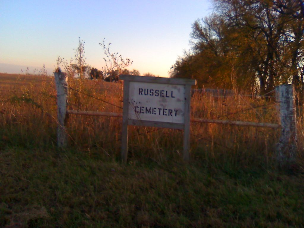
| Description | : | The cemetery is located 5.5 miles west of Mound Valley, Kansas on Highway 160. It is on top of the hill. The entrace is on the south side of the highway. Once you go through the gate it is approxiametly 800 yards south and sits on top of a small hill. The cemetery has a fence and gate on it as well. The sign to the cemetery says "RUSSELL CEMETERY" and is posted to the east of the entrance gate to the field. |
frequently asked questions (FAQ):
-
Where is Russell Cemetery?
Russell Cemetery is located at Mound Valley, Labette County ,Kansas ,USA.
-
Russell Cemetery cemetery's updated grave count on graveviews.com?
1 memorials
-
Where are the coordinates of the Russell Cemetery?
Latitude: 37.1900490
Longitude: -95.4763840
Nearby Cemetories:
1. McKinzie Cemetery
Labette County, USA
Coordinate: 37.1634540, -95.4411830
2. Shelton Mausoleum
Liberty, Montgomery County, USA
Coordinate: 37.1857760, -95.5490630
3. Griffith Cemetery
Labette County, USA
Coordinate: 37.2463989, -95.4981003
4. Richland Cemetery
Angola, Labette County, USA
Coordinate: 37.1342000, -95.4475000
5. Mound Valley Cemetery
Mound Valley, Labette County, USA
Coordinate: 37.1998770, -95.3990600
6. Tibbets Family Cemetery
Mound Valley, Labette County, USA
Coordinate: 37.1456400, -95.4122700
7. Penfield Cemetery
Mound Valley, Labette County, USA
Coordinate: 37.1455994, -95.4122009
8. Centennial Cemetery
Cherryvale, Montgomery County, USA
Coordinate: 37.2296982, -95.5466995
9. All Saints Cemetery
Liberty, Montgomery County, USA
Coordinate: 37.1542015, -95.5757980
10. Fairview Cemetery
Cherryvale, Montgomery County, USA
Coordinate: 37.2722015, -95.5344009
11. Hopewell Cemetery
Mound Valley, Labette County, USA
Coordinate: 37.2453003, -95.3741989
12. Vance Cemetery
Labette County, USA
Coordinate: 37.2075005, -95.3488998
13. Harmony Cemetery
Cherryvale, Montgomery County, USA
Coordinate: 37.2324982, -95.5950012
14. Liberty Cemetery
Liberty, Montgomery County, USA
Coordinate: 37.1581890, -95.6001580
15. Saint Francis Xavier Cemetery
Cherryvale, Montgomery County, USA
Coordinate: 37.2633018, -95.5753021
16. Thompson Homestead Cemetery
Liberty, Montgomery County, USA
Coordinate: 37.1767000, -95.6183100
17. Hinton Cemetery
Liberty, Montgomery County, USA
Coordinate: 37.1384900, -95.6101000
18. Spindletop Cemetery
Cherryvale, Montgomery County, USA
Coordinate: 37.2958400, -95.5570700
19. Wilsonton Cemetery
Parsons, Labette County, USA
Coordinate: 37.2597700, -95.3397800
20. Wooden Cemetery
Altamont, Labette County, USA
Coordinate: 37.1486015, -95.3225021
21. Harmony Grove Cemetery
Dennis, Labette County, USA
Coordinate: 37.3255997, -95.4580994
22. Union Cemetery
Montgomery County, USA
Coordinate: 37.0630989, -95.5408020
23. Montgomery County Poor Farm Cemetery
Liberty, Montgomery County, USA
Coordinate: 37.1888590, -95.6493690
24. Mount Pleasant Cemetery
Altamont, Labette County, USA
Coordinate: 37.1802540, -95.2971480