
| Memorials | : | 0 |
| Location | : | Drew, Sunflower County, USA |
| Coordinate | : | 33.8611800, -90.5732400 |
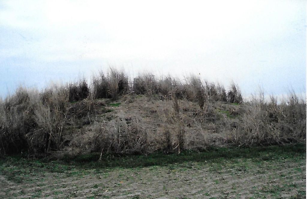
| Description | : | At Drew, turn left onto West Park off Highway 49W at the traffic light. Continue to Swiggins about 5 miles west, turn onto long Lake Road, Sandy Bayou Cemetery is 1/4 mile on the right. Continue on down Long Lake Road for 1/2 mile. Take a right turn on the Grittman Road and go 1/2 mile. Rutherford Cemetery is located on the left, on the only mound in the area and overgrown with weeds taller than your head and vines entangled on the ground. Only five graves were listed, all of those being the Rutherford family plot, enclosed in an iron... Read More |
frequently asked questions (FAQ):
-
Where is Rutherford Cemetery?
Rutherford Cemetery is located at Drew, Sunflower County ,Mississippi ,USA.
-
Rutherford Cemetery cemetery's updated grave count on graveviews.com?
0 memorials
-
Where are the coordinates of the Rutherford Cemetery?
Latitude: 33.8611800
Longitude: -90.5732400
Nearby Cemetories:
1. Sandy Bayou Cemetery
Sunflower County, USA
Coordinate: 33.8521996, -90.5808029
2. New Jerusalem M. B. Church Cemetery
Drew, Sunflower County, USA
Coordinate: 33.8776900, -90.5752800
3. Mount Moriah Church Cemetery
Whitney, Sunflower County, USA
Coordinate: 33.8550700, -90.5369400
4. Shady Grove Cemetery
Sunflower County, USA
Coordinate: 33.8786011, -90.6207962
5. Pilgrim Rest Cemetery
Lombardy, Sunflower County, USA
Coordinate: 33.9007988, -90.6156006
6. Drew Cemetery
Drew, Sunflower County, USA
Coordinate: 33.8194008, -90.5242004
7. Aldridge Cemetery
Lombardy, Sunflower County, USA
Coordinate: 33.8810690, -90.6449850
8. Drew Colored Cemetery
Drew, Sunflower County, USA
Coordinate: 33.8069420, -90.5258670
9. Pilgrim Rest Cemetery
Fitzhugh, Sunflower County, USA
Coordinate: 33.8764000, -90.4916992
10. Mississippi State Prison Cemetery
Parchman, Sunflower County, USA
Coordinate: 33.9231300, -90.5283900
11. Parchman Farm Cemetery
Parchman, Sunflower County, USA
Coordinate: 33.9274500, -90.5153300
12. Clay Church Road Cemetery
Drew, Sunflower County, USA
Coordinate: 33.9157295, -90.6525955
13. Wanderer's Home Cemetery
Mound Bayou, Bolivar County, USA
Coordinate: 33.8799200, -90.6833300
14. Beautiful Star Church Cemetery
Mound Bayou, Bolivar County, USA
Coordinate: 33.9007900, -90.6752100
15. Pilgrim Rest Church Cemetery
Jaquith, Sunflower County, USA
Coordinate: 33.7676700, -90.5386600
16. Turner Chapel Cemetery
Dockery, Sunflower County, USA
Coordinate: 33.7651300, -90.5961200
17. Marshall Cemetery
Sunflower County, USA
Coordinate: 33.7630997, -90.5899963
18. Tharp Cemetery
Rome, Sunflower County, USA
Coordinate: 33.9424200, -90.5015500
19. Union Grove Cemetery
Cleveland, Bolivar County, USA
Coordinate: 33.7876816, -90.6574326
20. Union Grove Cemetery
Dockery, Sunflower County, USA
Coordinate: 33.7875400, -90.6579200
21. Spring Hill Church Cemetery
Winstonville, Bolivar County, USA
Coordinate: 33.9234400, -90.6758100
22. Pleasant Green Cemetery
Sunflower County, USA
Coordinate: 33.9417000, -90.4856033
23. Mount Olive Cemetery
Sunflower County, USA
Coordinate: 33.7977982, -90.4633026
24. Merigold-Drew Road Cemetery
Merigold, Bolivar County, USA
Coordinate: 33.8318770, -90.7031910