
| Memorials | : | 4 |
| Location | : | Rutland, Worcester County, USA |
| Coordinate | : | 42.3988500, -71.9923800 |
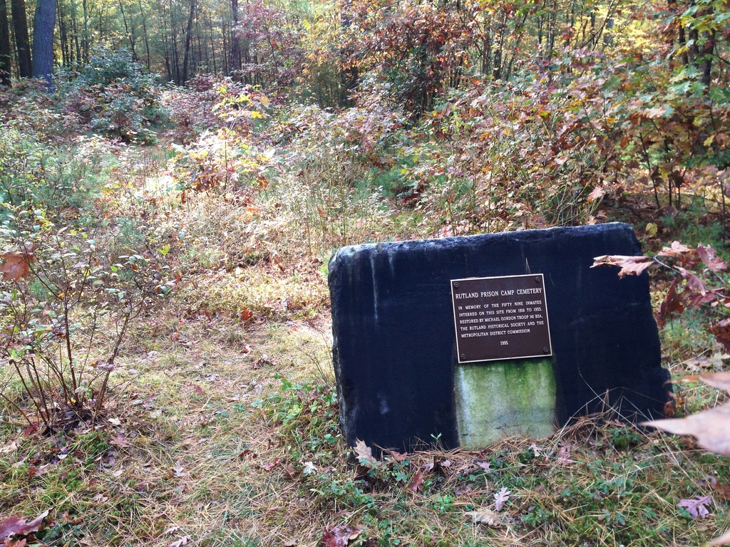
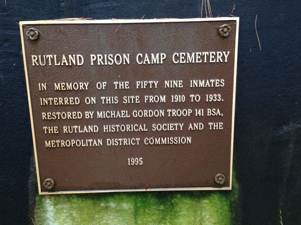
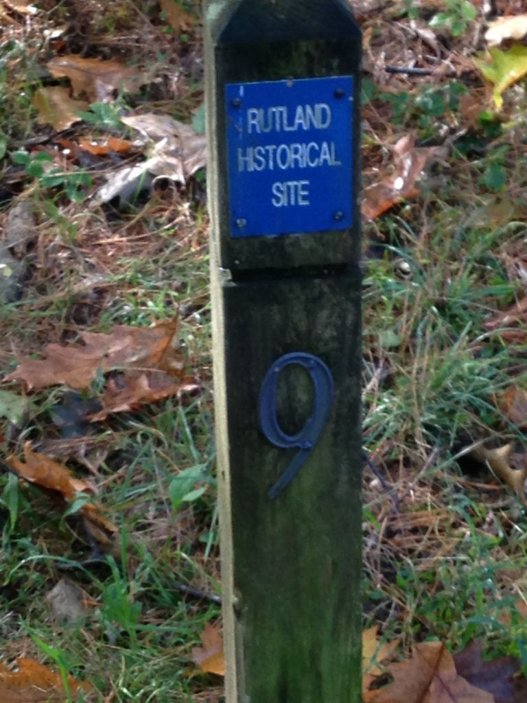
| Description | : | This cemetery is located behind Goose Hill Cemetery at approximately 245 Charnock Hill Road. Next to the entrance to Goose Hill Cemetery there is a marker that reads Rutland Historical Site 9. To get to the Prison Camp Cemetery follow the path by the marker for approximately ¼ - ½ mile to a clearing where the memorial plaque is located. From the Town of Rutland website: In 1903 the General Court established an industrial camp for prisoners to reclaim and improve wasted lands. The Commonwealth purchased 914 acres in Rutland. A dormitory and other buildings were built and upon... Read More |
frequently asked questions (FAQ):
-
Where is Rutland Prison Camp Cemetery?
Rutland Prison Camp Cemetery is located at Charnock Hill Road Rutland, Worcester County ,Massachusetts ,USA.
-
Rutland Prison Camp Cemetery cemetery's updated grave count on graveviews.com?
4 memorials
-
Where are the coordinates of the Rutland Prison Camp Cemetery?
Latitude: 42.3988500
Longitude: -71.9923800
Nearby Cemetories:
1. Goose Hill Cemetery
Rutland, Worcester County, USA
Coordinate: 42.3997400, -71.9914000
2. Old Burial Ground
Rutland, Worcester County, USA
Coordinate: 42.3756000, -71.9578000
3. Parker Cemetery
Barre, Worcester County, USA
Coordinate: 42.4250800, -72.0240400
4. Rutland Rural Cemetery
Rutland, Worcester County, USA
Coordinate: 42.3790100, -71.9447500
5. West Rutland Cemetery
Rutland, Worcester County, USA
Coordinate: 42.3561970, -71.9897170
6. Route 62 Cemetery
Hubbardston, Worcester County, USA
Coordinate: 42.4426910, -72.0014980
7. Coldbrook Cemetery
Barre, Worcester County, USA
Coordinate: 42.3944016, -72.0541992
8. Riverside Cemetery
Barre, Worcester County, USA
Coordinate: 42.4185982, -72.0516968
9. Green Hollow Cemetery
Oakham, Worcester County, USA
Coordinate: 42.3549995, -72.0243988
10. Smith Family Cemetery
Rutland, Worcester County, USA
Coordinate: 42.3946064, -71.9231169
11. Putnam Farm Cemetery
Rutland, Worcester County, USA
Coordinate: 42.3484010, -71.9771420
12. Oakham Center Cemetery
Oakham, Worcester County, USA
Coordinate: 42.3540000, -72.0421400
13. Walker Burial Ground
Barre, Worcester County, USA
Coordinate: 42.4374500, -72.0605600
14. Evergreen Cemetery
Hubbardston, Worcester County, USA
Coordinate: 42.4630750, -71.9974320
15. Rural Glen Cemetery
Hubbardston, Worcester County, USA
Coordinate: 42.4653015, -71.9985962
16. Caldwell Cemetery
Barre, Worcester County, USA
Coordinate: 42.4105988, -72.0817032
17. Brookside Cemetery
Hubbardston, Worcester County, USA
Coordinate: 42.4662700, -71.9993400
18. West Cemetery
Princeton, Worcester County, USA
Coordinate: 42.4454100, -71.9256500
19. Pine Grove Cemetery
Hubbardston, Worcester County, USA
Coordinate: 42.4653015, -72.0119019
20. South Cemetery
Oakham, Worcester County, USA
Coordinate: 42.3382988, -72.0374985
21. Southwest Cemetery
Oakham, Worcester County, USA
Coordinate: 42.3457985, -72.0582962
22. Pine Grove Cemetery
Oakham, Worcester County, USA
Coordinate: 42.3640900, -72.0781900
23. Kendal Plain Cemetery
Barre, Worcester County, USA
Coordinate: 42.4119500, -72.0901100
24. South Burying Ground
Princeton, Worcester County, USA
Coordinate: 42.4192009, -71.8957977