
| Memorials | : | 0 |
| Location | : | Cullompton, Mid Devon District, England |
| Coordinate | : | 50.8556600, -3.3911490 |
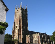
| Description | : | (Cullompton Town Cemetery was established 1856. Burials previous to 1856 would be in St Andrews) Church St, Cullompton, Devon County EX15 1JU 353 ft E 01884 33249 standrewscullompton.com St Andrew's Church Office Pye Corner Cullompton Devon EX15 1JX St Andrew's church is located on Church Street. If you are coming from the motorway, go towards the town centre (Station Road - B3181), at the T-junction and traffic lights turn left (High Street – B3181), the church is set back on the left hand side at the end of Church Street. The church is open between 9.15am and 1pm on weekdays, closed on Saturdays and open... Read More |
frequently asked questions (FAQ):
-
Where is Saint Andrews Churchyard?
Saint Andrews Churchyard is located at Church St Cullompton, Mid Devon District ,Devon , EX15 1JUEngland.
-
Saint Andrews Churchyard cemetery's updated grave count on graveviews.com?
0 memorials
-
Where are the coordinates of the Saint Andrews Churchyard?
Latitude: 50.8556600
Longitude: -3.3911490
Nearby Cemetories:
1. Cullompton Cemetery
Cullompton, Mid Devon District, England
Coordinate: 50.8575110, -3.3980540
2. Cullompton Extension Cemetery
Cullompton, Mid Devon District, England
Coordinate: 50.8582213, -3.4015115
3. St Dionysius Churchyard
Bradninch, Mid Devon District, England
Coordinate: 50.8282770, -3.4223910
4. Bradninch Burial Ground
Bradninch, Mid Devon District, England
Coordinate: 50.8278200, -3.4214200
5. Bradninch Baptist Burial Ground
Bradninch, Mid Devon District, England
Coordinate: 50.8262100, -3.4199400
6. Bradninch Cemetery
Bradninch, Mid Devon District, England
Coordinate: 50.8240850, -3.4215970
7. All Saints Chapelyard
Uffculme, Mid Devon District, England
Coordinate: 50.8803000, -3.3468855
8. St Matthews
Butterleigh, Mid Devon District, England
Coordinate: 50.8636990, -3.4581720
9. St Mary Churchyard
Kentisbeare, Mid Devon District, England
Coordinate: 50.8653700, -3.3233200
10. United Reform Churchyard
Plymtree, East Devon District, England
Coordinate: 50.8240790, -3.3420350
11. St. John the Baptist Churchyard
Plymtree, East Devon District, England
Coordinate: 50.8177000, -3.3474880
12. St. Andrew's Churchyard
Halberton, Mid Devon District, England
Coordinate: 50.9069040, -3.4155350
13. United Reform Church
Uffculme, Mid Devon District, England
Coordinate: 50.9043090, -3.3341120
14. Clyst St Lawrence Parish Church
Clyst St Lawrence, East Devon District, England
Coordinate: 50.7942820, -3.3764350
15. St John the Baptist Churchyard
Sampford Peverell, Mid Devon District, England
Coordinate: 50.9200000, -3.3830000
16. St. Mary The Virgin Churchyard
Uffculme, Mid Devon District, England
Coordinate: 50.9062290, -3.3259862
17. Uffculme Cemetery
Uffculme, Mid Devon District, England
Coordinate: 50.9033630, -3.3202260
18. St Marys Churchyard
Silverton, Mid Devon District, England
Coordinate: 50.8152560, -3.4822370
19. St. Mary the Virgin Churchyard
Bickleigh, Mid Devon District, England
Coordinate: 50.8544800, -3.5038000
20. St. Peter's Churchyard
Uplowman, Mid Devon District, England
Coordinate: 50.9305600, -3.4053000
21. St George Churchyard Tiverton
Tiverton, Mid Devon District, England
Coordinate: 50.9023890, -3.4884920
22. St Peter Churchyard
Tiverton, Mid Devon District, England
Coordinate: 50.9055160, -3.4887900
23. Tiverton Cemetery
Tiverton, Mid Devon District, England
Coordinate: 50.9119940, -3.4858730
24. Spiceland Quaker Burial Ground
Uffculme, Mid Devon District, England
Coordinate: 50.9186560, -3.3067630