
| Memorials | : | 30 |
| Location | : | Emporia, Lyon County, USA |
| Coordinate | : | 38.4084053, -96.1796799 |
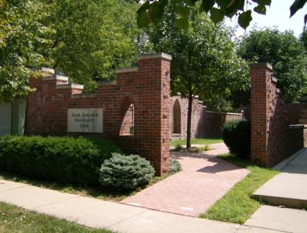
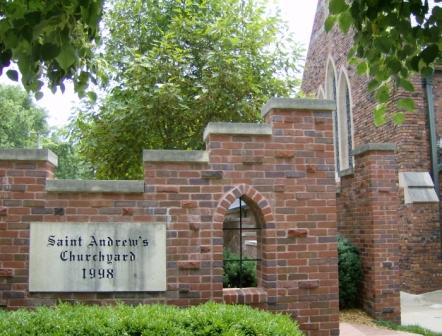
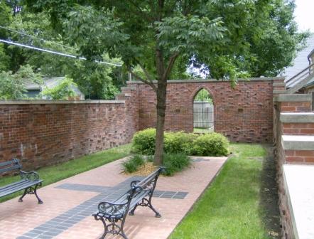
| Description | : | St. Andrew's Churchyard Columbarium provides burial in the "arms of the Church" for members and friends. Ashes are poured directly into the ground or buried in a biodegradable container. Memorial plaques of persons buried here, as well as memorials for others, are mounted on the churchyard wall. The churchyard can be accessed on 9th Avenue directly behind the church building. |
frequently asked questions (FAQ):
-
Where is Saint Andrews Episcopal Church Columbarium?
Saint Andrews Episcopal Church Columbarium is located at Emporia, Lyon County ,Kansas ,USA.
-
Saint Andrews Episcopal Church Columbarium cemetery's updated grave count on graveviews.com?
0 memorials
-
Where are the coordinates of the Saint Andrews Episcopal Church Columbarium?
Latitude: 38.4084053
Longitude: -96.1796799
Nearby Cemetories:
1. Soden Family Cemetery
Emporia, Lyon County, USA
Coordinate: 38.3872190, -96.1813510
2. Maplewood Memorial Lawn Cemetery
Emporia, Lyon County, USA
Coordinate: 38.4202995, -96.2055969
3. Sacred Heart Cemetery
Emporia, Lyon County, USA
Coordinate: 38.3932991, -96.1418991
4. Wilhite Cemetery
Emporia, Lyon County, USA
Coordinate: 38.3830500, -96.1240900
5. Evergreen Cemetery
Emporia, Lyon County, USA
Coordinate: 38.3572006, -96.1791992
6. Camp Alexander Grounds
Emporia, Lyon County, USA
Coordinate: 38.4177210, -96.1072080
7. Greenwood Cemetery
Emporia, Lyon County, USA
Coordinate: 38.3546982, -96.2082977
8. Fowler Cemetery
Emporia, Lyon County, USA
Coordinate: 38.3897018, -96.1091995
9. Gunkel Burial Ground
Emporia, Lyon County, USA
Coordinate: 38.3646600, -96.1138300
10. Cottonwood Cemetery
Emporia, Lyon County, USA
Coordinate: 38.4130096, -96.2725525
11. Forest Hill Cemetery
Emporia, Lyon County, USA
Coordinate: 38.4124000, -96.0604900
12. Badger Creek Cemetery
Neosho Rapids, Lyon County, USA
Coordinate: 38.4049988, -96.0582962
13. Chicago Mound Cemetery
Neosho Rapids, Lyon County, USA
Coordinate: 38.3478012, -96.0610962
14. Union Cemetery
Emporia, Lyon County, USA
Coordinate: 38.4375000, -96.0425034
15. Haworth Cemetery
Plymouth, Lyon County, USA
Coordinate: 38.3804207, -96.3178024
16. Americus Cemetery
Americus, Lyon County, USA
Coordinate: 38.5154686, -96.2420425
17. Rosean Cemetery
Emporia, Lyon County, USA
Coordinate: 38.5344009, -96.1464005
18. Grandview Cemetery
Plymouth, Lyon County, USA
Coordinate: 38.3838997, -96.3542023
19. Stark Cemetery
Olpe, Lyon County, USA
Coordinate: 38.2789600, -96.2446300
20. Saint Joseph Cemetery
Olpe, Lyon County, USA
Coordinate: 38.2667007, -96.1628036
21. Pleasant Ridge Cemetery
Olpe, Lyon County, USA
Coordinate: 38.2602997, -96.1813965
22. Old Quaker Cemetery
Toledo, Chase County, USA
Coordinate: 38.4208100, -96.3693200
23. Frost Cemetery
Americus, Lyon County, USA
Coordinate: 38.5573900, -96.2022300
24. Hillside Cemetery
Toledo, Chase County, USA
Coordinate: 38.4305992, -96.3741989