
| Memorials | : | 55 |
| Location | : | Cliffe, Medway Unitary Authority, England |
| Coordinate | : | 51.4619600, 0.4975900 |
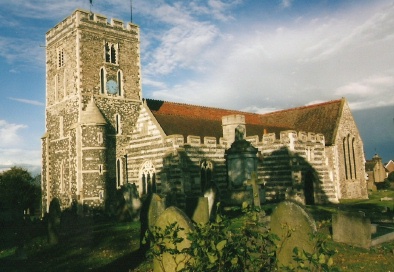
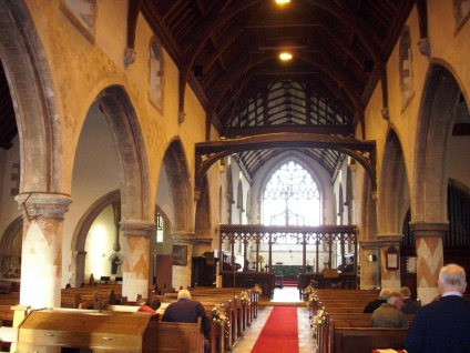
| Description | : | The Church at Cliffe is dedicated to St. Helen and bears the distinction of being the only church in Kent dedicated to that Saint. It stands in a prominent position at the edge of the Hoo peninsula overlooking the extensive marshes which at this point stretch some two miles to the Thames. The earliest undisputed documentary reference to a church at Cliffe is in the Domesday Book of 1086. The church is one of the largest in Kent. The monuments in the church are few and call for little comment. In the floor at the west end of the north... Read More |
frequently asked questions (FAQ):
-
Where is Saint Helen Churchyard?
Saint Helen Churchyard is located at Church Street Cliffe, Medway Unitary Authority ,Kent , ME3 7QEEngland.
-
Saint Helen Churchyard cemetery's updated grave count on graveviews.com?
55 memorials
-
Where are the coordinates of the Saint Helen Churchyard?
Latitude: 51.4619600
Longitude: 0.4975900
Nearby Cemetories:
1. St James Churchyard
Cooling, Medway Unitary Authority, England
Coordinate: 51.4552650, 0.5264000
2. St Mary Churchyard
Higham, Gravesham Borough, England
Coordinate: 51.4408760, 0.4682570
3. St Margaret Churchyard
High Halstow, Medway Unitary Authority, England
Coordinate: 51.4485130, 0.5598870
4. St. Catherine's Churchyard
East Tilbury, Thurrock Unitary Authority, England
Coordinate: 51.4664730, 0.4303230
5. St John Evangelist Churchyard
Higham, Gravesham Borough, England
Coordinate: 51.4162102, 0.4616890
6. St Philip and St James Churchyard
Upnor, Medway Unitary Authority, England
Coordinate: 51.4106250, 0.5250480
7. St Mary the Virgin Churchyard
Chalk, Gravesham Borough, England
Coordinate: 51.4265213, 0.4195510
8. St. Werburgh Churchyard
Hoo St Werburgh, Medway Unitary Authority, England
Coordinate: 51.4176500, 0.5634340
9. St Mary Churchyard
St Mary Hoo, Medway Unitary Authority, England
Coordinate: 51.4595390, 0.5948850
10. St John the Baptist Churchyard
Mucking, Thurrock Unitary Authority, England
Coordinate: 51.5044510, 0.4268880
11. All Saints Churchyard
Frindsbury, Medway Unitary Authority, England
Coordinate: 51.4004440, 0.5058970
12. Linford Methodist Churchyard
Linford, Thurrock Unitary Authority, England
Coordinate: 51.4908160, 0.4087900
13. Stanford-le-Hope Cemetery
Stanford-le-Hope, Thurrock Unitary Authority, England
Coordinate: 51.5104870, 0.4313190
14. St. Mary the Virgin Churchyard
Corringham, Thurrock Unitary Authority, England
Coordinate: 51.5225460, 0.4631320
15. St Peter and St Paul Churchyard
Shorne, Gravesham Borough, England
Coordinate: 51.4132347, 0.4297970
16. St Nicholas with St Mary Churchyard
Strood, Medway Unitary Authority, England
Coordinate: 51.3959790, 0.4931350
17. St Michael Churchyard
Fobbing, Thurrock Unitary Authority, England
Coordinate: 51.5278690, 0.4752220
18. St James Churchyard
West Tilbury, Thurrock Unitary Authority, England
Coordinate: 51.4739320, 0.3908730
19. Corringham Cemetery
Corringham, Thurrock Unitary Authority, England
Coordinate: 51.5268450, 0.4651920
20. St George Churchyard
Chatham, Medway Unitary Authority, England
Coordinate: 51.3974070, 0.5346770
21. St. Margaret's Churchyard
Stanford-le-Hope, Thurrock Unitary Authority, England
Coordinate: 51.5141520, 0.4260190
22. Willow Cemetery
Canvey Island, Castle Point Borough, England
Coordinate: 51.5250060, 0.5440810
23. Milton-next-Gravesend War Memorial
Gravesend, Gravesham Borough, England
Coordinate: 51.4389950, 0.3896110
24. St. Katherine Churchyard
Canvey Island, Castle Point Borough, England
Coordinate: 51.5207340, 0.5626850