
| Memorials | : | 37 |
| Location | : | Kenn, North Somerset Unitary Authority, England |
| Coordinate | : | 51.4168000, -2.8413000 |
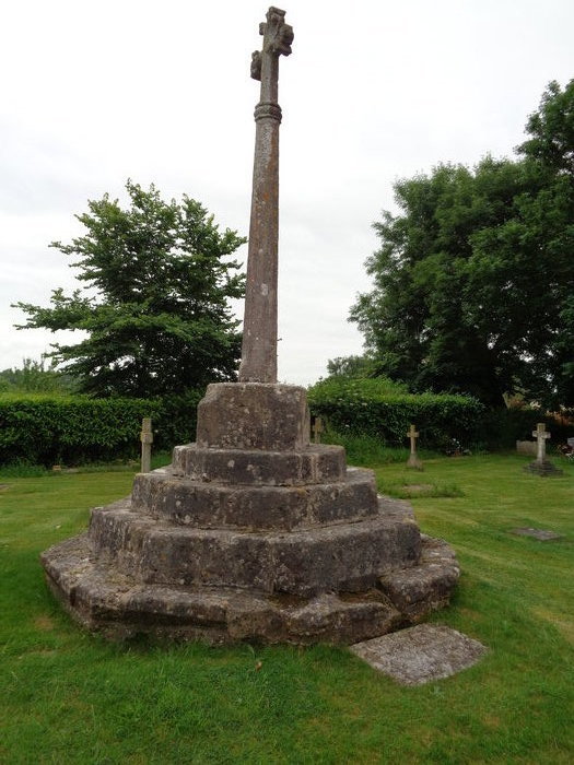
| Description | : | Located on the south side of Kenn Street, near the B3133 Kenn Road junction. Tower of Norman origin, with later additions, the church was largely rebuilt and restored in the 19th century. The church is surrounded by a small square churchyard containing a 14th century cross which was restored as a war memorial after WW1. |
frequently asked questions (FAQ):
-
Where is Saint John the Evangelist Churchyard?
Saint John the Evangelist Churchyard is located at Kenn, North Somerset Unitary Authority ,Somerset ,England.
-
Saint John the Evangelist Churchyard cemetery's updated grave count on graveviews.com?
35 memorials
-
Where are the coordinates of the Saint John the Evangelist Churchyard?
Latitude: 51.4168000
Longitude: -2.8413000

Nearby Cemetories:
1. All Saints Churchyard
Kingston Seymour, North Somerset Unitary Authority, England
Coordinate: 51.3974392, -2.8627201
2. All Saints Churchyard
Clevedon, North Somerset Unitary Authority, England
Coordinate: 51.4427000, -2.8406000
3. St Andrew Churchyard
Clevedon, North Somerset Unitary Authority, England
Coordinate: 51.4331670, -2.8735760
4. Clevedon Cemetery
Clevedon, North Somerset Unitary Authority, England
Coordinate: 51.4322600, -2.8747270
5. St. Mary's Churchyard
Clevedon, North Somerset Unitary Authority, England
Coordinate: 51.4495200, -2.8514000
6. St. Mary's Churchyard
Yatton, North Somerset Unitary Authority, England
Coordinate: 51.3847720, -2.8185510
7. Yatton Parish Council Burial Grounds
Yatton, North Somerset Unitary Authority, England
Coordinate: 51.3840541, -2.8182519
8. St. Paul's Churchyard
Walton-in-Gordano, North Somerset Unitary Authority, England
Coordinate: 51.4542810, -2.8287060
9. Ss Quiricus & Julietta Churchyard
Tickenham, North Somerset Unitary Authority, England
Coordinate: 51.4394000, -2.7814000
10. Saint Bridget's Churchyard
Chelvey, North Somerset Unitary Authority, England
Coordinate: 51.4117570, -2.7689680
11. St Anne's Church Hewish
Weston-super-Mare, North Somerset Unitary Authority, England
Coordinate: 51.3740520, -2.8666300
12. Holy Trinity Churchyard
Nailsea, North Somerset Unitary Authority, England
Coordinate: 51.4258140, -2.7692830
13. Holy Trinity Churchyard
Cleeve, North Somerset Unitary Authority, England
Coordinate: 51.3908200, -2.7773600
14. St. Nicholas' Churchyard
Brockley, North Somerset Unitary Authority, England
Coordinate: 51.3988950, -2.7686830
15. St Andrew Churchyard
Congresbury, North Somerset Unitary Authority, England
Coordinate: 51.3701100, -2.8121320
16. Holy Saviour Churchyard
Puxton, North Somerset Unitary Authority, England
Coordinate: 51.3652680, -2.8536510
17. Christ Church Churchyard
Nailsea, North Somerset Unitary Authority, England
Coordinate: 51.4336490, -2.7612050
18. Nailsea Garden of Rest
Nailsea, North Somerset Unitary Authority, England
Coordinate: 51.4340540, -2.7613880
19. St Peter & St Paul Churchyard
Weston-in-Gordano, North Somerset Unitary Authority, England
Coordinate: 51.4642080, -2.8017420
20. Wick St. Lawrence Churchyard
Wick St Lawrence, North Somerset Unitary Authority, England
Coordinate: 51.3844000, -2.9117000
21. Saint Michael Churchyard
Clapton-in-Gordano, North Somerset Unitary Authority, England
Coordinate: 51.4583000, -2.7673000
22. Portishead Cemetery
Portishead, North Somerset Unitary Authority, England
Coordinate: 51.4720380, -2.7737220
23. St. Andrew's Churchyard
Backwell, North Somerset Unitary Authority, England
Coordinate: 51.4118600, -2.7297400
24. Ebdon Road Crematorium and Cemetery
Weston-super-Mare, North Somerset Unitary Authority, England
Coordinate: 51.3707090, -2.9254530