
| Memorials | : | 6 |
| Location | : | West Point, King William County, USA |
| Phone | : | 804-843-9194 |
| Website | : | www.oldstjohns.org/ |
| Coordinate | : | 37.6161694, -76.9212737 |
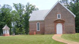
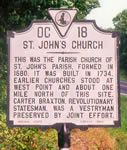
| Description | : | St. John's Church is a historic Episcopal church located near Sweet Hall, King William County, Virginia, United States. It was constructed in 1734 and is a one-story, "T"-shaped brick building. It measures 50 feet, 3 inches, by 20 feet, 2 inches, with a 24 feet wide, 28 feet, 9 inch, wing. St. John's is the only surviving colonial church in King William County to remain in the Episcopal charge. This church is also important in that it is associated with Carter Braxton, Signer of the Declaration of Independence, who regularly attended worship there.[3] It was listed on the National Register of... Read More |
frequently asked questions (FAQ):
-
Where is Saint Johns Church Cemetery?
Saint Johns Church Cemetery is located at 103 St. John West Point, King William County ,Virginia , 23181USA.
-
Saint Johns Church Cemetery cemetery's updated grave count on graveviews.com?
6 memorials
-
Where are the coordinates of the Saint Johns Church Cemetery?
Latitude: 37.6161694
Longitude: -76.9212737
Nearby Cemetories:
1. Bethany Baptist Church Cemetery
King William County, USA
Coordinate: 37.6095730, -76.9281000
2. Trinity Baptist Church Cemetery
West Point, King William County, USA
Coordinate: 37.6351250, -76.9309950
3. Brett Reed Presbyterian Church Cemetery
West Point, King William County, USA
Coordinate: 37.5913010, -76.8940964
4. Mattaponi Indian Reservation Baptist Cemetery
West Point, King William County, USA
Coordinate: 37.6620273, -76.9136790
5. Sweet Hall Cemetery
King William County, USA
Coordinate: 37.5700360, -76.9037120
6. Colosse Cemetery
West Point, King William County, USA
Coordinate: 37.6585680, -76.9510897
7. Lanesville Cemetery
King William County, USA
Coordinate: 37.6101390, -76.9838610
8. Union Hope Baptist Church Cemetery
King William, King William County, USA
Coordinate: 37.6101830, -76.9977670
9. Immanuel Chapel Episcopal Church Cemetery
King and Queen County, USA
Coordinate: 37.6706908, -76.8781389
10. Union Hope Baptist Church Cemetery
Ino, King and Queen County, USA
Coordinate: 37.5997600, -77.0016000
11. Old Town Farm
King William County, USA
Coordinate: 37.5864760, -76.9974970
12. Ephesus Baptist Church Cemetery
West Point, King William County, USA
Coordinate: 37.5790700, -76.8454120
13. Jerusalem Christian Church Cemetery
King William, King William County, USA
Coordinate: 37.6546616, -77.0011203
14. Pamunkey Indian Reservation
King William, King William County, USA
Coordinate: 37.5747220, -77.0013890
15. Pamunkey Indian Baptist Church Cemetery
King William, King William County, USA
Coordinate: 37.5749910, -77.0073300
16. Winchester Memorial Cemetery
King William County, USA
Coordinate: 37.5956120, -77.0203570
17. King William Wesleyan Methodist Church Cemetery
West Point, King William County, USA
Coordinate: 37.6753960, -76.9952425
18. Pace Chapel Methodist Church Cemetery
King and Queen Court House, King and Queen County, USA
Coordinate: 37.6883340, -76.8531580
19. Elsing Green Plantation
King William County, USA
Coordinate: 37.6160800, -77.0407300
20. Second Elam Baptist Church Cemetery
Lanexa, New Kent County, USA
Coordinate: 37.5225650, -76.8999570
21. Saint James Presbyterian Church Cemetery
King William, King William County, USA
Coordinate: 37.6851006, -77.0112000
22. New Elam Baptist Church Cemetery
New Kent, New Kent County, USA
Coordinate: 37.5236910, -76.9704920
23. Mount Olive Baptist Church Cemetery
King William, King William County, USA
Coordinate: 37.6338800, -77.0473100
24. New Kent Chapel Cemetery
Lanexa, New Kent County, USA
Coordinate: 37.5173250, -76.9534180