
| Memorials | : | 0 |
| Location | : | Pocahontas, Cape Girardeau County, USA |
| Coordinate | : | 37.5048256, -89.6079254 |
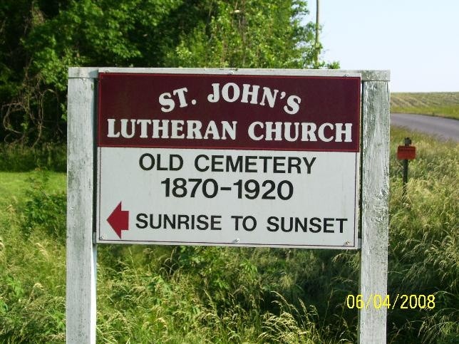
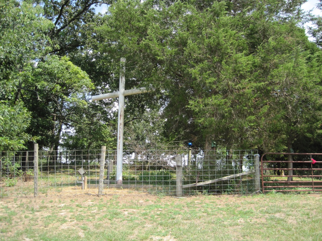
| Description | : | Located one mile east of Pocahontas, Missouri, this cemetery was used by St. John's Lutheran in Pocahontas from 1870-1895. It is located on land once owned by Joseph Pilz. |
frequently asked questions (FAQ):
-
Where is Saint Johns Lutheran Church Cemetery Old?
Saint Johns Lutheran Church Cemetery Old is located at Pocahontas, Cape Girardeau County ,Missouri ,USA.
-
Saint Johns Lutheran Church Cemetery Old cemetery's updated grave count on graveviews.com?
0 memorials
-
Where are the coordinates of the Saint Johns Lutheran Church Cemetery Old?
Latitude: 37.5048256
Longitude: -89.6079254
Nearby Cemetories:
1. Apple Creek Cemetery
Pocahontas, Cape Girardeau County, USA
Coordinate: 37.4989014, -89.6283035
2. New Bethel Baptist Church Cemetery
Jackson, Cape Girardeau County, USA
Coordinate: 37.5175514, -89.5870438
3. Draby Cemetery
Cape Girardeau County, USA
Coordinate: 37.4817100, -89.6073200
4. Darby Cemetery
Leemon, Cape Girardeau County, USA
Coordinate: 37.4816300, -89.6072800
5. St. John's Lutheran Church Cemetery New
Pocahontas, Cape Girardeau County, USA
Coordinate: 37.5015030, -89.6374512
6. Zion Lutheran Cemetery
Pocahontas, Cape Girardeau County, USA
Coordinate: 37.5011900, -89.6423800
7. Fleming Cemetery
New Wells, Cape Girardeau County, USA
Coordinate: 37.5355500, -89.6111100
8. New Jerusalem Cemetery
Pocahontas, Cape Girardeau County, USA
Coordinate: 37.5324969, -89.6337600
9. Old Shiloh Cemetery
Pocahontas, Cape Girardeau County, USA
Coordinate: 37.4786100, -89.6424000
10. Immanuel Lutheran Cemetery
New Wells, Cape Girardeau County, USA
Coordinate: 37.5473080, -89.6279210
11. Immanuel Lutheran Cemetery Old
New Wells, Cape Girardeau County, USA
Coordinate: 37.5563200, -89.6252260
12. Pleasant Hill Cemetery
Fruitland, Cape Girardeau County, USA
Coordinate: 37.4522705, -89.6278763
13. Trinity Lutheran Cemetery
Shawneetown, Cape Girardeau County, USA
Coordinate: 37.5488100, -89.6532500
14. High Hill Cemetery
Pocahontas, Cape Girardeau County, USA
Coordinate: 37.5389500, -89.5457500
15. Russell Cemetery
Cape Girardeau County, USA
Coordinate: 37.4432983, -89.6667023
16. McLain's Chapel Cemetery
Oriole, Cape Girardeau County, USA
Coordinate: 37.4536800, -89.5306600
17. Saint Johns United Church of Christ Cemetery
Fruitland, Cape Girardeau County, USA
Coordinate: 37.4549828, -89.6870270
18. Ware Cemetery
Cape Girardeau County, USA
Coordinate: 37.4278690, -89.6410480
19. Wilson Cemetery
Oak Ridge, Cape Girardeau County, USA
Coordinate: 37.5083000, -89.7136900
20. Goshen Cemetery
Oak Ridge, Cape Girardeau County, USA
Coordinate: 37.5226600, -89.7243800
21. Oak Ridge Cemetery
Oak Ridge, Cape Girardeau County, USA
Coordinate: 37.5019151, -89.7322832
22. Wheeler Cemetery
Cape Girardeau County, USA
Coordinate: 37.4639015, -89.7256012
23. Noland Cemetery
Cape Girardeau County, USA
Coordinate: 37.4354200, -89.5082800
24. Iona Cemetery
Cape Girardeau County, USA
Coordinate: 37.4403000, -89.5021973