| Memorials | : | 0 |
| Location | : | Compton Abbas, North Dorset District, England |
| Coordinate | : | 50.9654160, -2.1880250 |
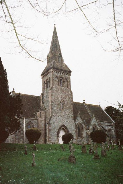
| Description | : | The current church building at Compton Abbas is Victorian, designed by George Evans of Wimborne, 1866-67. It replaced an older medieval church, whose tower still stands amongst the remains of the old churchyard a mile to the east. |
frequently asked questions (FAQ):
-
Where is Saint Mary the Virgin Churchyard?
Saint Mary the Virgin Churchyard is located at Compton Abbas, North Dorset District ,Dorset ,England.
-
Saint Mary the Virgin Churchyard cemetery's updated grave count on graveviews.com?
0 memorials
-
Where are the coordinates of the Saint Mary the Virgin Churchyard?
Latitude: 50.9654160
Longitude: -2.1880250
Nearby Cemetories:
1. St Andrew's Churchyard
Fontmell Magna, North Dorset District, England
Coordinate: 50.9521800, -2.1929100
2. St Thomas Churchyard
Melbury Abbas, North Dorset District, England
Coordinate: 50.9799490, -2.1694830
3. St Bartholomew's Churchyard
Sutton Waldron, North Dorset District, England
Coordinate: 50.9406250, -2.1979240
4. St. Thomas Churchyard
East Orchard, North Dorset District, England
Coordinate: 50.9605010, -2.2386630
5. St James Churchyard
Shaftesbury, North Dorset District, England
Coordinate: 51.0007100, -2.2037560
6. Saint Mary's Churchyard
Iwerne Minster, North Dorset District, England
Coordinate: 50.9286300, -2.1923800
7. St. Rumbold Churchyard
Cann, North Dorset District, England
Coordinate: 51.0036070, -2.1904180
8. Saint Nicholas' Church
Ashmore, North Dorset District, England
Coordinate: 50.9592570, -2.1272830
9. Shaftesbury Cemetery
Shaftesbury, North Dorset District, England
Coordinate: 51.0050660, -2.1834550
10. Shaftesbury Abbey Ruins
Shaftesbury, North Dorset District, England
Coordinate: 51.0053000, -2.1986000
11. St Peter's Church
Shaftesbury, North Dorset District, England
Coordinate: 51.0057190, -2.1967650
12. Holy Trinity Churchyard
Shaftesbury, North Dorset District, England
Coordinate: 51.0058250, -2.1994730
13. St Margaret Churchyard
Margaret Marsh, North Dorset District, England
Coordinate: 50.9668372, -2.2548074
14. St John's Churchyard
Motcombe, North Dorset District, England
Coordinate: 51.0073350, -2.2083450
15. St Luke’s Church
West Orchard, North Dorset District, England
Coordinate: 50.9470000, -2.2522300
16. St John's Churchyard and Cemetery
Donhead St Mary, Wiltshire Unitary Authority, England
Coordinate: 51.0028000, -2.1413417
17. All Saints Churchyard
North Dorset District, England
Coordinate: 50.9894410, -2.2541640
18. St. Mary's Churchyard
Iwerne Courtney, North Dorset District, England
Coordinate: 50.9112120, -2.2002710
19. St Nicholas' Churchyard
Manston, North Dorset District, England
Coordinate: 50.9347400, -2.2627530
20. St. Nicholas Churchyard
Child Okeford, North Dorset District, England
Coordinate: 50.9139200, -2.2353100
21. St. Mary's Churchyard
Donhead St Mary, Wiltshire Unitary Authority, England
Coordinate: 51.0190000, -2.1343080
22. St. Mary's Churchyard
Motcombe, North Dorset District, England
Coordinate: 51.0263000, -2.2165000
23. St Andrew's Churchyard
Todber, North Dorset District, England
Coordinate: 50.9794600, -2.2863750
24. St Michael and All Angels Churchyard
Hanford, North Dorset District, England
Coordinate: 50.8997690, -2.2210060

