
| Memorials | : | 4 |
| Location | : | Avondale, Auckland Council, New Zealand |
| Coordinate | : | -36.8994510, 174.6966690 |
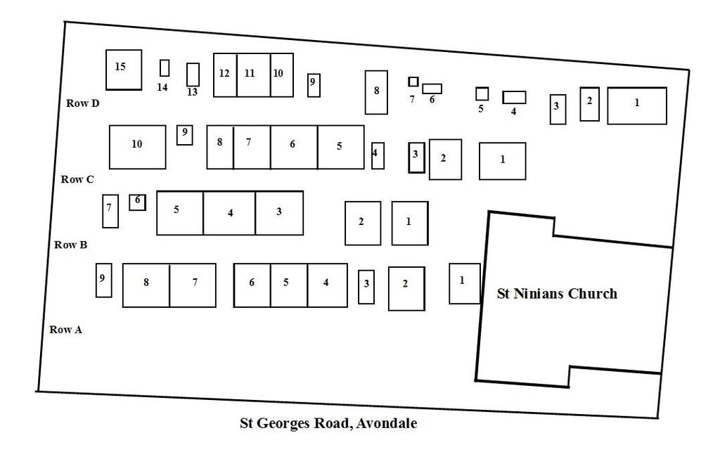
| Description | : | Saint Ninians Cemetery, the forgotten third historical cemetery on the Auckland City isthmus. The earliest burial was in July 1873, for Rev. David Hamilton who died from exposure and drowning in the Waitakere Ranges on his way to Presbyterian services in Huia and Whatipu. The latest burial was in 1974, according to the Society of Genealogists. It is Avondale's second cemetery after that at Rosebank (first burial there in 1862, and that one is still operational as the George Maxwell Memorial Cemetery, administered by the St Jude's Church Vestry.) Is it owned by Auckland City Council since the late 1980s,... Read More |
frequently asked questions (FAQ):
-
Where is Saint Ninians Churchyard?
Saint Ninians Churchyard is located at 26 St Georges Street Avondale, Auckland Council ,Auckland ,New Zealand.
-
Saint Ninians Churchyard cemetery's updated grave count on graveviews.com?
4 memorials
-
Where are the coordinates of the Saint Ninians Churchyard?
Latitude: -36.8994510
Longitude: 174.6966690

Nearby Cemetories:
1. George Maxwell Memorial Cemetery
Avondale, Auckland Council, New Zealand
Coordinate: -36.8890320, 174.6849320
2. St. Luke's Anglican Church Cemetery
Mount Albert, Auckland Council, New Zealand
Coordinate: -36.8785540, 174.7290400
3. Auckland Provincial Memorial
Glen Eden, Auckland Council, New Zealand
Coordinate: -36.9020700, 174.6548500
4. Waikumete Cemetery & Crematorium
Glen Eden, Auckland Council, New Zealand
Coordinate: -36.9025130, 174.6539610
5. Hillsborough Cemetery
Hillsborough, Auckland Council, New Zealand
Coordinate: -36.9246600, 174.7524030
6. Saint Andrew's Churchyard
Epsom, Auckland Council, New Zealand
Coordinate: -36.8937200, 174.7654100
7. Oratia Cemetery
Oratia, Auckland Council, New Zealand
Coordinate: -36.9108800, 174.6218900
8. Settlers Cemetery
Oratia, Auckland Council, New Zealand
Coordinate: -36.9108770, 174.6218870
9. Mount Eden Stockade Cemetery
Mount Eden, Auckland Council, New Zealand
Coordinate: -36.8678370, 174.7666430
10. Symonds Street Cemetery
Auckland, Auckland Council, New Zealand
Coordinate: -36.8582828, 174.7636628
11. Oratia Combined Church Cemetery
Oratia, Auckland Council, New Zealand
Coordinate: -36.9196396, 174.6119362
12. St Mark's Anglican Church Cemetery
Remuera, Auckland Council, New Zealand
Coordinate: -36.8729300, 174.7801600
13. St. Peter's Anglican Cemetery
Ōnehunga, Auckland Council, New Zealand
Coordinate: -36.9227113, 174.7847550
14. Our Lady of the Assumption Catholic Church
Ōnehunga, Auckland Council, New Zealand
Coordinate: -36.9223690, 174.7884530
15. Onehunga Catholic Cemetery
Ōnehunga, Auckland Council, New Zealand
Coordinate: -36.9224360, 174.7884560
16. Mangere Piriti Urupā St. James Churchyard
Mangere, Auckland Council, New Zealand
Coordinate: -36.9418970, 174.7835260
17. Waikaraka Cemetery
Ōnehunga, Auckland Council, New Zealand
Coordinate: -36.9297140, 174.7967170
18. St. Stephen's Churchyard
Auckland, Auckland Council, New Zealand
Coordinate: -36.8504860, 174.7899970
19. Swanson Cemetery
Swanson, Auckland Council, New Zealand
Coordinate: -36.8718400, 174.5836200
20. Mangere Lawn Cemetery
Mangere, Auckland Council, New Zealand
Coordinate: -36.9626150, 174.7857000
21. Pompallier Cemetery
Birkenhead, Auckland Council, New Zealand
Coordinate: -36.8036900, 174.7251200
22. Royal New Zealand Navy Memorial
Devonport, Auckland Council, New Zealand
Coordinate: -36.8305900, 174.7898900
23. Birkenhead-Glenfield Cemetery
Birkenhead, Auckland Council, New Zealand
Coordinate: -36.7989000, 174.7234700
24. Hobsonville Church and Settlers' Cemetery
Hobsonville, Auckland Council, New Zealand
Coordinate: -36.8000500, 174.6551800