
| Memorials | : | 0 |
| Location | : | Cole Camp, Benton County, USA |
| Coordinate | : | 38.4563300, -93.2036200 |
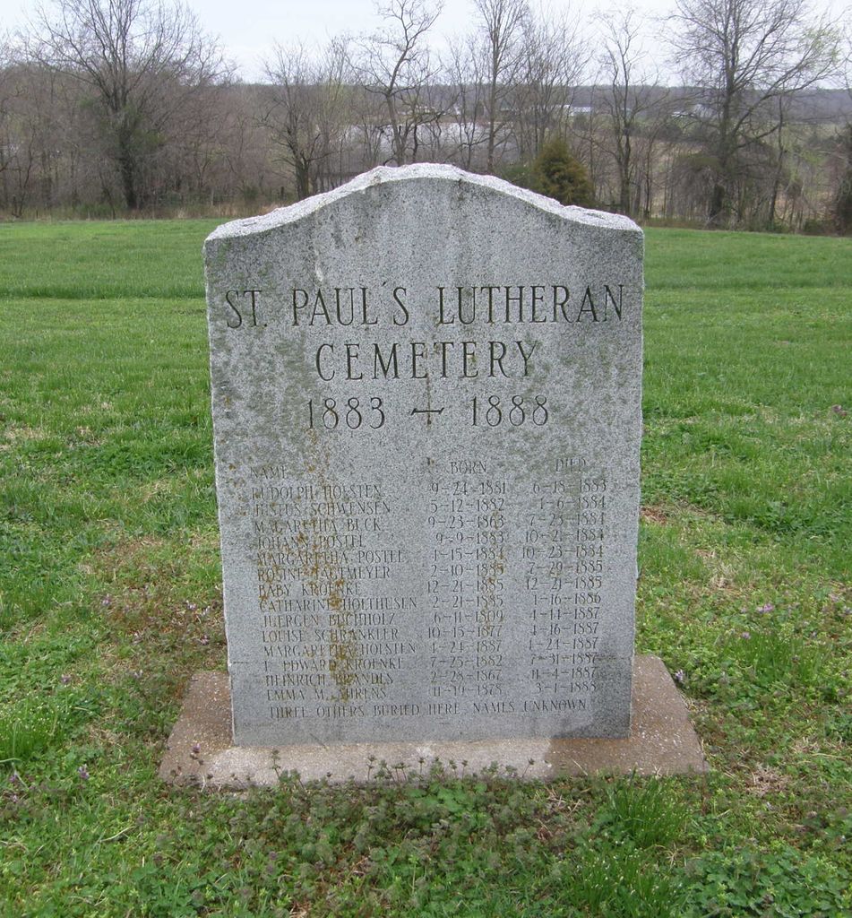
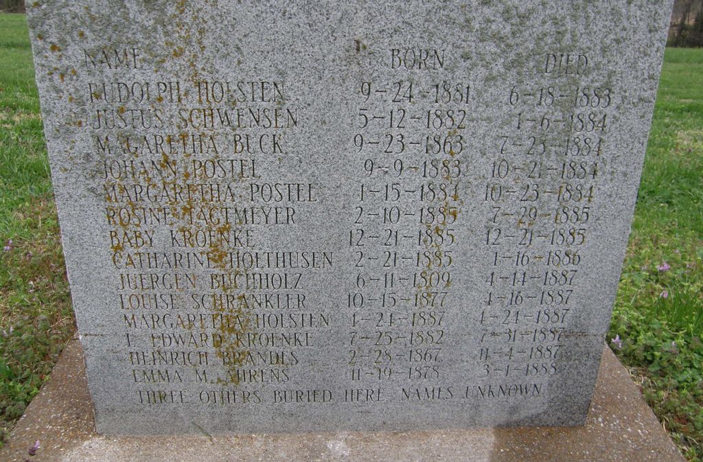
| Description | : | Located behind the church on West Grove St. These deaths are also listed in records of Brauersville Lutheran Church NE of Cole Camp, whose pastor then served both congregations. Only five original gravestones now remain. This is the original St Paul's cemetery used 1883-1888 and replaced by the present St Paul's Cemetery north of town on Hwy U. |
frequently asked questions (FAQ):
-
Where is Saint Pauls Lutheran Cemetery Original?
Saint Pauls Lutheran Cemetery Original is located at Cole Camp, Benton County ,Missouri ,USA.
-
Saint Pauls Lutheran Cemetery Original cemetery's updated grave count on graveviews.com?
0 memorials
-
Where are the coordinates of the Saint Pauls Lutheran Cemetery Original?
Latitude: 38.4563300
Longitude: -93.2036200
Nearby Cemetories:
1. Cole Camp Cemetery Original
Cole Camp, Benton County, USA
Coordinate: 38.4585500, -93.2020500
2. Saints Peter and Paul Catholic Cemetery
Cole Camp, Benton County, USA
Coordinate: 38.4551200, -93.1979900
3. First Baptist Cemetery
Cole Camp, Benton County, USA
Coordinate: 38.4506000, -93.2135300
4. Saint Pauls Lutheran Cemetery
Cole Camp, Benton County, USA
Coordinate: 38.4681015, -93.2007980
5. Cole Camp Memorial Cemetery
Cole Camp, Benton County, USA
Coordinate: 38.4692001, -93.2007980
6. Eickhoff Cemetery
Cole Camp, Benton County, USA
Coordinate: 38.4707600, -93.2017300
7. Trinity Lutheran Cemetery
Cole Camp, Benton County, USA
Coordinate: 38.4714012, -93.2018967
8. Eastwood Cemetery
Cole Camp, Benton County, USA
Coordinate: 38.4624800, -93.2229600
9. Cole Camp Cemetery
Cole Camp, Benton County, USA
Coordinate: 38.4594002, -93.2260971
10. Union-Williams Cemetery
Cole Camp, Benton County, USA
Coordinate: 38.4264000, -93.2329800
11. Immanuel Lutheran Cemetery
Benton County, USA
Coordinate: 38.4308014, -93.1556015
12. Kerber Family Farm Cemetery
Cole Camp, Benton County, USA
Coordinate: 38.4438200, -93.2717500
13. Saint Johns Lutheran Cemetery
Cole Camp, Benton County, USA
Coordinate: 38.4981150, -93.2495790
14. Mount Olivet Church Cemetery
Cole Camp, Benton County, USA
Coordinate: 38.4416900, -93.2770200
15. Brauersville Immanuel Lutheran Cemetery
Cole Camp, Benton County, USA
Coordinate: 38.4677400, -93.1198600
16. Bethlehem Cemetery
Benton County, USA
Coordinate: 38.4225600, -93.1137700
17. Tyree Family Cemetery
Cole Camp, Benton County, USA
Coordinate: 38.3889660, -93.2601070
18. Holy Cross Cemetery First
Cole Camp, Benton County, USA
Coordinate: 38.5014100, -93.1120600
19. Haw Creek Cemetery
Benton County, USA
Coordinate: 38.4431400, -93.0961300
20. Old Harryman Farm Graveyard
Benton County, USA
Coordinate: 38.3765200, -93.2504200
21. Holy Cross Cemetery
Cole Camp, Benton County, USA
Coordinate: 38.5052986, -93.1007996
22. Mount Hulda Lutheran Cemetery
Cole Camp, Benton County, USA
Coordinate: 38.3612100, -93.1805000
23. Chehaski Cemetery
Benton County, USA
Coordinate: 38.3656006, -93.2491989
24. Anton Balke Cemetery
Benton County, USA
Coordinate: 38.3988600, -93.0983800