
| Memorials | : | 31 |
| Location | : | Monroe, Monroe County, USA |
| Coordinate | : | 41.8863983, -83.4403000 |
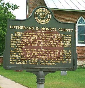
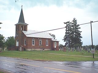
| Description | : | The cemetery and church are located on West Albain Road, 1/4 mile west of Telegraph Road (US-24), in Monroe Township, Monroe County, Michigan The Historical Marker sign located near the Church and Cemetery reads: Lutherans In Monroe County German Pioneers who began settling this area in 1828 formed Monroe County's first Lutheran Church here in 1834. The Rev Friedrich Schmid became their first pastor, traveling by horse-back from Ann Arbor. The sprawling congregation incorporated as Zoar Church in 1838 and built a log church. Trinity and Zion Church in Monroe, Holy Ghost in Raisinville, and Immanuel in Ida all developed from Zoar by 1849.... Read More |
frequently asked questions (FAQ):
-
Where is Saint Pauls Lutheran Church Cemetery?
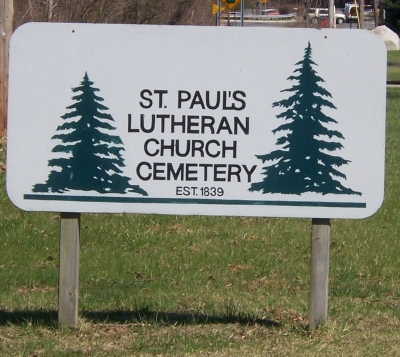
Saint Pauls Lutheran Church Cemetery is located at on West Albain Road, 1/4 mile west of Telegraph Road (US-24) Monroe, Monroe County ,Michigan ,USA.
-
Saint Pauls Lutheran Church Cemetery cemetery's updated grave count on graveviews.com?
31 memorials
-
Where are the coordinates of the Saint Pauls Lutheran Church Cemetery?
Latitude: 41.8863983
Longitude: -83.4403000
Nearby Cemetories:
1. Monroe Township Cemetery
Monroe, Monroe County, USA
Coordinate: 41.8872220, -83.4405550
2. Leonard Family Cemetery
La Salle, Monroe County, USA
Coordinate: 41.8744440, -83.4430550
3. Roselawn Memorial Park
La Salle, Monroe County, USA
Coordinate: 41.8605995, -83.4552994
4. La Salle Township Cemetery
La Salle, Monroe County, USA
Coordinate: 41.8602982, -83.4633026
5. Lutheran Home Cemetery
Monroe, Monroe County, USA
Coordinate: 41.9063650, -83.4064380
6. Memorial Place Cemetery
Monroe, Monroe County, USA
Coordinate: 41.9108370, -83.4025760
7. Potters Field Cemetery
Monroe, Monroe County, USA
Coordinate: 41.9180500, -83.4711100
8. Saint Antoine Cemetery
Monroe, Monroe County, USA
Coordinate: 41.9263800, -83.4304550
9. Woodland Cemetery
Monroe, Monroe County, USA
Coordinate: 41.9075012, -83.3925018
10. Trinity Lutheran Cemetery
Monroe, Monroe County, USA
Coordinate: 41.9069444, -83.3919444
11. Zion Lutheran Cemetery
Monroe, Monroe County, USA
Coordinate: 41.9071999, -83.3902969
12. Immaculate Heart of Mary Cemetery
Monroe, Monroe County, USA
Coordinate: 41.9206090, -83.4036330
13. Old Immanuel Lutheran Cemetery
Raisinville Township, Monroe County, USA
Coordinate: 41.9116550, -83.5015280
14. Old Burial Ground
Monroe, Monroe County, USA
Coordinate: 41.9259370, -83.3927540
15. Battlefield of Frenchtown Monument
Monroe, Monroe County, USA
Coordinate: 41.9136110, -83.3783330
16. Saint Joseph Cemetery
Monroe, Monroe County, USA
Coordinate: 41.9289017, -83.3921967
17. Saint Johns Catholic Cemetery
La Salle, Monroe County, USA
Coordinate: 41.8515960, -83.5035330
18. King Cemetery
Monroe, Monroe County, USA
Coordinate: 41.9411011, -83.5100021
19. Immanuel Cemetery
Ida, Monroe County, USA
Coordinate: 41.8966670, -83.5433330
20. Keeney Cemetery
Erie Township, Monroe County, USA
Coordinate: 41.8074989, -83.4966965
21. Richardson Cemetery
Ida Township, Monroe County, USA
Coordinate: 41.8572006, -83.5550003
22. Doty Cemetery
Monroe, Monroe County, USA
Coordinate: 41.9538994, -83.5252991
23. Neriah Cemetery
Ida Center, Monroe County, USA
Coordinate: 41.8241997, -83.5381012
24. Erie Union Cemetery
Erie, Monroe County, USA
Coordinate: 41.8130989, -83.5235977