
| Memorials | : | 0 |
| Location | : | Westphalia, Knox County, USA |
| Coordinate | : | 38.8665428, -87.2252426 |
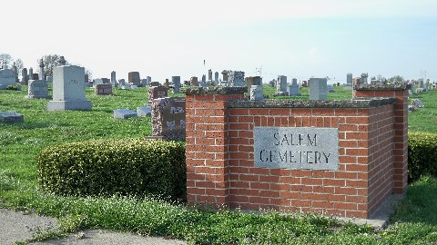
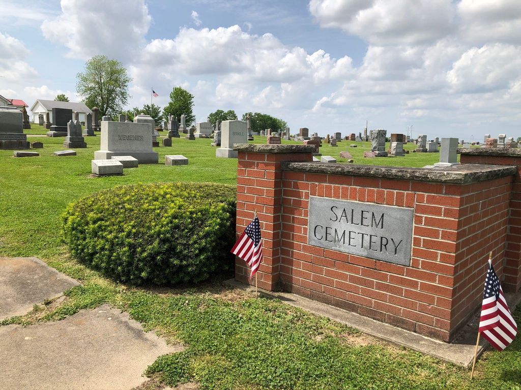
| Description | : | The cemetery is located in Vigo Township (E half of the SE quadrant of Section 18 Township 5N Range 7W) on the west side of Salem Street / 1st Street about 0.3 miles north of its intersection with Indiana State Highway 58 / Indiana State Highway 67. Indiana Cemetery Locations, Volume 1, published by the Indiana Genealogical Society (02 April 2005), gives the primary cemetery name as Westphalia Cemetery with an alternate name of Salem Cemetery. The cemetery is listed in the Cemetery and Burial Grounds Registry of the Indiana Department of Natural Resources (DNR) and in the... Read More |
frequently asked questions (FAQ):
-
Where is Salem Cemetery?
Salem Cemetery is located at Salem Street / 1st Street Westphalia, Knox County ,Indiana , 47578USA.
-
Salem Cemetery cemetery's updated grave count on graveviews.com?
0 memorials
-
Where are the coordinates of the Salem Cemetery?
Latitude: 38.8665428
Longitude: -87.2252426
Nearby Cemetories:
1. Begeman Cemetery
Knox County, USA
Coordinate: 38.8821983, -87.2347031
2. Kruger Cemetery
Edwardsport, Knox County, USA
Coordinate: 38.8690000, -87.2683000
3. Delay Cemetery
Sandborn, Knox County, USA
Coordinate: 38.8985400, -87.2048910
4. Old Bethel Evangelical Lutheran & Reformed Cemeter
Freelandville, Knox County, USA
Coordinate: 38.8585600, -87.2850300
5. Bethel Cemetery
Freelandville, Knox County, USA
Coordinate: 38.8633194, -87.2858734
6. George Schmitt Family Cemetery
Knox County, USA
Coordinate: 38.8496510, -87.2875570
7. Sandborn Cemetery
Sandborn, Knox County, USA
Coordinate: 38.8969002, -87.1697006
8. Bethel Cemetery
Marco, Greene County, USA
Coordinate: 38.9195680, -87.2166440
9. Smith Family Cemetery
Widner Township, Knox County, USA
Coordinate: 38.8461900, -87.2933100
10. Soliday Farm Cemetery
Sandborn, Knox County, USA
Coordinate: 38.8898000, -87.1568000
11. Freelandville Memorial Cemetery
Freelandville, Knox County, USA
Coordinate: 38.8672829, -87.3027649
12. Edwardsport Town Cemetery
Edwardsport, Knox County, USA
Coordinate: 38.8067398, -87.2503738
13. John Schroeder Farm Cemetery
Freelandville, Knox County, USA
Coordinate: 38.8768520, -87.3080920
14. Freelandville Christian Church Cemetery
Freelandville, Knox County, USA
Coordinate: 38.8679085, -87.3100815
15. John J. Stoelting Burial Site
Freelandville, Knox County, USA
Coordinate: 38.8588000, -87.3108000
16. IOOF Cemetery
Edwardsport, Knox County, USA
Coordinate: 38.7963982, -87.2593994
17. Cincinnati Cemetery
Plainville, Daviess County, USA
Coordinate: 38.8347000, -87.1375000
18. Douthit Family Cemetery
Sullivan County, USA
Coordinate: 38.9315640, -87.2882220
19. Stafford Cemetery
Greene County, USA
Coordinate: 38.9483620, -87.1865010
20. Plainville Cemetery
Plainville, Daviess County, USA
Coordinate: 38.7977982, -87.1532974
21. Taylor Graveyard
Odon, Daviess County, USA
Coordinate: 38.8289870, -87.1159350
22. Chambers Cemetery
Knox County, USA
Coordinate: 38.8314018, -87.3405991
23. Morris Cemetery
Summit, Greene County, USA
Coordinate: 38.9636000, -87.2267000
24. Pleasantville Cemetery
Pleasantville, Sullivan County, USA
Coordinate: 38.9651985, -87.2471008