
| Memorials | : | 0 |
| Location | : | Freelandville, Knox County, USA |
| Coordinate | : | 38.8585600, -87.2850300 |
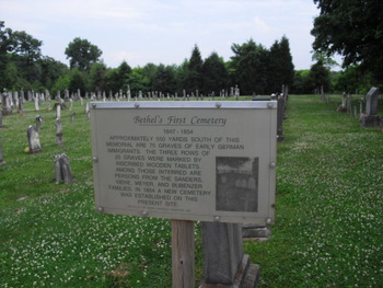
| Description | : | The Plaque in the EUB Church Cemetery reads: Property for this Cemetery was from Mr. Henry Volle, ca. 1847. It was located behind the parsonage, one fourth mile east of Church Road (CR 58.) Interments were made in rows and all had the same kind of wooden markers. The number of graves of the original settlers are reported to be seventy-five, in rows of twenty five each. This Cemetery was used from 1847 to 1854 before it was abandoned. Families known to have been buried here were: Sanders, Viehe, Meyer, and Bubenzer. From the "Schroeder and Sander Family Histories, by Clara... Read More |
frequently asked questions (FAQ):
-
Where is Old Bethel Evangelical Lutheran & Reformed Cemeter?
Old Bethel Evangelical Lutheran & Reformed Cemeter is located at Freelandville, Knox County ,Indiana ,USA.
-
Old Bethel Evangelical Lutheran & Reformed Cemeter cemetery's updated grave count on graveviews.com?
0 memorials
-
Where are the coordinates of the Old Bethel Evangelical Lutheran & Reformed Cemeter?
Latitude: 38.8585600
Longitude: -87.2850300
Nearby Cemetories:
1. Bethel Cemetery
Freelandville, Knox County, USA
Coordinate: 38.8633194, -87.2858734
2. George Schmitt Family Cemetery
Knox County, USA
Coordinate: 38.8496510, -87.2875570
3. Smith Family Cemetery
Widner Township, Knox County, USA
Coordinate: 38.8461900, -87.2933100
4. Freelandville Memorial Cemetery
Freelandville, Knox County, USA
Coordinate: 38.8672829, -87.3027649
5. Kruger Cemetery
Edwardsport, Knox County, USA
Coordinate: 38.8690000, -87.2683000
6. John J. Stoelting Burial Site
Freelandville, Knox County, USA
Coordinate: 38.8588000, -87.3108000
7. Freelandville Christian Church Cemetery
Freelandville, Knox County, USA
Coordinate: 38.8679085, -87.3100815
8. John Schroeder Farm Cemetery
Freelandville, Knox County, USA
Coordinate: 38.8768520, -87.3080920
9. Begeman Cemetery
Knox County, USA
Coordinate: 38.8821983, -87.2347031
10. Salem Cemetery
Westphalia, Knox County, USA
Coordinate: 38.8665428, -87.2252426
11. Chambers Cemetery
Knox County, USA
Coordinate: 38.8314018, -87.3405991
12. Edwardsport Town Cemetery
Edwardsport, Knox County, USA
Coordinate: 38.8067398, -87.2503738
13. Mariah Creek Baptist Church Cemetery
Oaktown, Knox County, USA
Coordinate: 38.8518570, -87.3635040
14. Walker Cemetery
Knox County, USA
Coordinate: 38.8600006, -87.3664017
15. IOOF Cemetery
Edwardsport, Knox County, USA
Coordinate: 38.7963982, -87.2593994
16. Douthit Family Cemetery
Sullivan County, USA
Coordinate: 38.9315640, -87.2882220
17. Delay Cemetery
Sandborn, Knox County, USA
Coordinate: 38.8985400, -87.2048910
18. Morris Chapel Cemetery
Knox County, USA
Coordinate: 38.8808937, -87.3774643
19. Mariah Creek Christian Church Cemetery
Oaktown, Knox County, USA
Coordinate: 38.8293991, -87.3758011
20. Bethel Cemetery
Marco, Greene County, USA
Coordinate: 38.9195680, -87.2166440
21. Light Cemetery
Oaktown, Knox County, USA
Coordinate: 38.8512260, -87.3934880
22. Bethlehem Cemetery
Carlisle, Sullivan County, USA
Coordinate: 38.9223175, -87.3588257
23. Martin-Thorne Cemetery
Knox County, USA
Coordinate: 38.8118000, -87.3834000
24. Indian Prairie Baptist Church Cemetery
Bucktown, Sullivan County, USA
Coordinate: 38.9479523, -87.3085327