
| Memorials | : | 0 |
| Location | : | Otley, Metropolitan Borough of Leeds, England |
| Coordinate | : | 53.9073370, -1.6939380 |
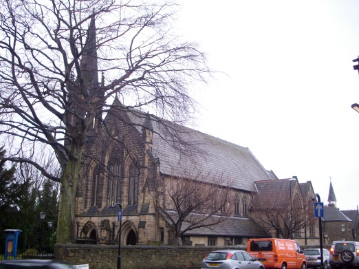
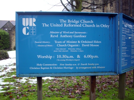
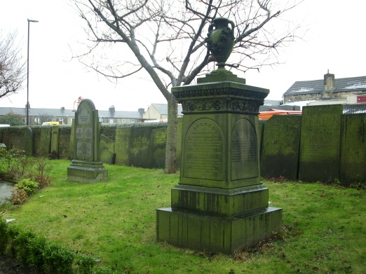
| Description | : | Salem Independent Congregational Chapel was built on this site in 1825. The church was renamed as The Bridge United Reformed Church in 1972 following unification of Congregational and Presbyterian churches in England. |
frequently asked questions (FAQ):
-
Where is Salem Independent Congregational Chapelyard?
Salem Independent Congregational Chapelyard is located at Bridge Street Otley, Metropolitan Borough of Leeds ,West Yorkshire , LS21 3AZEngland.
-
Salem Independent Congregational Chapelyard cemetery's updated grave count on graveviews.com?
0 memorials
-
Where are the coordinates of the Salem Independent Congregational Chapelyard?
Latitude: 53.9073370
Longitude: -1.6939380
Nearby Cemetories:
1. Our Lady and All Saints Catholic Church
Otley, Metropolitan Borough of Leeds, England
Coordinate: 53.9070200, -1.6940970
2. Otley Methodist Church War Memorial
Otley, Metropolitan Borough of Leeds, England
Coordinate: 53.9057130, -1.6906820
3. All Saints Churchyard
Otley, Metropolitan Borough of Leeds, England
Coordinate: 53.9040570, -1.6946780
4. Otley War Memorial
Otley, Metropolitan Borough of Leeds, England
Coordinate: 53.9041280, -1.6925650
5. Otley Cemetery
Otley, Metropolitan Borough of Leeds, England
Coordinate: 53.9074820, -1.6833890
6. All Saints Churchyard
Farnley, Harrogate Borough, England
Coordinate: 53.9281640, -1.6771760
7. All Saints Churchyard
Weston, Harrogate Borough, England
Coordinate: 53.9155840, -1.7318030
8. Guiseley Cemetery
Guiseley, Metropolitan Borough of Leeds, England
Coordinate: 53.8846820, -1.7192470
9. God's Acre Cemetery
Burley-in-Wharfedale, Metropolitan Borough of Bradford, England
Coordinate: 53.8996500, -1.7393000
10. St Mary Churchyard
Burley-in-Wharfedale, Metropolitan Borough of Bradford, England
Coordinate: 53.9124040, -1.7415660
11. High Royds Memorial Garden
Menston, Metropolitan Borough of Bradford, England
Coordinate: 53.8866100, -1.7283200
12. St. Oswald's Churchyard
Leathley, Harrogate Borough, England
Coordinate: 53.9187140, -1.6484470
13. Menston Cemetery
Menston, Metropolitan Borough of Bradford, England
Coordinate: 53.8858550, -1.7278460
14. St. Oswald's Churchyard
Guiseley, Metropolitan Borough of Leeds, England
Coordinate: 53.8751330, -1.7062080
15. St John the Divine Churchyard
Menston, Metropolitan Borough of Bradford, England
Coordinate: 53.8919500, -1.7455200
16. Friends Burial Ground at Asquith
Askwith, Harrogate Borough, England
Coordinate: 53.9272670, -1.7419150
17. Guiseley Primitive Methodist Chapelyard
Guiseley, Metropolitan Borough of Leeds, England
Coordinate: 53.8733790, -1.7119970
18. Yeadon Cemetery
Yeadon, Metropolitan Borough of Leeds, England
Coordinate: 53.8716080, -1.6751690
19. St Wilfrid Churchyard
Pool in Wharfdale, Metropolitan Borough of Leeds, England
Coordinate: 53.9023800, -1.6296080
20. Friends Burial Ground
Yeadon, Metropolitan Borough of Leeds, England
Coordinate: 53.8659722, -1.7047778
21. Wesleyan Burial Ground
Yeadon, Metropolitan Borough of Leeds, England
Coordinate: 53.8655770, -1.6852220
22. Puritan Chapelyard
Bramhope, Metropolitan Borough of Leeds, England
Coordinate: 53.8878420, -1.6227120
23. St John the Evangelist Churchyard
Yeadon, Metropolitan Borough of Leeds, England
Coordinate: 53.8610120, -1.6908590
24. St Giles Churchyard
Bramhope, Metropolitan Borough of Leeds, England
Coordinate: 53.8865500, -1.6226490