
| Memorials | : | 0 |
| Location | : | Scarboro, Jenkins County, USA |
| Coordinate | : | 32.7138700, -81.8768760 |
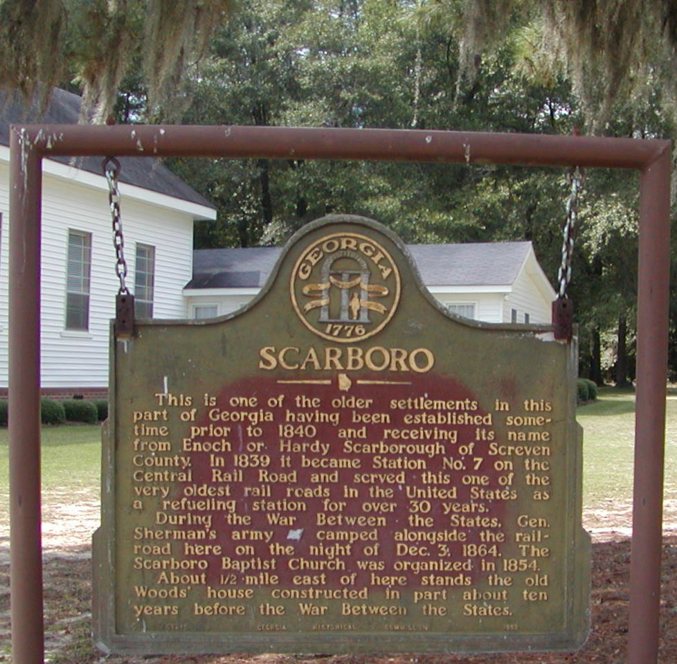
| Description | : | The Georgia Historical Commission erected a marker (082-5) at Scarboro in 1953: Scarboro - This is one of the older settlements in this part of Georgia having been established sometime prior to 1840 and receiving its name from Enoch or Hardy Scarborough of Screven County. In 1839 it became Station No. 7 on the Central Rail Road and served this one of the very oldest rail roads in the United States as a refueling station for over 30 years. During the War Between the States, Gen. Sherman's army camped alongside the rail-road here on the night of Dec. 3,... Read More |
frequently asked questions (FAQ):
-
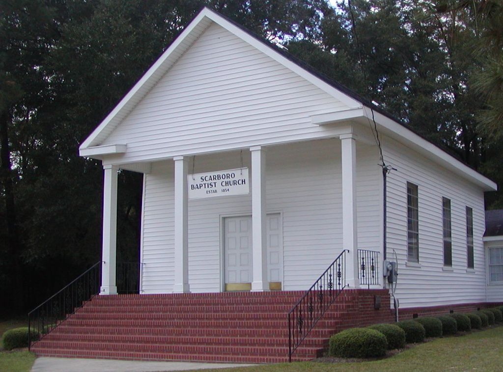
Where is Scarboro Baptist Church Cemetery?
Scarboro Baptist Church Cemetery is located at Scarboro, Jenkins County ,Georgia ,USA.
-
Scarboro Baptist Church Cemetery cemetery's updated grave count on graveviews.com?
0 memorials
-
Where are the coordinates of the Scarboro Baptist Church Cemetery?
Latitude: 32.7138700
Longitude: -81.8768760
Nearby Cemetories:
1. Scarboro Cemetery
Jenkins County, USA
Coordinate: 32.7118590, -81.8780910
2. Clifton Family Cemetery
Scarboro, Jenkins County, USA
Coordinate: 32.7318800, -81.8832100
3. Hurricane Branch Baptist Church Cemetery
Scarboro, Jenkins County, USA
Coordinate: 32.7377030, -81.8588360
4. Gordon Grove Baptist Church Cemetery
Millen, Jenkins County, USA
Coordinate: 32.6968460, -81.9170480
5. Gay Family Cemetery
Four Points, Jenkins County, USA
Coordinate: 32.7079800, -81.9339100
6. Brinson Rock Baptist Church Cemetery
Paramore Hill, Jenkins County, USA
Coordinate: 32.7631200, -81.8919600
7. Lanier Cemetery
Millen, Jenkins County, USA
Coordinate: 32.6657982, -81.8981018
8. Aycock Cemetery
Jenkins County, USA
Coordinate: 32.6800003, -81.9272003
9. Finch Cemetery
Jenkins County, USA
Coordinate: 32.6453018, -81.8636017
10. Longbranch Church of God Cemetery
Jenkins County, USA
Coordinate: 32.6762990, -81.9475540
11. Williams Grove Church of God In Christ Cemetery
Millen, Jenkins County, USA
Coordinate: 32.7001430, -81.9607870
12. Oak Hill Baptist Church Cemetery
Paramore Hill, Jenkins County, USA
Coordinate: 32.7875640, -81.8641540
13. Paynes Chapel United Methodist Church Cemetery
Millen, Jenkins County, USA
Coordinate: 32.6657982, -81.9460983
14. Johnson Family Cemetery
Emmalane, Jenkins County, USA
Coordinate: 32.7432390, -81.9674230
15. Daughtry Cemetery
Bulloch County, USA
Coordinate: 32.6375008, -81.8371964
16. Clifton Cemetery
Jenkins County, USA
Coordinate: 32.7033005, -81.9757996
17. Brinson Cemetery
Jenkins County, USA
Coordinate: 32.7857780, -81.9355560
18. Sand Hill Baptist Church Cemetery
Millen, Jenkins County, USA
Coordinate: 32.7966720, -81.8371150
19. Williams Cemetery
Jenkins County, USA
Coordinate: 32.6789017, -81.9756012
20. Daniel Grove Baptist Church
Millen, Jenkins County, USA
Coordinate: 32.7893400, -81.9367900
21. Lane Family Cemetery #2
Jenkins County, USA
Coordinate: 32.7033200, -81.9871500
22. Saunders Cemetery
Jenkins County, USA
Coordinate: 32.6377720, -81.9440940
23. Lane Family Cemetery #1
Emmalane, Jenkins County, USA
Coordinate: 32.7561100, -81.9841700
24. Oak Grove Baptist Church Cemetery
Portal, Bulloch County, USA
Coordinate: 32.6137790, -81.8678920