
| Memorials | : | 0 |
| Location | : | Nord-Fron, Nord-Fron kommune, Norway |
| Coordinate | : | 61.5885130, 9.7813620 |
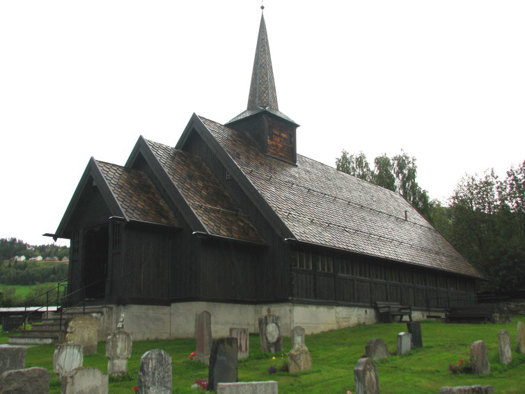
| Description | : | From Findagrave contributor Espa: The Sødorp Chapel is located on the former site of the Sødorp Church. The site of the Sødorp Chapel is different from the ancient site of the Sødorp Annex Church (which is approximately 61.59348 9.78744) and different from the current site of the Sødorp Church (which is 61.59917 9.73582). The Sødorp Church was built in 1752 or 1760 (sources differ) on the Litlgard (Lillegaard) farm, at the site of what is now the Sødorp Chapel. The Sødorp Church was moved to its present location, across Gudbrandsdalslågen, in 1908-10. The Sødorp Chapel was built in the church's former location in 1929. In the Sødorp... Read More |
frequently asked questions (FAQ):
-
Where is Sødorp Old Cemetery?
Sødorp Old Cemetery is located at Nord-Fron, Nord-Fron kommune ,Oppland fylke ,Norway.
-
Sødorp Old Cemetery cemetery's updated grave count on graveviews.com?
0 memorials
-
Where are the coordinates of the Sødorp Old Cemetery?
Latitude: 61.5885130
Longitude: 9.7813620
Nearby Cemetories:
1. Sødorp
Vinstra, Nord-Fron kommune, Norway
Coordinate: 61.5990900, 9.7360900
2. Sør Fron Cemetery
Hundorp, Sør-Fron kommune, Norway
Coordinate: 61.5586920, 9.9418070
3. Kvam Churchyard
Kvam, Nord-Fron kommune, Norway
Coordinate: 61.6654660, 9.6941910
4. Kvikne Churchyard
Nord-Fron, Nord-Fron kommune, Norway
Coordinate: 61.5744000, 9.5873500
5. Venabygd Churchyard
Venabygd, Ringebu kommune, Norway
Coordinate: 61.5928840, 10.0524460
6. Ringebu Cemetery
Ringebu, Ringebu kommune, Norway
Coordinate: 61.5090710, 10.1732530
7. Sel Kirke
Otta, Sel kommune, Norway
Coordinate: 61.8017900, 9.5524490
8. Faavang Kirke
Ringebu, Ringebu kommune, Norway
Coordinate: 61.4272450, 10.2197510
9. Heidal Churchyard
Otta, Sel kommune, Norway
Coordinate: 61.7473900, 9.3302700
10. Svatsum Cemetery
Vestre Gausdal, Gausdal kommune, Norway
Coordinate: 61.3193320, 9.8563950
11. Nord-Sel Churchyard
Sel kommune, Norway
Coordinate: 61.8496240, 9.4214310
12. Sollia kirke
Sollia, Stor-Elvdal kommune, Norway
Coordinate: 61.7804470, 10.4001850
13. Tretten Kirke
Tretten, Øyer kommune, Norway
Coordinate: 61.3170800, 10.3053470
14. Østre Gausdal Cemetery
Gausdal kommune, Norway
Coordinate: 61.2573900, 10.1552000
15. Vestre Gausdal Cemetery
Vestre Gausdal, Gausdal kommune, Norway
Coordinate: 61.2005670, 10.1470830
16. Follebu kirkegård
Follebu, Gausdal kommune, Norway
Coordinate: 61.2259500, 10.2677600
17. Vågå churchyard
Vagamo, Vågå kommune, Norway
Coordinate: 61.8752450, 9.0981000
18. Øyer kirkegård
Øyer kommune, Norway
Coordinate: 61.2661051, 10.4209226
19. Bruvin gravlund
Øyer kommune, Norway
Coordinate: 61.2587591, 10.4401440
20. Dovre Churchyard
Dovre, Dovre kommune, Norway
Coordinate: 61.9884950, 9.2480190
21. Fåberg kirkegård
Fåberg, Lillehammer kommune, Norway
Coordinate: 61.1607090, 10.3714490
22. Folldal Church Cemetery
Folldal, Folldal kommune, Norway
Coordinate: 62.1272260, 10.0378220
23. Nordre Ål kirkegård
Lillehammer, Lillehammer kommune, Norway
Coordinate: 61.1343800, 10.4674500
24. Søre Ål Cemetery
Lillehammer, Lillehammer kommune, Norway
Coordinate: 61.1229610, 10.4534440