
| Memorials | : | 13 |
| Location | : | Cape Negro, Shelburne County, Canada |
| Coordinate | : | 43.5540850, -65.4438020 |
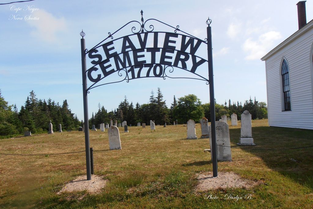
| Description | : | Seaview cemetery is one of the earliest in the area (1635 to 1818) . The French arrived in this area first about 1635. The early graves were marked with field stones. Seaview Cemetery surrounds the church (Gothic Revival architecture) Early missionaries & preachers came about 1784-1785 to convert residents to Methodism. By 1804 a log structure was erected & by 1818 a wood frame structure was erected. It is believed the preachers erected the meeting Hall in this location because of the existence of the graveyard. Seaview cemetery because overcrowded so in 1953... Read More |
frequently asked questions (FAQ):
-
Where is Seaview Cemetery?
Seaview Cemetery is located at 28 Church Road ( off Blanche Road) Cape Negro, Shelburne County ,Nova Scotia , BOW 1KOCanada.
-
Seaview Cemetery cemetery's updated grave count on graveviews.com?
12 memorials
-
Where are the coordinates of the Seaview Cemetery?
Latitude: 43.5540850
Longitude: -65.4438020
Nearby Cemetories:
1. Hillside Cemetery
Cape Negro, Shelburne County, Canada
Coordinate: 43.5563700, -65.4534960
2. Old Kirk Cemetery
North East Point, Shelburne County, Canada
Coordinate: 43.5491240, -65.3982850
3. Pleasant Plain Cemetery
North West Harbour, Shelburne County, Canada
Coordinate: 43.5496673, -65.3979585
4. Harbour View Cemetery
Port Saxon, Shelburne County, Canada
Coordinate: 43.5866700, -65.4284730
5. Parkdale Cemetery
Upper Port La Tour, Shelburne County, Canada
Coordinate: 43.5156570, -65.4655722
6. Port Clyde Cemetery
Port Clyde, Shelburne County, Canada
Coordinate: 43.5944429, -65.4657523
7. Camp Hill Cemetery
Port La Tour, Shelburne County, Canada
Coordinate: 43.5033050, -65.4845240
8. Ingomar Community Cemetery
Ingomar, Shelburne County, Canada
Coordinate: 43.5730968, -65.3581679
9. Ponds Cemetery
Port La Tour, Shelburne County, Canada
Coordinate: 43.4977020, -65.5054660
10. Villagedale Cemetery
Villagedale, Shelburne County, Canada
Coordinate: 43.5379720, -65.5476840
11. Smithsville Union Cemetery
Smithsville, Shelburne County, Canada
Coordinate: 43.4791670, -65.4738890
12. Saint Matthews Cemetery
Clyde River, Shelburne County, Canada
Coordinate: 43.6319900, -65.4779200
13. Roseway Cemetery
Roseway, Shelburne County, Canada
Coordinate: 43.6239909, -65.3501101
14. Barrington River Cemetery
Barrington, Shelburne County, Canada
Coordinate: 43.5667700, -65.5797000
15. River Dale Cemetery
Riverhead, Shelburne County, Canada
Coordinate: 43.5709930, -65.5878290
16. Hillside Cemetery
Barrington, Shelburne County, Canada
Coordinate: 43.5520000, -65.6014667
17. Forest Hill Cemetery
Barrington Passage, Shelburne County, Canada
Coordinate: 43.5275000, -65.6091670
18. Atlantic Cemetery
Stoney Island, Shelburne County, Canada
Coordinate: 43.4681600, -65.5755600
19. Centreville Cemetery
Centreville, Shelburne County, Canada
Coordinate: 43.4842510, -65.6117500
20. United Baptist Church Cemetery
Barrington Passage, Shelburne County, Canada
Coordinate: 43.5192870, -65.6316240
21. Dall Cemetery
Lower Sandy Point, Shelburne County, Canada
Coordinate: 43.6730720, -65.2881470
22. Atwoods Brook Cemetery - Old
Atwoods Brook, Shelburne County, Canada
Coordinate: 43.5036110, -65.6611110
23. Birch Hill Cemetery
Shelburne, Shelburne County, Canada
Coordinate: 43.4990405, -65.6608886
24. Anglican Cemetery
Churchover, Shelburne County, Canada
Coordinate: 43.7142400, -65.3595400