
| Memorials | : | 0 |
| Location | : | James Island, Charleston County, USA |
| Coordinate | : | 32.7268500, -79.9565000 |
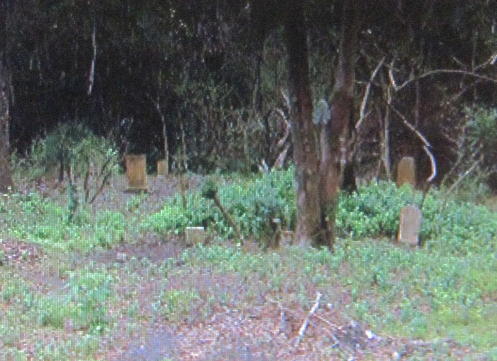
| Description | : | Research shows this used to be referred to as Seabrook Cemetery. This old overgrown cemetery was rediscovered by SCE&G crews clearing an area of Secessionville Road near intersection of Camp Road, James Island,SC. There is no building or church connected with this burying ground. Cemetery is surprisingly large and deep. Much is covered with vines, forest debris, and tree damage from many storms and hurricanes. Based on dates visible, the burials occurred between 1910 and 1959. A cement handmade heart was found in the area. At one time it was placed in the center tree of the cemetery, possibly to... Read More |
frequently asked questions (FAQ):
-
Where is Secessionville Road Cemetery?
Secessionville Road Cemetery is located at James Island, Charleston County ,South Carolina ,USA.
-
Secessionville Road Cemetery cemetery's updated grave count on graveviews.com?
0 memorials
-
Where are the coordinates of the Secessionville Road Cemetery?
Latitude: 32.7268500
Longitude: -79.9565000
Nearby Cemetories:
1. James Island Baptist Church
James Island, Charleston County, USA
Coordinate: 32.7316971, -79.9619293
2. First Baptist Church Cemetery
James Island, Charleston County, USA
Coordinate: 32.7265200, -79.9484000
3. Saint James Presbyterian Church Cemetery
James Island, Charleston County, USA
Coordinate: 32.7195816, -79.9569092
4. Payne RMUE Church Cemetery
Charleston, Charleston County, USA
Coordinate: 32.7337600, -79.9632800
5. James Island Presbyterian Church Cemetery
James Island, Charleston County, USA
Coordinate: 32.7178917, -79.9642029
6. Burn Church Cemetery
James Island, Charleston County, USA
Coordinate: 32.7172500, -79.9653300
7. Bishop Gadsden Columbarium
Charleston, Charleston County, USA
Coordinate: 32.7341340, -79.9758710
8. Saint James Episcopal Church Cemetery
James Island, Charleston County, USA
Coordinate: 32.7350273, -79.9767914
9. James Island Civil War Battlefield
James Island, Charleston County, USA
Coordinate: 32.7045800, -79.9460600
10. Saint James Memorial Gardens
James Island, Charleston County, USA
Coordinate: 32.7049900, -79.9747300
11. Evergreen Cemetery
James Island, Charleston County, USA
Coordinate: 32.7027140, -79.9734650
12. Bethel AME Church Cemetery
James Island, Charleston County, USA
Coordinate: 32.7456100, -79.9813200
13. Payne RMUE Church Memorial Garden
James Island, Charleston County, USA
Coordinate: 32.7035179, -79.9792328
14. Heavenly Rest Cemetery
Charleston, Charleston County, USA
Coordinate: 32.7494500, -79.9868500
15. Mount Sinai Evangelistic Cemetery
James Island, Charleston County, USA
Coordinate: 32.7483960, -79.9883470
16. Holy Cross Cemetery
James Island, Charleston County, USA
Coordinate: 32.7411160, -79.9151860
17. Stem Point Memorial Cemetery
James Island, Charleston County, USA
Coordinate: 32.6872711, -79.9561539
18. McLeod Cemetery
James Island, Charleston County, USA
Coordinate: 32.7645000, -79.9737100
19. Saint Peters Episcopal Church Cemetery
Charleston, Charleston County, USA
Coordinate: 32.7750015, -79.9357986
20. First Baptist Churchyard
Charleston, Charleston County, USA
Coordinate: 32.7737122, -79.9306564
21. First Scots Presbyterian Church Cemetery
Charleston, Charleston County, USA
Coordinate: 32.7742271, -79.9315872
22. Cathedral of Saint John the Baptist
Charleston, Charleston County, USA
Coordinate: 32.7763020, -79.9344420
23. Quaker Churchyard
Charleston, Charleston County, USA
Coordinate: 32.7771988, -79.9328003
24. Saint Michaels Church Cemetery
Charleston, Charleston County, USA
Coordinate: 32.7765388, -79.9302444