
| Memorials | : | 0 |
| Location | : | Clifton, Bosque County, USA |
| Coordinate | : | 31.7442330, -97.5929670 |
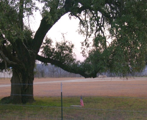
| Description | : | This is a single gravesite on private property owned by Steve and Kathy Harr, near Clifton, TX. A military marker is placed under a huge liveoak tree in front of the remodeled home that once belonged to the Seljos family. The site is located on Bosque County Road 4245, and is easily viewed from the country road. Driving directions: In Clifton, at the junction of Texas 6 and FM 219, go west on FM 219 for 2.3 miles to County Road 4240. Turn left on CR 4240 and go .6 mile to CR 4245 on left. Turn left on CR 4245... Read More |
frequently asked questions (FAQ):
-
Where is Seljos Gravesite?
Seljos Gravesite is located at Clifton, Bosque County ,Texas ,USA.
-
Seljos Gravesite cemetery's updated grave count on graveviews.com?
0 memorials
-
Where are the coordinates of the Seljos Gravesite?
Latitude: 31.7442330
Longitude: -97.5929670
Nearby Cemetories:
1. Clifton Cemetery
Clifton, Bosque County, USA
Coordinate: 31.7728004, -97.5716705
2. Trinity Lutheran Cemetery
Clifton, Bosque County, USA
Coordinate: 31.7733994, -97.5720139
3. Terrell Family Cemetery
Bosque County, USA
Coordinate: 31.7138996, -97.5697021
4. Gary Cemetery
Bosque County, USA
Coordinate: 31.7256170, -97.5502830
5. Long Graves
Bosque County, USA
Coordinate: 31.7173500, -97.5374700
6. Kanz Cemetery
Bosque County, USA
Coordinate: 31.6887270, -97.5518010
7. Norway Mills Cemetery
Bosque County, USA
Coordinate: 31.6977997, -97.6564026
8. Oswald Cemetery
Clifton, Bosque County, USA
Coordinate: 31.8146992, -97.5777969
9. Greene Family Cemetery
Norse, Bosque County, USA
Coordinate: 31.7716520, -97.6777880
10. Our Savior's Lutheran Cemetery
Norse, Bosque County, USA
Coordinate: 31.7722321, -97.6781006
11. Lanes Chapel Memorial Cemetery
Valley Mills, Bosque County, USA
Coordinate: 31.6665660, -97.5914700
12. Clifton Memorial Park
Clifton, Bosque County, USA
Coordinate: 31.8223324, -97.5805817
13. Norse Seventh-Day Adventist Church Cemetery
Clifton, Bosque County, USA
Coordinate: 31.7910330, -97.6710500
14. Centerpoint Cemetery
Valley Mills, Bosque County, USA
Coordinate: 31.7207370, -97.4999840
15. Saint John's Bismarck Cemetery
Bosque County, USA
Coordinate: 31.7385800, -97.4941500
16. Scrutchfield Cemetery
Valley Mills, Bosque County, USA
Coordinate: 31.6655000, -97.5157170
17. Post Oak Cemetery
Hurst Springs, Coryell County, USA
Coordinate: 31.6542500, -97.6690200
18. Knowles Cemetery
Bosque County, USA
Coordinate: 31.6406498, -97.5382538
19. Old Rock Church Cemetery at Hog Creek
Valley Mills, Bosque County, USA
Coordinate: 31.6383667, -97.5379181
20. Barton Cemetery
Mosheim, Bosque County, USA
Coordinate: 31.6322210, -97.5525350
21. Rainey Cemetery
Hurst Springs, Coryell County, USA
Coordinate: 31.6570111, -97.6860333
22. Evans Family Cemetery
Cranfills Gap, Bosque County, USA
Coordinate: 31.7930550, -97.7219580
23. Old Valley Mills Cemetery
Valley Mills, Bosque County, USA
Coordinate: 31.6732998, -97.4728012
24. Womack Cemetery
Bosque County, USA
Coordinate: 31.8386980, -97.4935930