
| Memorials | : | 6 |
| Location | : | Pendleton, Anderson County, USA |
| Coordinate | : | 34.7103050, -82.7065210 |
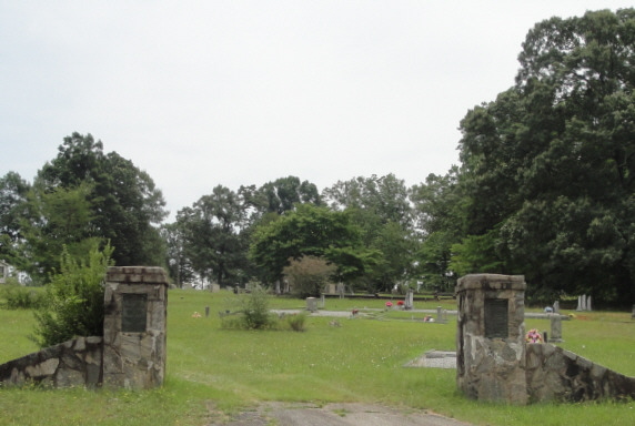
| Description | : | Sharon United Methodist Church was established in 1840. There is a marker placed in the 1960's that has the wrong date of 1873 on it. The correct date is on two bronze plaques found on the stone cemetery gates which were erected in the 1930's as a result of the fund-raising efforts of Mary Olivia (Newton) Evatt. To find church take Highway 88 between Pendleton and Slabtown. Go pass the road to Central (S-39-18) 1.7 miles. Turn left on S-4-163. Go .8 miles to intersection of Burdette Drive and Highway 163. Church is on the left... Read More |
frequently asked questions (FAQ):
-
Where is Sharon United Methodist Church Cemetery?
Sharon United Methodist Church Cemetery is located at Sharon Church Road Pendleton, Anderson County ,South Carolina , 29630USA.
-
Sharon United Methodist Church Cemetery cemetery's updated grave count on graveviews.com?
6 memorials
-
Where are the coordinates of the Sharon United Methodist Church Cemetery?
Latitude: 34.7103050
Longitude: -82.7065210

Nearby Cemetories:
1. Fielding-Martin Family Cemetery
Anderson County, USA
Coordinate: 34.7001780, -82.6886660
2. White Oak Springs Baptist Church Cemetery
Central, Pickens County, USA
Coordinate: 34.7179330, -82.7344000
3. Calvary Baptist Church Cemetery
Pendleton, Anderson County, USA
Coordinate: 34.7032930, -82.6753490
4. Johnston Family Cemetery
Liberty, Pickens County, USA
Coordinate: 34.7374001, -82.7284012
5. Maverick Family Cemetery
Anderson County, USA
Coordinate: 34.6949005, -82.7414017
6. Corinth #2 Baptist Church Cemetery
Anderson County, USA
Coordinate: 34.6773610, -82.7133890
7. Boggs-Garner Family Cemetery
Liberty, Pickens County, USA
Coordinate: 34.7489800, -82.7005080
8. Silas Clayton Family Cemetery
Liberty, Pickens County, USA
Coordinate: 34.7487170, -82.7192670
9. Refuge Baptist Church Cemetery
Anderson County, USA
Coordinate: 34.6886230, -82.7506360
10. Bethany Methodist Episcopal Church Cemetery
Anderson County, USA
Coordinate: 34.6819110, -82.6668570
11. Ruhamah Baptist Church Cemetery
Liberty, Pickens County, USA
Coordinate: 34.7578011, -82.7043991
12. Rankin Family Cemetery
Anderson County, USA
Coordinate: 34.7108670, -82.6437330
13. Flat Rock Baptist Church Cemetery
Liberty, Pickens County, USA
Coordinate: 34.7498398, -82.6614685
14. Boggs Family Cemetery
Liberty, Pickens County, USA
Coordinate: 34.7495830, -82.6602500
15. New Olive Grove Baptist Church Cemetery
Central, Pickens County, USA
Coordinate: 34.7327100, -82.7673160
16. Golden Grove Wesleyan Church Cemetery
Liberty, Pickens County, USA
Coordinate: 34.7557983, -82.6605988
17. Hallum Family Cemetery
Liberty, Pickens County, USA
Coordinate: 34.7653999, -82.6778030
18. Hendricks-Prater Cemetery
Liberty, Pickens County, USA
Coordinate: 34.7725500, -82.7239500
19. Williams Family Cemetery
Liberty, Pickens County, USA
Coordinate: 34.7737000, -82.6883500
20. Simpson Cemetery
Pendleton, Anderson County, USA
Coordinate: 34.6467018, -82.7247009
21. Ballentine Cemetery
Pickens County, USA
Coordinate: 34.7415009, -82.7768021
22. Mount Zion Cemetery
Central, Pickens County, USA
Coordinate: 34.7188988, -82.7874985
23. Mullikin Family Cemetery
Anderson, Anderson County, USA
Coordinate: 34.6838950, -82.6302500
24. Carmel Presbyterian Church Cemetery
Liberty, Pickens County, USA
Coordinate: 34.7557983, -82.6417007