
| Memorials | : | 242 |
| Location | : | Liberty, Pickens County, USA |
| Coordinate | : | 34.7557983, -82.6417007 |
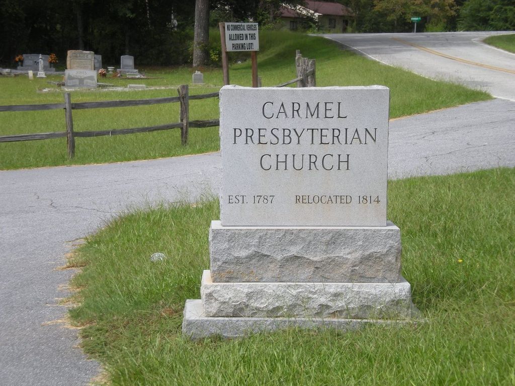
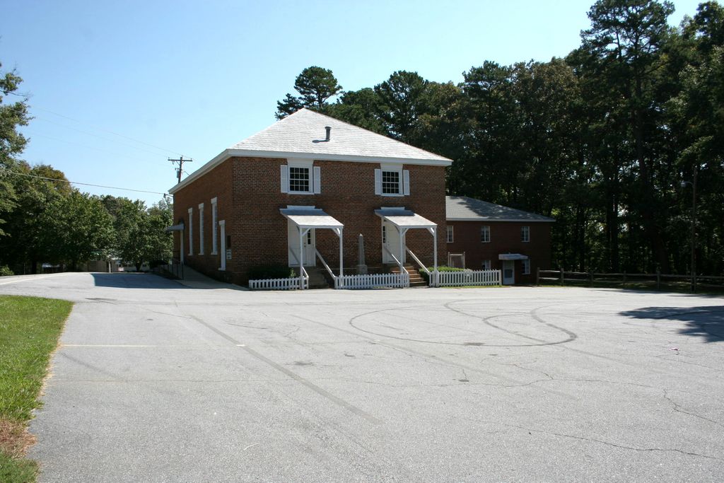
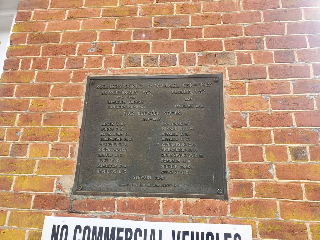
| Description | : | CARMEL PRESBYTERIAN CHURCH CEMETERY (1820), Pickens County, SC One of the earliest churches to be formed in Pickens County, SC was Carmel. After the Treaty of Hopewell was signed the up-country of South Carolina was opened for settlement, and the Scots-Irish Presbyterians from Pennsylvania and Virginia arrived. Carmel was moved to the current location about 1814. The church still exists and is located at SC 135 and Carmel Church Road not far from the Pickens-Anderson County line. |
frequently asked questions (FAQ):
-
Where is Carmel Presbyterian Church Cemetery?
Carmel Presbyterian Church Cemetery is located at 517 Flat Rock Road Liberty, Pickens County ,South Carolina , 29657USA.
-
Carmel Presbyterian Church Cemetery cemetery's updated grave count on graveviews.com?
1 memorials
-
Where are the coordinates of the Carmel Presbyterian Church Cemetery?
Latitude: 34.7557983
Longitude: -82.6417007


Nearby Cemetories:
1. Golden Grove Wesleyan Church Cemetery
Liberty, Pickens County, USA
Coordinate: 34.7557983, -82.6605988
2. Boggs Family Cemetery
Liberty, Pickens County, USA
Coordinate: 34.7495830, -82.6602500
3. Flat Rock Baptist Church Cemetery
Liberty, Pickens County, USA
Coordinate: 34.7498398, -82.6614685
4. Grace Baptist Church Cemetery
Liberty, Pickens County, USA
Coordinate: 34.7846760, -82.6394180
5. Hallum Family Cemetery
Liberty, Pickens County, USA
Coordinate: 34.7653999, -82.6778030
6. Mount Calvary Wesleyan Church Cemetery
Easley, Pickens County, USA
Coordinate: 34.7829000, -82.6223670
7. Zion United Methodist Church Cemetery Old
Easley, Pickens County, USA
Coordinate: 34.7793000, -82.6066170
8. Corinth Baptist Church #1 Cemetery
Anderson County, USA
Coordinate: 34.7624160, -82.5922170
9. Smith Grove Baptist Church Cemetery
Easley, Pickens County, USA
Coordinate: 34.7969017, -82.6466980
10. Williams Family Cemetery
Liberty, Pickens County, USA
Coordinate: 34.7737000, -82.6883500
11. Fellowship Independent Church Cemetery
Anderson County, USA
Coordinate: 34.7191400, -82.6138100
12. Fellowship Church Cemetery
Liberty, Pickens County, USA
Coordinate: 34.7190140, -82.6136830
13. Zion Methodist Church Cemetery
Easley, Pickens County, USA
Coordinate: 34.7822000, -82.5981670
14. Pickens Cemetery
Anderson County, USA
Coordinate: 34.7392006, -82.5911026
15. Rankin Family Cemetery
Anderson County, USA
Coordinate: 34.7108670, -82.6437330
16. Boggs-Garner Family Cemetery
Liberty, Pickens County, USA
Coordinate: 34.7489800, -82.7005080
17. Fairview United Methodist Church Cemetery
Anderson County, USA
Coordinate: 34.7714005, -82.5824966
18. Ruhamah Baptist Church Cemetery
Liberty, Pickens County, USA
Coordinate: 34.7578011, -82.7043991
19. Slabtown Memorial Cemetery
Anderson, Anderson County, USA
Coordinate: 34.7093000, -82.6125500
20. New Mount Pisgah Baptist Church
Anderson County, USA
Coordinate: 34.7180720, -82.5866800
21. Liberty Memorial Gardens
Liberty, Pickens County, USA
Coordinate: 34.7839280, -82.7050780
22. Abbott Cemetery
Liberty, Pickens County, USA
Coordinate: 34.7815000, -82.7067670
23. Calvary Baptist Church Cemetery
Pendleton, Anderson County, USA
Coordinate: 34.7032930, -82.6753490
24. West View Cemetery
Liberty, Pickens County, USA
Coordinate: 34.7822890, -82.7064940