
| Memorials | : | 0 |
| Location | : | Shunesburg, Washington County, USA |
| Coordinate | : | 37.1580000, -112.9780000 |
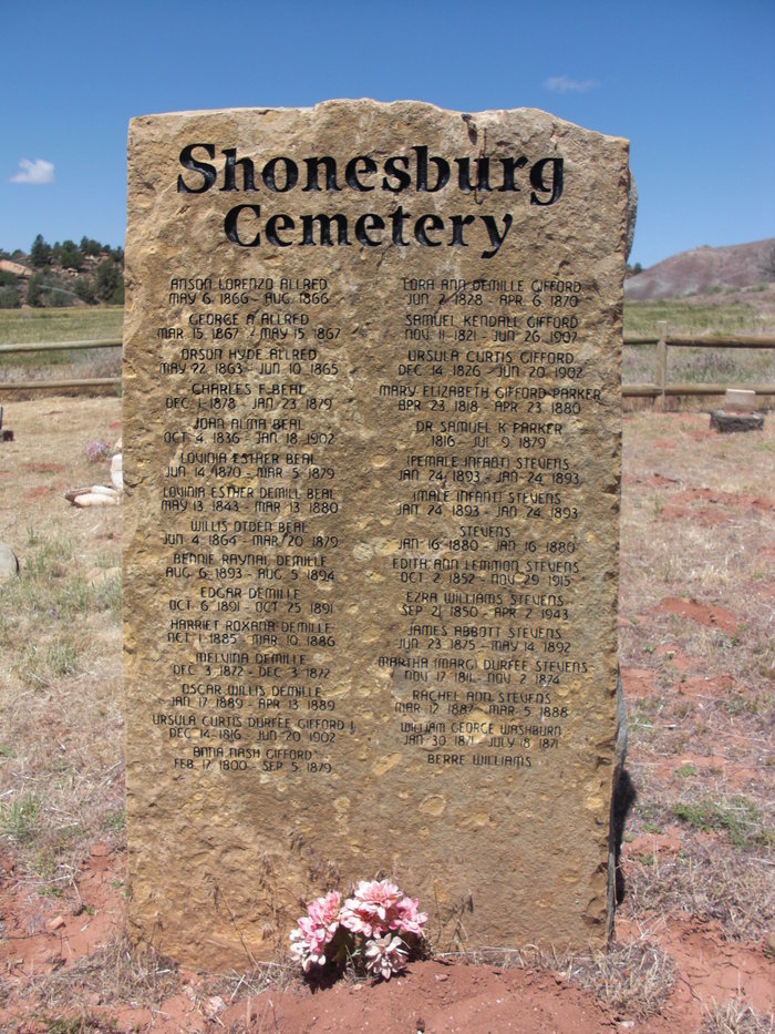
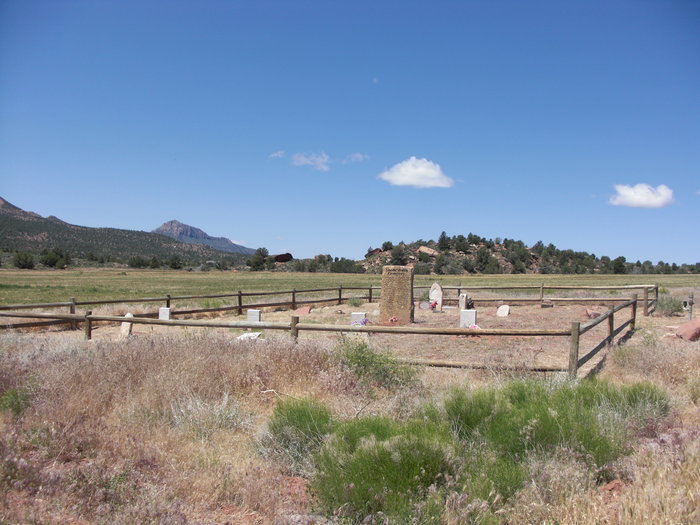
| Description | : | The cemetery is located in the ghost town of Shunesburg (also pronounced Shonesburg) and is off of Utah hwy 9 between Rockville and Sprindale on the east fork of the Virgin River. It is located on privately owned farmland approximately 2.2 miles east of Utah hwy 9. |
frequently asked questions (FAQ):
-
Where is Shunesburg Cemetery?
Shunesburg Cemetery is located at Shunesburg, Washington County ,Utah ,USA.
-
Shunesburg Cemetery cemetery's updated grave count on graveviews.com?
0 memorials
-
Where are the coordinates of the Shunesburg Cemetery?
Latitude: 37.1580000
Longitude: -112.9780000
Nearby Cemetories:
1. Hilltop Cemetery
Springdale, Washington County, USA
Coordinate: 37.1911000, -112.9986000
2. Jolley-Gifford Cemetery
Springdale, Washington County, USA
Coordinate: 37.1932983, -113.0010986
3. Rockville Cemetery
Rockville, Washington County, USA
Coordinate: 37.1618996, -113.0333023
4. Grafton Cemetery
Grafton, Washington County, USA
Coordinate: 37.1631012, -113.0800018
5. Duncans Retreat Cemetery
Virgin, Washington County, USA
Coordinate: 37.1839100, -113.1351000
6. Baby Cemetery
Hildale, Washington County, USA
Coordinate: 37.0089750, -112.9678300
7. Hammon Cemetery
Colorado City, Mohave County, USA
Coordinate: 36.9969370, -112.9789660
8. Isaac W. Carling Memorial Park
Colorado City, Mohave County, USA
Coordinate: 36.9903984, -112.9651031
9. Virgin Cemetery
Virgin, Washington County, USA
Coordinate: 37.2063970, -113.1912750
10. Centennial Park Cemetery
Centennial Park, Mohave County, USA
Coordinate: 36.9573600, -112.9863000
11. Cox Family Cemetery
Cane Beds, Mohave County, USA
Coordinate: 36.9525000, -112.8923000
12. Finicum Family Cemetery
Cane Beds, Mohave County, USA
Coordinate: 36.9308540, -112.8908710
13. La Verkin Cemetery
La Verkin, Washington County, USA
Coordinate: 37.2131004, -113.2699966
14. Hurricane City Cemetery
Hurricane, Washington County, USA
Coordinate: 37.1856003, -113.2842026
15. Toquerville Cemetery
Toquerville, Washington County, USA
Coordinate: 37.2282982, -113.2814026
16. Kolob Mountain Cemetery
Washington County, USA
Coordinate: 37.4075000, -113.0351600
17. Mount Carmel Cemetery
Mount Carmel, Kane County, USA
Coordinate: 37.2475014, -112.6678009
18. Grant Thompson Memorial
Hurricane, Washington County, USA
Coordinate: 37.0361003, -113.3008758
19. Anderson Family Cemetery
Toquerville, Washington County, USA
Coordinate: 37.2815000, -113.3020000
20. Orderville Cemetery
Orderville, Kane County, USA
Coordinate: 37.2722015, -112.6367035
21. Pintura Cemetery
Pintura, Washington County, USA
Coordinate: 37.3433910, -113.2745360
22. Moccasin Cemetery
Moccasin, Mohave County, USA
Coordinate: 36.9103370, -112.7567840
23. Silver Reef Protestant Cemetery
Leeds, Washington County, USA
Coordinate: 37.2455292, -113.3622589
24. Silver Reef Catholic Cemetery
Leeds, Washington County, USA
Coordinate: 37.2448807, -113.3650436