
| Memorials | : | 0 |
| Location | : | Voeren, Arrondissement Tongeren, Belgium |
| Coordinate | : | 50.7492100, 5.8127200 |
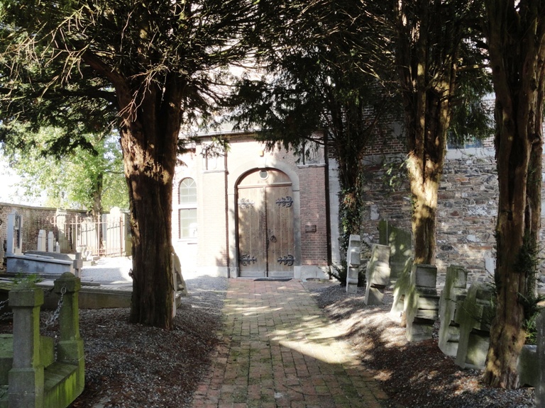
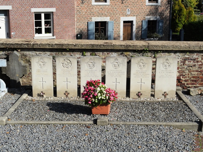
| Description | : | The village of Sint-Martens-Voeren is located north of the town of Verviers off the motorway E25. From the motorway E25 which runs between Maastricht and Cheratte turn off at junction 1 and at the T junction turn right towards Moelingen. Follow this road through the village and through the next village 'S-Gravenvoeren and on into Sint-Martens-Voeren. On entering the village the church is on the left and the churchyard is behind the church. The graves are located by the right hand wall. |
frequently asked questions (FAQ):
-
Where is Sint-Martens-Voeren Churchyard?
Sint-Martens-Voeren Churchyard is located at Voeren, Arrondissement Tongeren ,Limburg ,Belgium.
-
Sint-Martens-Voeren Churchyard cemetery's updated grave count on graveviews.com?
0 memorials
-
Where are the coordinates of the Sint-Martens-Voeren Churchyard?
Latitude: 50.7492100
Longitude: 5.8127200
Nearby Cemetories:
1. Begraafplaats Banholt
Banholt, Eijsden-Margraten Municipality, Netherlands
Coordinate: 50.7911800, 5.8139700
2. Remersdaal Cemetery
Voeren, Arrondissement Tongeren, Belgium
Coordinate: 50.7306241, 5.8790311
3. Reijmerstok Begraafplaats
Reijmerstok, Gulpen-Wittem Municipality, Netherlands
Coordinate: 50.7994500, 5.8407600
4. Cimetière d'Aubel
Aubel, Arrondissement de Verviers, Belgium
Coordinate: 50.6975172, 5.8515058
5. Netherlands American Cemetery and Memorial
Margraten, Eijsden-Margraten Municipality, Netherlands
Coordinate: 50.8176918, 5.8046441
6. Zusterbegraafplaats Rijckholt
Rijckholt, Eijsden-Margraten Municipality, Netherlands
Coordinate: 50.7961186, 5.7328002
7. Joodse Begraafplaats
Eijsden-Margraten Municipality, Netherlands
Coordinate: 50.7760600, 5.7065700
8. Vise Communal Cemetery
Visé, Arrondissement de Liège, Belgium
Coordinate: 50.7311700, 5.7014200
9. Hombourg Churchyard
Plombières, Arrondissement de Verviers, Belgium
Coordinate: 50.7233828, 5.9202556
10. Henri-Chapelle American Cemetery and Memorial
Henri-Chapelle, Arrondissement de Verviers, Belgium
Coordinate: 50.6965942, 5.8988428
11. Joodse Begraafplaats
Gulpen, Gulpen-Wittem Municipality, Netherlands
Coordinate: 50.8135290, 5.8865910
12. Charneux Churchyard
Herve, Arrondissement de Verviers, Belgium
Coordinate: 50.6690100, 5.8051100
13. Lanaye Communal Cemetery
Visé, Arrondissement de Liège, Belgium
Coordinate: 50.7819100, 5.6966500
14. Cadier en Keer Kerkhof
Cadier en Keer, Eijsden-Margraten Municipality, Netherlands
Coordinate: 50.8268600, 5.7695500
15. Lixhe Communal Cemetery
Visé, Arrondissement de Liège, Belgium
Coordinate: 50.7548600, 5.6786400
16. Mechelen Kerkhof Cemetery
Mechelen, Gulpen-Wittem Municipality, Netherlands
Coordinate: 50.7964000, 5.9256700
17. Mechelen Kerk Begraafplaats apex
Mechelen, Gulpen-Wittem Municipality, Netherlands
Coordinate: 50.7981500, 5.9282700
18. Saint-Remy Churchyard
Blegny, Arrondissement de Liège, Belgium
Coordinate: 50.6960700, 5.7010800
19. Wijlre Kerkhof
Wijlre, Gulpen-Wittem Municipality, Netherlands
Coordinate: 50.8315400, 5.8945100
20. Thimister Cemetery
Thimister-Clermont, Arrondissement de Verviers, Belgium
Coordinate: 50.6571900, 5.8664200
21. Montzen Cemetery
Plombières, Arrondissement de Verviers, Belgium
Coordinate: 50.7111442, 5.9636557
22. Kanne Cemetery
Riemst, Arrondissement Tongeren, Belgium
Coordinate: 50.8143100, 5.6774900
23. Begraafplaats Katholieke Kerk Heugem
Maastricht, Maastricht Municipality, Netherlands
Coordinate: 50.8315572, 5.7026935
24. R.K. Begraafplaats
Eys, Gulpen-Wittem Municipality, Netherlands
Coordinate: 50.8260056, 5.9327850