
| Memorials | : | 0 |
| Location | : | Skelmanthorpe, Metropolitan Borough of Kirklees, England |
| Coordinate | : | 53.5928110, -1.6460640 |
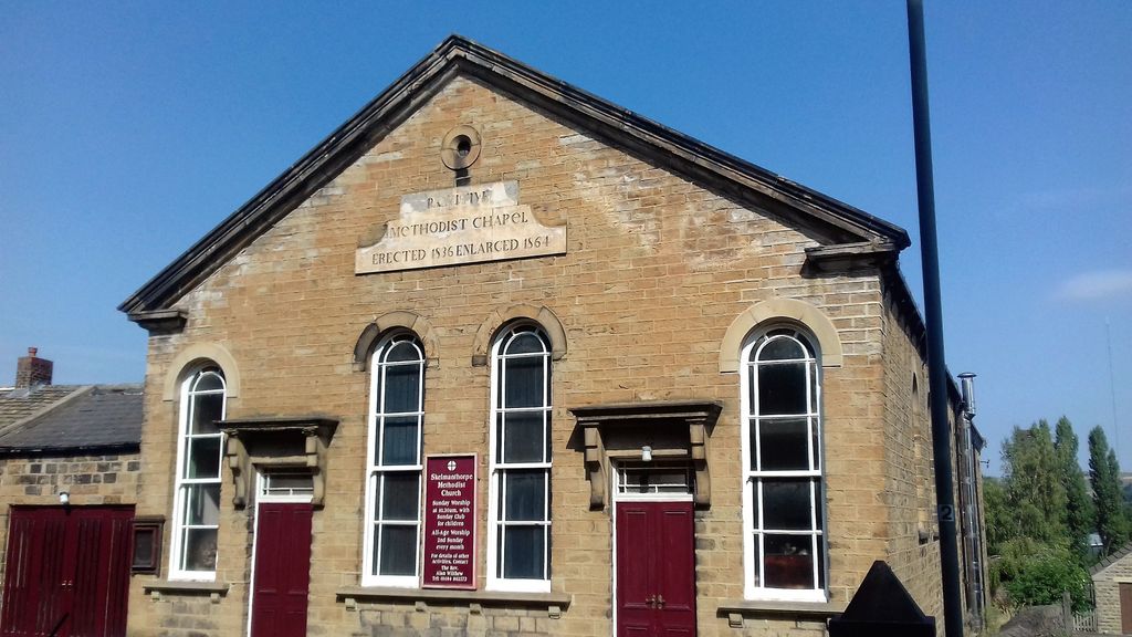
| Description | : | Also known as: Providential Chapel (1854 map), Pilling Lane Methodist Church (1960 map), Skelmanthorpe Methodist Church (current name) location: Pilling Lane, Skelmanthorpe status: still exists category: church or chapel |
frequently asked questions (FAQ):
-
Where is Skelmanthorpe Primitive Methodist Church Cemetery?
Skelmanthorpe Primitive Methodist Church Cemetery is located at Pilling Lane, Huddersfield. Skelmanthorpe, Metropolitan Borough of Kirklees ,West Yorkshire , HD8 9EQEngland.
-
Skelmanthorpe Primitive Methodist Church Cemetery cemetery's updated grave count on graveviews.com?
0 memorials
-
Where are the coordinates of the Skelmanthorpe Primitive Methodist Church Cemetery?
Latitude: 53.5928110
Longitude: -1.6460640
Nearby Cemetories:
1. Skelmanthorpe Cemetery
Skelmanthorpe, Metropolitan Borough of Kirklees, England
Coordinate: 53.5884340, -1.6385120
2. St Augustine Churchyard
Scissett, Metropolitan Borough of Kirklees, England
Coordinate: 53.5896520, -1.6254190
3. Emmanuel Churchyard
Shelley, Metropolitan Borough of Kirklees, England
Coordinate: 53.5976700, -1.6812200
4. All Saint's (Clayton West with High Hoyland)
Clayton West, Metropolitan Borough of Kirklees, England
Coordinate: 53.5946154, -1.6097522
5. St Michael the Archangel Churchyard
Emley, Metropolitan Borough of Kirklees, England
Coordinate: 53.6159010, -1.6316560
6. St. Nicholas' Churchyard
Upper Cumberworth, Metropolitan Borough of Kirklees, England
Coordinate: 53.5755000, -1.6827450
7. Shelley Bank Methodist Chapelyard
Shelley, Metropolitan Borough of Kirklees, England
Coordinate: 53.5945800, -1.6967000
8. St. John the Evangelist Churchyard
Denby Dale, Metropolitan Borough of Kirklees, England
Coordinate: 53.5608580, -1.6595360
9. All Hallows Churchyard
High Hoyland, Metropolitan Borough of Barnsley, England
Coordinate: 53.5915000, -1.5868500
10. Quaker Bottom Burial Ground
Huddersfield, Metropolitan Borough of Kirklees, England
Coordinate: 53.5633390, -1.6809182
11. Friends Meeting House
Penistone, Metropolitan Borough of Barnsley, England
Coordinate: 53.5627869, -1.6817849
12. All Hallows Churchyard
Kirkburton, Metropolitan Borough of Kirklees, England
Coordinate: 53.6086040, -1.7021970
13. Zion Congregational Chapelyard
Flockton, Metropolitan Borough of Kirklees, England
Coordinate: 53.6302300, -1.6502900
14. St. James the Great Churchyard
Flockton, Metropolitan Borough of Kirklees, England
Coordinate: 53.6305700, -1.6386230
15. Shepley Methodist Chapelyard
Shepley, Metropolitan Borough of Kirklees, England
Coordinate: 53.5844400, -1.7105900
16. St Paul Churchyard
Shepley, Metropolitan Borough of Kirklees, England
Coordinate: 53.5836620, -1.7120400
17. St Bartholomew Churchyard
Grange Moor, Metropolitan Borough of Kirklees, England
Coordinate: 53.6392000, -1.6685200
18. St John the Evangelist Churchyard
Lepton, Metropolitan Borough of Kirklees, England
Coordinate: 53.6317900, -1.6996800
19. St Johns Church Lepton
Kirkheaton, Metropolitan Borough of Kirklees, England
Coordinate: 53.6320600, -1.6993700
20. Cawthorne Cemetery
Barnsley, Metropolitan Borough of Barnsley, England
Coordinate: 53.5673699, -1.5713055
21. St Bartholomew Chapelyard
West Bretton, Metropolitan Borough of Wakefield, England
Coordinate: 53.6117750, -1.5638600
22. Dogley Lane Congregational Churchyard
Kirkburton, Metropolitan Borough of Kirklees, England
Coordinate: 53.6233052, -1.7182092
23. Hoylandswaine Churchyard
Sheffield, Metropolitan Borough of Sheffield, England
Coordinate: 53.5431500, -1.6087800
24. Netherton Cemetery
Netherton, Metropolitan Borough of Wakefield, England
Coordinate: 53.6398300, -1.5852510