| Memorials | : | 0 |
| Location | : | Kirkburton, Metropolitan Borough of Kirklees, England |
| Coordinate | : | 53.6233052, -1.7182092 |
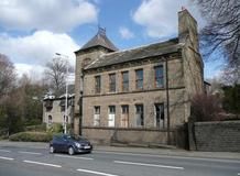
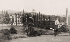
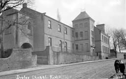
| Description | : | Also known as: Independant Chapel, Penistone Road, Dogley Lane, Kirkburton Partially exists but now under a different use The one time premises of Dogley Lane Congregational Church are now divided into a dwelling house and a workshop. Opened in 1816 the church survived until the 1960s when a dwindling congregation inevitably led to its closure. The surviving portion of the building is the former Sunday School , the cornerstones of which were laid on 5 August 1882. A residential property now occupies the site of the chapel. |
frequently asked questions (FAQ):
-
Where is Dogley Lane Congregational Churchyard?
Dogley Lane Congregational Churchyard is located at Penistone Road Kirkburton, Metropolitan Borough of Kirklees ,West Yorkshire ,England.
-
Dogley Lane Congregational Churchyard cemetery's updated grave count on graveviews.com?
0 memorials
-
Where are the coordinates of the Dogley Lane Congregational Churchyard?
Latitude: 53.6233052
Longitude: -1.7182092
Nearby Cemetories:
1. St John the Evangelist Churchyard
Lepton, Metropolitan Borough of Kirklees, England
Coordinate: 53.6317900, -1.6996800
2. St Johns Church Lepton
Kirkheaton, Metropolitan Borough of Kirklees, England
Coordinate: 53.6320600, -1.6993700
3. All Hallows Churchyard
Kirkburton, Metropolitan Borough of Kirklees, England
Coordinate: 53.6086040, -1.7021970
4. All Hallows Churchyard
Almondbury, Metropolitan Borough of Kirklees, England
Coordinate: 53.6316620, -1.7467620
5. Almondbury Cemetery
Almondbury, Metropolitan Borough of Kirklees, England
Coordinate: 53.6341320, -1.7522980
6. St Lucius Churchyard
Farnley Tyas, Metropolitan Borough of Kirklees, England
Coordinate: 53.6107400, -1.7532300
7. St John the Baptist Churchyard
Kirkheaton, Metropolitan Borough of Kirklees, England
Coordinate: 53.6508510, -1.7309650
8. Kirkheaton Cemetery
Kirkheaton, Metropolitan Borough of Kirklees, England
Coordinate: 53.6523100, -1.7228500
9. Shelley Bank Methodist Chapelyard
Shelley, Metropolitan Borough of Kirklees, England
Coordinate: 53.5945800, -1.6967000
10. New Congregational Church
Moldgreen, Metropolitan Borough of Kirklees, England
Coordinate: 53.6433201, -1.7629206
11. St Bartholomew Churchyard
Grange Moor, Metropolitan Borough of Kirklees, England
Coordinate: 53.6392000, -1.6685200
12. Emmanuel Churchyard
Shelley, Metropolitan Borough of Kirklees, England
Coordinate: 53.5976700, -1.6812200
13. St. Thomas Churchyard
Thurstonland, Metropolitan Borough of Kirklees, England
Coordinate: 53.5932710, -1.7501120
14. Christ Church Memorial Garden
Moldgreen, Metropolitan Borough of Kirklees, England
Coordinate: 53.6457200, -1.7651400
15. Hey Lane Cemetery
Huddersfield, Metropolitan Borough of Kirklees, England
Coordinate: 53.6156100, -1.7786000
16. St John the Evangelist Churchyard
Newsome, Metropolitan Borough of Kirklees, England
Coordinate: 53.6280000, -1.7834300
17. Shepley Methodist Chapelyard
Shepley, Metropolitan Borough of Kirklees, England
Coordinate: 53.5844400, -1.7105900
18. St Paul Churchyard
Shepley, Metropolitan Borough of Kirklees, England
Coordinate: 53.5836620, -1.7120400
19. St John the Evangelist Churchyard
Mirfield, Metropolitan Borough of Kirklees, England
Coordinate: 53.6627400, -1.7034200
20. Zion Congregational Chapelyard
Flockton, Metropolitan Borough of Kirklees, England
Coordinate: 53.6302300, -1.6502900
21. St Paul Churchyard
Huddersfield, Metropolitan Borough of Kirklees, England
Coordinate: 53.6438800, -1.7795800
22. St. George's Churchyard
Brockholes, Metropolitan Borough of Kirklees, England
Coordinate: 53.5955900, -1.7724400
23. St. Peter's Churchyard
Huddersfield, Metropolitan Borough of Kirklees, England
Coordinate: 53.6475760, -1.7809710
24. New Conexion Chapel
Huddersfield, Metropolitan Borough of Kirklees, England
Coordinate: 53.6447670, -1.7843060


