
| Memorials | : | 0 |
| Location | : | Round Mountain, Blanco County, USA |
| Coordinate | : | 30.4964620, -98.4416200 |
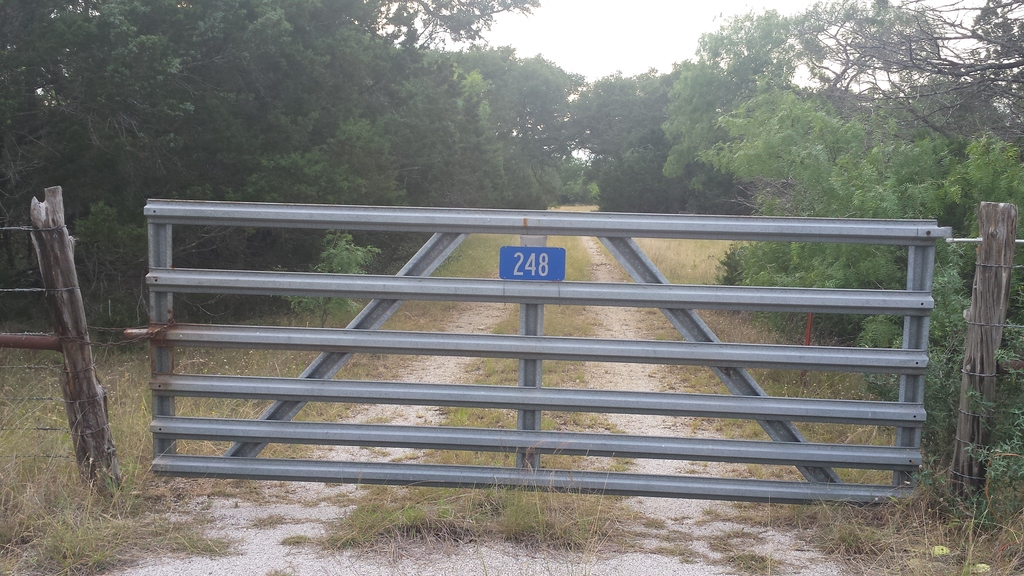
| Description | : | from Round Mountain, take State Road 962 to intersection with Ranch Road 3347. Turn south or left on 3347 and go .1 miles. At the second gate (ranch-style aluminum) on the right, you'll see a sign reading "248" in white letters against a blue background. Open (and close behind you) the gate to reach cemetery which is .1 miles past the gate. Cemetery on private land. Gate may be locked. Cemetery not visible from road. |
frequently asked questions (FAQ):
-
Where is Smith Family Cemetery?
Smith Family Cemetery is located at Round Mountain, Blanco County ,Texas ,USA.
-
Smith Family Cemetery cemetery's updated grave count on graveviews.com?
0 memorials
-
Where are the coordinates of the Smith Family Cemetery?
Latitude: 30.4964620
Longitude: -98.4416200
Nearby Cemetories:
1. Walnut Methodist Church Cemetery
Blanco, Blanco County, USA
Coordinate: 30.4902080, -98.4555270
2. Horseshoe Bay Mausoleum
Marble Falls, Burnet County, USA
Coordinate: 30.5306500, -98.3520500
3. Roberts-Shelley-Hardin Cemetery
Round Mountain, Blanco County, USA
Coordinate: 30.4800420, -98.5501100
4. Round Mountain Cemetery
Round Mountain, Blanco County, USA
Coordinate: 30.4381008, -98.3506012
5. Comanche Cemetery
Blanco County, USA
Coordinate: 30.4927998, -98.5682983
6. Davis Cemetery
Blanco County, USA
Coordinate: 30.4724998, -98.5674973
7. Fuchs Cemetery
Cottonwood Shores, Burnet County, USA
Coordinate: 30.5606900, -98.3262420
8. Wolf Crossing Cemetery
Highland Haven, Burnet County, USA
Coordinate: 30.6194000, -98.3936005
9. Marble Falls City Cemetery
Marble Falls, Burnet County, USA
Coordinate: 30.5716286, -98.2927475
10. Sandy Cemetery
Sandy, Blanco County, USA
Coordinate: 30.3444004, -98.4705963
11. Dead Man's Hole
Marble Falls, Burnet County, USA
Coordinate: 30.5284000, -98.2649000
12. Tobey Cemetery
Marble Falls, Burnet County, USA
Coordinate: 30.6436005, -98.3255997
13. Richter Cemetery
Marble Falls, Burnet County, USA
Coordinate: 30.5471992, -98.2397003
14. Pleasant Valley Cemetery
Marble Falls, Burnet County, USA
Coordinate: 30.5699997, -98.2422028
15. Burnam-Smithart Cemetery
Marble Falls, Burnet County, USA
Coordinate: 30.5182991, -98.2260971
16. Goeth-Wenmohs Family Cemetery
Blanco County, USA
Coordinate: 30.3996890, -98.2502230
17. Konvicka Cemetery
Burnet County, USA
Coordinate: 30.6180992, -98.2694016
18. Joy Cemetery
Burnet County, USA
Coordinate: 30.6436996, -98.2956009
19. Fairland Cemetery
Marble Falls, Burnet County, USA
Coordinate: 30.6419700, -98.2840100
20. Cypress Mill Cemetery
Cypress Mill, Blanco County, USA
Coordinate: 30.3774200, -98.2477300
21. Lakeland Hills Memorial Park
Burnet, Burnet County, USA
Coordinate: 30.6784450, -98.3188500
22. Rockvale Cemetery
Spicewood, Burnet County, USA
Coordinate: 30.5016994, -98.1968994
23. Hoovers Valley Cemetery
Burnet County, USA
Coordinate: 30.7035999, -98.3818970
24. Pangle Cemetery
Burnet County, USA
Coordinate: 30.5781002, -98.2118988