
| Memorials | : | 0 |
| Location | : | Sowerby Bridge, Metropolitan Borough of Calderdale, England |
| Coordinate | : | 53.7059486, -1.9426959 |
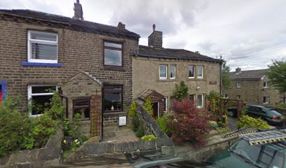
| Description | : | Sowerby Congregational Church opened in June 1862. In the summer of 1889 the chapel was renovated throughout, and at the annual finance meeting in 1896 it was decided to erect a new kitchen and two vestries, these additions were delayed until 1899, the Sunday school now had seven vestries plus the kitchen. Meanwhile the dilapidated condition of the farm at Red Brink was cause for concern so it was decided to pull it down and rebuild on the same site, this meant an outlay of over £300. Two memorial stones were incorporated in re build, one had the inscription Endowed... Read More |
frequently asked questions (FAQ):
-
Where is Sowerby Congregational Church Graveyard?
Sowerby Congregational Church Graveyard is located at 2 Well Head Lane, Sowerby, West Yorkshire Sowerby Bridge, Metropolitan Borough of Calderdale ,West Yorkshire ,England.
-
Sowerby Congregational Church Graveyard cemetery's updated grave count on graveviews.com?
0 memorials
-
Where are the coordinates of the Sowerby Congregational Church Graveyard?
Latitude: 53.7059486
Longitude: -1.9426959
Nearby Cemetories:
1. St. Peter's Churchyard
Sowerby Bridge, Metropolitan Borough of Calderdale, England
Coordinate: 53.7052590, -1.9369570
2. Steep Lane Baptist Chapel Cemetery
Sowerby Bridge, Metropolitan Borough of Calderdale, England
Coordinate: 53.7092690, -1.9573450
3. Luddenden Foot Congregational Churchyard
Luddenden, Metropolitan Borough of Calderdale, England
Coordinate: 53.7166300, -1.9408500
4. Sowerby Bridge Cemetery
Sowerby Bridge, Metropolitan Borough of Calderdale, England
Coordinate: 53.7090600, -1.9219900
5. St George Churchyard
Sowerby Bridge, Metropolitan Borough of Calderdale, England
Coordinate: 53.7048800, -1.9184400
6. Luddenden Foot United Methodist Free Chapel
Luddenden, Metropolitan Borough of Calderdale, England
Coordinate: 53.7213642, -1.9436207
7. Butts Green Baptist Chapelyard
Warley, Metropolitan Borough of Calderdale, England
Coordinate: 53.7214360, -1.9340810
8. Mount Zion Primitive Methodist Chapel Graveyard
Norland, Metropolitan Borough of Calderdale, England
Coordinate: 53.6942630, -1.9215300
9. St. Mary's Churchyard
Sowerby Bridge, Metropolitan Borough of Calderdale, England
Coordinate: 53.6912230, -1.9580330
10. Mill Bank Wesleyan Methodist Graveyard
Sowerby Bridge, Metropolitan Borough of Calderdale, England
Coordinate: 53.6887540, -1.9476840
11. Warley Congregational Cemetery
Warley, Metropolitan Borough of Calderdale, England
Coordinate: 53.7187620, -1.9194400
12. Warley Cemetery
Warley, Metropolitan Borough of Calderdale, England
Coordinate: 53.7194710, -1.9184500
13. Christ Church
Sowerby Bridge, Metropolitan Borough of Calderdale, England
Coordinate: 53.7098310, -1.9072220
14. Bolton Brow Wesleyan Methodist Cemetery
Sowerby Bridge, Metropolitan Borough of Calderdale, England
Coordinate: 53.7103555, -1.9021905
15. St. Luke Norland Churchyard
Norland, Metropolitan Borough of Calderdale, England
Coordinate: 53.7001000, -1.9008200
16. Ebenezer Methodist Chapelyard
Soyland Town, Metropolitan Borough of Calderdale, England
Coordinate: 53.6804790, -1.9446120
17. St Mary Churchyard
Luddenden, Metropolitan Borough of Calderdale, England
Coordinate: 53.7322500, -1.9387700
18. Luddenden Cemetery
Luddenden, Metropolitan Borough of Calderdale, England
Coordinate: 53.7329100, -1.9389600
19. Free United Methodist Chapel
Norland, Metropolitan Borough of Calderdale, England
Coordinate: 53.7029847, -1.8946746
20. St. Bartholomew's Churchyard
Ripponden, Metropolitan Borough of Calderdale, England
Coordinate: 53.6744620, -1.9395150
21. Mytholmroyd Methodist Chapelyard
Mytholmroyd, Metropolitan Borough of Calderdale, England
Coordinate: 53.7277100, -1.9834200
22. St. Michael's Churchyard
Mytholmroyd, Metropolitan Borough of Calderdale, England
Coordinate: 53.7300780, -1.9814340
23. Christ Churchyard
Barkisland, Metropolitan Borough of Calderdale, England
Coordinate: 53.6753350, -1.9196910
24. St. John the Baptist in the Wilderness Churchyard
Cragg Vale, Metropolitan Borough of Calderdale, England
Coordinate: 53.7052900, -2.0007900