
| Memorials | : | 0 |
| Location | : | Cragg Vale, Metropolitan Borough of Calderdale, England |
| Website | : | www.achurchnearyou.com/church/18013/ |
| Coordinate | : | 53.7052900, -2.0007900 |
frequently asked questions (FAQ):
-
Where is St. John the Baptist in the Wilderness Churchyard?
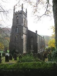
St. John the Baptist in the Wilderness Churchyard is located at Church Bank Lane Cragg Vale, Metropolitan Borough of Calderdale ,West Yorkshire , HX7 5TFEngland.
-
St. John the Baptist in the Wilderness Churchyard cemetery's updated grave count on graveviews.com?
0 memorials
-
Where are the coordinates of the St. John the Baptist in the Wilderness Churchyard?
Latitude: 53.7052900
Longitude: -2.0007900
Nearby Cemetories:
1. Mytholmroyd Methodist Chapelyard
Mytholmroyd, Metropolitan Borough of Calderdale, England
Coordinate: 53.7277100, -1.9834200
2. Steep Lane Baptist Chapel Cemetery
Sowerby Bridge, Metropolitan Borough of Calderdale, England
Coordinate: 53.7092690, -1.9573450
3. St. Michael's Churchyard
Mytholmroyd, Metropolitan Borough of Calderdale, England
Coordinate: 53.7300780, -1.9814340
4. St. Mary's Churchyard
Sowerby Bridge, Metropolitan Borough of Calderdale, England
Coordinate: 53.6912230, -1.9580330
5. Sowerby Congregational Church Graveyard
Sowerby Bridge, Metropolitan Borough of Calderdale, England
Coordinate: 53.7059486, -1.9426959
6. Mill Bank Wesleyan Methodist Graveyard
Sowerby Bridge, Metropolitan Borough of Calderdale, England
Coordinate: 53.6887540, -1.9476840
7. Friends Burial Ground
Mankinholes, Metropolitan Borough of Calderdale, England
Coordinate: 53.7092300, -2.0628900
8. Luddenden Foot Congregational Churchyard
Luddenden, Metropolitan Borough of Calderdale, England
Coordinate: 53.7166300, -1.9408500
9. Luddenden Foot United Methodist Free Chapel
Luddenden, Metropolitan Borough of Calderdale, England
Coordinate: 53.7213642, -1.9436207
10. Mankinholes Methodist Chapelyard
Mankinholes, Metropolitan Borough of Calderdale, England
Coordinate: 53.7100300, -2.0636700
11. St. Peter's Churchyard
Sowerby Bridge, Metropolitan Borough of Calderdale, England
Coordinate: 53.7052590, -1.9369570
12. Eastwood Congregational Chapelyard
Todmorden, Metropolitan Borough of Calderdale, England
Coordinate: 53.7255900, -2.0549500
13. Birchcliffe Baptist Cemetery
Hebden Bridge, Metropolitan Borough of Calderdale, England
Coordinate: 53.7433500, -2.0074100
14. Lumbutts United Free Methodist Chapelyard
Lumbutts, Metropolitan Borough of Calderdale, England
Coordinate: 53.7068000, -2.0655000
15. Cross Lanes Methodist Church Graveyard
Hebden Bridge, Metropolitan Borough of Calderdale, England
Coordinate: 53.7446150, -2.0161320
16. St James the Great Churchyard
Mytholm, Metropolitan Borough of Calderdale, England
Coordinate: 53.7430890, -2.0251210
17. St. James the Great
Hebden Bridge, Metropolitan Borough of Calderdale, England
Coordinate: 53.7431270, -2.0250690
18. Ebenezer Methodist Chapelyard
Soyland Town, Metropolitan Borough of Calderdale, England
Coordinate: 53.6804790, -1.9446120
19. Mount Olivet Baptist Chapelyard
Hebden Bridge, Metropolitan Borough of Calderdale, England
Coordinate: 53.7357600, -2.0494500
20. Butts Green Baptist Chapelyard
Warley, Metropolitan Borough of Calderdale, England
Coordinate: 53.7214360, -1.9340810
21. St. Thomas the Apostle Churchyard
Heptonstall, Metropolitan Borough of Calderdale, England
Coordinate: 53.7483840, -2.0220110
22. St Mary Churchyard
Luddenden, Metropolitan Borough of Calderdale, England
Coordinate: 53.7322500, -1.9387700
23. Luddenden Cemetery
Luddenden, Metropolitan Borough of Calderdale, England
Coordinate: 53.7329100, -1.9389600
24. Heptonstall Methodist Chapelyard
Heptonstall, Metropolitan Borough of Calderdale, England
Coordinate: 53.7497300, -2.0200000