
| Memorials | : | 127 |
| Location | : | Sparks, Cherry County, USA |
| Coordinate | : | 42.9399986, -100.2463989 |
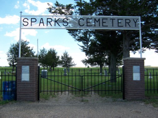
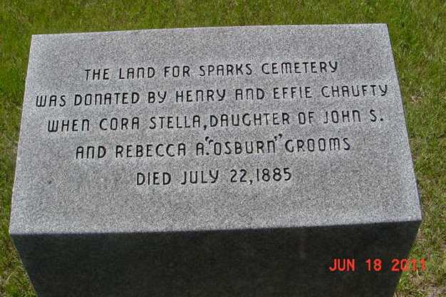
| Description | : | The Sparks Cemetery is located 18.5 miles east of Valentine on Highway #12 or 1 mile east of Sparks, Nebraska on Section 10, Range 25, Township 34. The cemetery was established in 1885 from a donation of land by pioneer Henry Chaufty who was an original homesteader when Stella Grooms, daughter of John S and Rebecca "Annie" Grooms died on July 22, 1885. The west side is the earliest part of the cemetery. In 1967 the gate and fence along the highway was added. The early records of the cemetery were destroyed in a fire. There are burials without markers or records. The Friends... Read More |
frequently asked questions (FAQ):
-
Where is Sparks Cemetery?
Sparks Cemetery is located at Sparks, Cherry County ,Nebraska ,USA.
-
Sparks Cemetery cemetery's updated grave count on graveviews.com?
127 memorials
-
Where are the coordinates of the Sparks Cemetery?
Latitude: 42.9399986
Longitude: -100.2463989
Nearby Cemetories:
1. Kewanee Cemetery
Cherry County, USA
Coordinate: 42.9332020, -100.3366500
2. Saint Joseph Cemetery
Kewanee, Cherry County, USA
Coordinate: 42.9700000, -100.3373500
3. Norden Cemetery
Norden, Keya Paha County, USA
Coordinate: 42.8685837, -100.0950851
4. Norden West Cemetery
Keya Paha County, USA
Coordinate: 42.8685989, -100.0947037
5. Linden Pioneer Cemetery
Tripp County, USA
Coordinate: 43.0607986, -100.1258011
6. Pleasant Dale Cemetery
Keya Paha County, USA
Coordinate: 42.8494000, -100.0608000
7. Fort Niobrara Post Cemetery
Valentine, Cherry County, USA
Coordinate: 42.8885630, -100.4779260
8. Lost Creek Cemetery
Keya Paha County, USA
Coordinate: 42.9486008, -99.9646988
9. Taylor Cemetery
Thatcher, Cherry County, USA
Coordinate: 42.8131000, -100.4832500
10. Mount Hope Cemetery
Valentine, Cherry County, USA
Coordinate: 42.8669014, -100.5350037
11. Richland Harmony Cemetery
Valentine, Cherry County, USA
Coordinate: 42.9763985, -100.5736008
12. Minnechaduza Cemetery
Valentine, Cherry County, USA
Coordinate: 42.8731003, -100.5674973
13. Ascension Chapel Cemetery
Tripp County, USA
Coordinate: 43.0656400, -99.9211800
14. Union Cemetery
Keya Paha County, USA
Coordinate: 42.8091780, -99.9043730
15. Jerusalem Cemetery
Tripp County, USA
Coordinate: 43.2341995, -100.1856003
16. Mount Hope Cemetery
Wood Lake, Cherry County, USA
Coordinate: 42.6372920, -100.2330200
17. Saint Boniface Catholic Cemetery
Clearfield, Tripp County, USA
Coordinate: 43.2130000, -100.0450000
18. Carroll Cemetery
Olsonville, Todd County, USA
Coordinate: 43.1371300, -100.6085100
19. Saint Agnes Cemetery
Todd County, USA
Coordinate: 43.0372009, -100.6952972
20. Crookston Cemetery
Cherry County, USA
Coordinate: 42.9267970, -100.7313580
21. Congregational Cemetery
Tripp County, USA
Coordinate: 43.1116982, -99.8199997
22. West Enterprise Cemetery
Burton, Keya Paha County, USA
Coordinate: 42.9785995, -99.7478027
23. Highland Grove Cemetery
Ainsworth, Brown County, USA
Coordinate: 42.6954000, -99.8530000
24. Lakeview Cemetery
Todd County, USA
Coordinate: 43.0746994, -100.7300034