
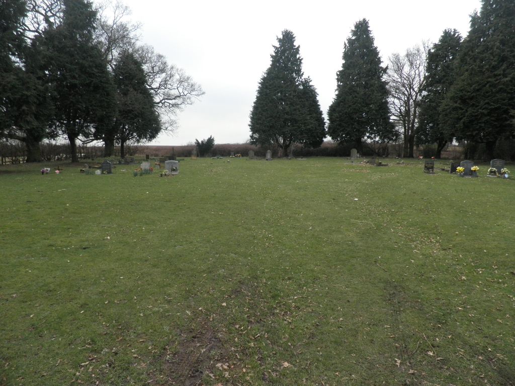
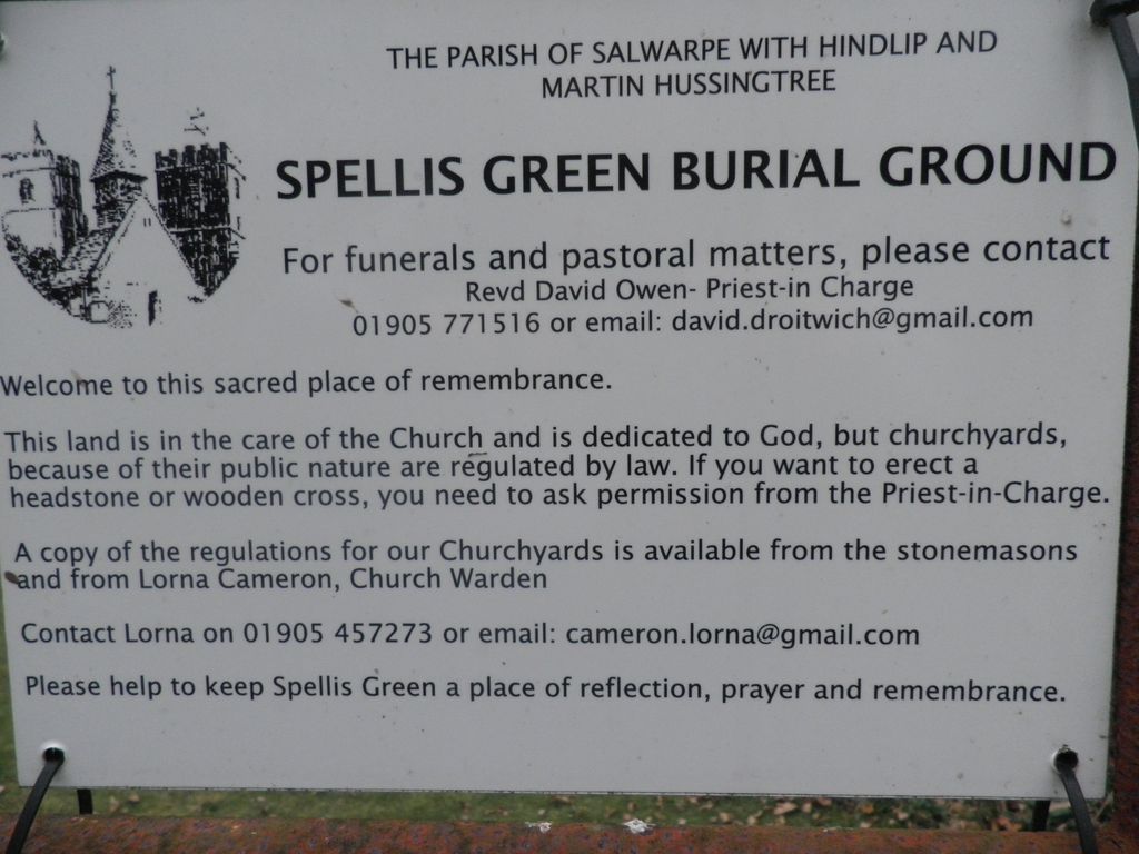
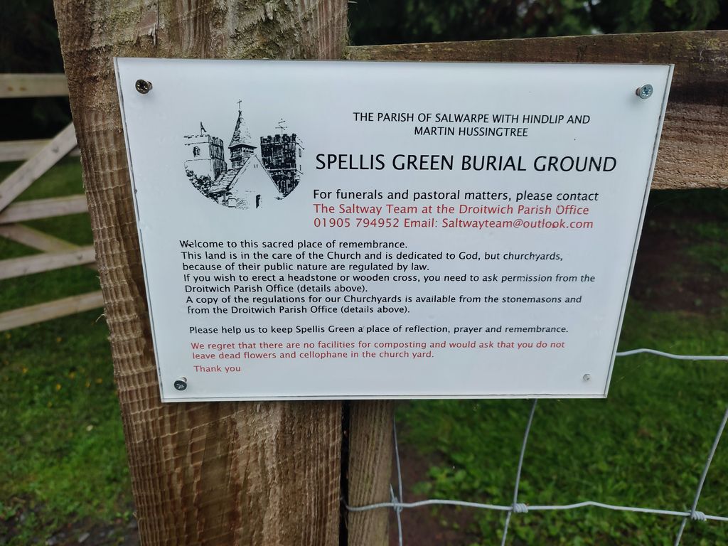
| Memorials | : | 0 |
| Location | : | Fernhill Heath, Wychavon District, England |
| Coordinate | : | 52.2257240, -2.1949210 |
frequently asked questions (FAQ):
-
Where is Spellis Green Burial Ground?
Spellis Green Burial Ground is located at Fernhill Heath, Wychavon District ,Worcestershire ,England.
-
Spellis Green Burial Ground cemetery's updated grave count on graveviews.com?
0 memorials
-
Where are the coordinates of the Spellis Green Burial Ground?
Latitude: 52.2257240
Longitude: -2.1949210
Nearby Cemetories:
1. St. James Churchyard
Hindlip, Wychavon District, England
Coordinate: 52.2254059, -2.1767057
2. St Michael and All Angels Churchyard
Martin Hussingtree, Wychavon District, England
Coordinate: 52.2364000, -2.1819030
3. St. John the Baptist Churchyard
Claines, Wychavon District, England
Coordinate: 52.2273145, -2.2184514
4. Astwood Cemetery
Worcester, City of Worcester, England
Coordinate: 52.2078630, -2.2050980
5. St Nicholas Churchyard
Warndon, City of Worcester, England
Coordinate: 52.2100577, -2.1657159
6. St. Stephens Churchyard
Worcester, City of Worcester, England
Coordinate: 52.2098500, -2.2254300
7. St. George's Churchyard
Worcester, City of Worcester, England
Coordinate: 52.2038940, -2.2246274
8. St. Michael's Churchyard
Salwarpe, Wychavon District, England
Coordinate: 52.2567600, -2.1850900
9. St Oswald's Hospital Churchyard
Worcester, City of Worcester, England
Coordinate: 52.1989700, -2.2232400
10. St Bartholomew Churchyard
Grimley, Malvern Hills District, England
Coordinate: 52.2440700, -2.2412420
11. St Peter ad Vincula Churchyard
Tibberton, Wychavon District, England
Coordinate: 52.2109700, -2.1444900
12. Black Friars of Worcester
Worcester, City of Worcester, England
Coordinate: 52.1962970, -2.2244990
13. St Philip and St James Churchyard
Hallow, Malvern Hills District, England
Coordinate: 52.2192900, -2.2524500
14. St Martin In The Cornmarket
Worcester, City of Worcester, England
Coordinate: 52.1930500, -2.2189300
15. St Paul Churchyard
Worcester, City of Worcester, England
Coordinate: 52.1917400, -2.2156500
16. Saint Swithun Churchyard
Worcester, City of Worcester, England
Coordinate: 52.1925300, -2.2204000
17. Greyfriars
Worcester, City of Worcester, England
Coordinate: 52.1905400, -2.2187800
18. All Saints Churchyard
Worcester, City of Worcester, England
Coordinate: 52.1919400, -2.2240200
19. Saint Andrew Churchyard
Worcester, City of Worcester, England
Coordinate: 52.1911300, -2.2224300
20. St Helen's Church
Worcester, City of Worcester, England
Coordinate: 52.1903000, -2.2209900
21. Saint Alban Church
Worcester, City of Worcester, England
Coordinate: 52.1904262, -2.2218995
22. Worcester Cathedral
Worcester, City of Worcester, England
Coordinate: 52.1887270, -2.2208070
23. St. Peter the Great Churchyard
Worcester, City of Worcester, England
Coordinate: 52.1878260, -2.2185430
24. Sacred Heart & Saint Catherine Churchyard
Droitwich Spa, Wychavon District, England
Coordinate: 52.2588639, -2.1551795