
| Memorials | : | 0 |
| Location | : | Worcester, City of Worcester, England |
| Coordinate | : | 52.1904262, -2.2218995 |
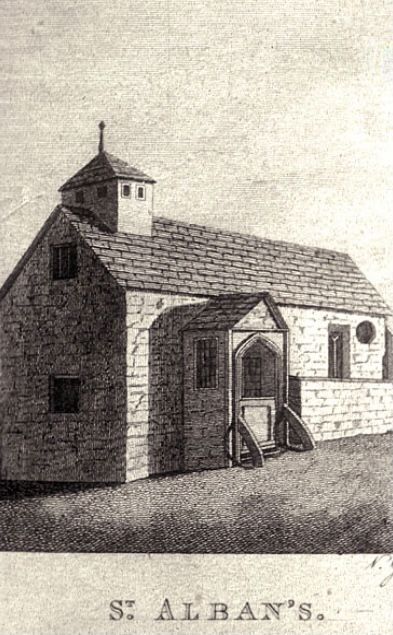
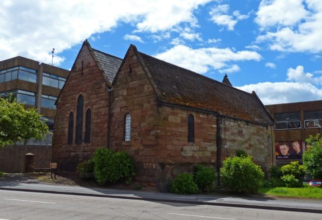
| Description | : | Saint Alban's Church is an old Norman church and is the oldest church in city center of Worcester, located between Deansway and Worcester College of Technology. Declared redundant as a church and cemetery in 1976, with no information on the burials that were located there, although records are still available. The church was repaired with modern upgrades and converted into a homeless center called Maggs Day Centre. From the website Historicalengland, "the Church of St. Alban survives comparatively well and forms an integral part of a nationally important abbey and medieval town. The church was established by the 6th... Read More |
frequently asked questions (FAQ):
-
Where is Saint Alban Church?
Saint Alban Church is located at Worcester, City of Worcester ,Worcestershire ,England.
-
Saint Alban Church cemetery's updated grave count on graveviews.com?
0 memorials
-
Where are the coordinates of the Saint Alban Church?
Latitude: 52.1904262
Longitude: -2.2218995
Nearby Cemetories:
1. St Helen's Church
Worcester, City of Worcester, England
Coordinate: 52.1903000, -2.2209900
2. Saint Andrew Churchyard
Worcester, City of Worcester, England
Coordinate: 52.1911300, -2.2224300
3. Worcester Cathedral
Worcester, City of Worcester, England
Coordinate: 52.1887270, -2.2208070
4. Greyfriars
Worcester, City of Worcester, England
Coordinate: 52.1905400, -2.2187800
5. All Saints Churchyard
Worcester, City of Worcester, England
Coordinate: 52.1919400, -2.2240200
6. Saint Swithun Churchyard
Worcester, City of Worcester, England
Coordinate: 52.1925300, -2.2204000
7. St Martin In The Cornmarket
Worcester, City of Worcester, England
Coordinate: 52.1930500, -2.2189300
8. St. Peter the Great Churchyard
Worcester, City of Worcester, England
Coordinate: 52.1878260, -2.2185430
9. St Paul Churchyard
Worcester, City of Worcester, England
Coordinate: 52.1917400, -2.2156500
10. Black Friars of Worcester
Worcester, City of Worcester, England
Coordinate: 52.1962970, -2.2244990
11. St. Clement's Churchyard
Worcester, City of Worcester, England
Coordinate: 52.1906579, -2.2341371
12. St Johns Bedwardine
Worcester, City of Worcester, England
Coordinate: 52.1882200, -2.2352000
13. St Oswald's Hospital Churchyard
Worcester, City of Worcester, England
Coordinate: 52.1989700, -2.2232400
14. Saint John's Cemetery
Worcester, City of Worcester, England
Coordinate: 52.1894670, -2.2436270
15. St. George's Churchyard
Worcester, City of Worcester, England
Coordinate: 52.2038940, -2.2246274
16. St. Stephens Churchyard
Worcester, City of Worcester, England
Coordinate: 52.2098500, -2.2254300
17. Astwood Cemetery
Worcester, City of Worcester, England
Coordinate: 52.2078630, -2.2050980
18. St. Philip and James Churchyard
Whittington, Wychavon District, England
Coordinate: 52.1741600, -2.1821800
19. St Peter's Church Burial Ground
Powick, Malvern Hills District, England
Coordinate: 52.1613890, -2.2432490
20. St Thomas Churchyard
Rushwick, Malvern Hills District, England
Coordinate: 52.1903870, -2.2751750
21. St Philip and St James Churchyard
Hallow, Malvern Hills District, England
Coordinate: 52.2192900, -2.2524500
22. St. John the Baptist Churchyard
Claines, Wychavon District, England
Coordinate: 52.2273145, -2.2184514
23. Elgar Birthplace Museum
Lower Broadheath, Malvern Hills District, England
Coordinate: 52.1989600, -2.2827000
24. Spellis Green Burial Ground
Fernhill Heath, Wychavon District, England
Coordinate: 52.2257240, -2.1949210