
| Memorials | : | 0 |
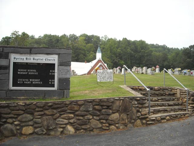
| Location | : | Canton, Haywood County, USA |
| Coordinate | : | 35.4864610, -82.8501960 |
| Description | : | Located in the Center Pigeon area of Haywood County. From the Waynesville Courthouse, follow US 23S (Main Street) to its intersection with US 276S (Pigeon Street). Proceed south on US 276 until it intersection with NC 110 at the stop light in Bethel. Go north on NC 110 (left) for 1.1 miles and turn right on Murray Road (SR 1871). Continue for 1.9 miles to Spring Hill Baptist Church which is located on the right side of the road. |
frequently asked questions (FAQ):
-
Where is Spring Hill Baptist Church Cemetery?
Spring Hill Baptist Church Cemetery is located at 1918 Murray Road Canton, Haywood County ,North Carolina , 28716USA.
-
Spring Hill Baptist Church Cemetery cemetery's updated grave count on graveviews.com?
0 memorials
-
Where are the coordinates of the Spring Hill Baptist Church Cemetery?
Latitude: 35.4864610
Longitude: -82.8501960
Nearby Cemetories:
1. Longs Community Cemetery
Canton, Haywood County, USA
Coordinate: 35.4878650, -82.8561950
2. Center Pigeon Baptist Church Cemetery
Canton, Haywood County, USA
Coordinate: 35.5053180, -82.8581450
3. Sunny Point Baptist Church Cemetery
Haywood County, USA
Coordinate: 35.5065900, -82.8369100
4. Piney Grove Methodist Church Cemetery
Canton, Haywood County, USA
Coordinate: 35.5108500, -82.8667000
5. Mount Zion Baptist Church Cemetery
Canton, Haywood County, USA
Coordinate: 35.4535530, -82.8707050
6. Bethel Community Cemetery
Bethel, Haywood County, USA
Coordinate: 35.4714360, -82.8928540
7. Morning Star United Methodist Church Cemetery
Canton, Haywood County, USA
Coordinate: 35.5134720, -82.8145730
8. Gibsontown Cemetery
Gibsontown, Haywood County, USA
Coordinate: 35.5252500, -82.8249600
9. Locust Field Cemetery
Canton, Haywood County, USA
Coordinate: 35.5294810, -82.8340490
10. Saint Andrews on the Hill Episcopal Church Garden
Canton, Haywood County, USA
Coordinate: 35.5314230, -82.8357430
11. Smathers Cemetery
West Canton, Haywood County, USA
Coordinate: 35.5344009, -82.8503036
12. West Canton-Phillipsville Community Cemetery
West Canton, Haywood County, USA
Coordinate: 35.5351900, -82.8510300
13. Haynes Family Cemetery
Canton, Haywood County, USA
Coordinate: 35.5322200, -82.8847600
14. Crawford-Ray Memorial Gardens
Clyde, Haywood County, USA
Coordinate: 35.5289001, -82.8917007
15. Patton Cemetery
West Canton, Haywood County, USA
Coordinate: 35.5381012, -82.8707962
16. Bon-A-Venture Cemetery Old
West Canton, Haywood County, USA
Coordinate: 35.5335999, -82.8835983
17. New Cruso Cemetery
Canton, Haywood County, USA
Coordinate: 35.4402000, -82.8124000
18. Gwyn Cemetery
Big East Fork, Haywood County, USA
Coordinate: 35.4398900, -82.8129300
19. Quinn Cemetery
Haywood County, USA
Coordinate: 35.4392014, -82.8125000
20. Pleasant Hill Cemetery
Clyde, Haywood County, USA
Coordinate: 35.5285988, -82.9036026
21. Riverside Cemetery
Canton, Haywood County, USA
Coordinate: 35.4478550, -82.9140920
22. Justice-Red Hill School Cemetery
Canton, Haywood County, USA
Coordinate: 35.5369930, -82.7899970
23. Old Thickety Cemetery
Clyde, Haywood County, USA
Coordinate: 35.5537454, -82.8769841
24. North Canton Community Cemetery
Canton, Haywood County, USA
Coordinate: 35.5583000, -82.8388977