
| Memorials | : | 0 |
| Location | : | Melcombe Horsey, West Dorset District, England |
| Coordinate | : | 50.8177370, -2.3238320 |
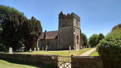
| Description | : | Melcombe Horsey is a civil parish in the county of Dorset in South West England. It contains the small settlements of Melcombe Bingham, Bingham's Melcombe and Higher Melcombe, the last being the site of the deserted village of Melcombe Horsey. The church of St. Andrew, Melcombe Horsey can be found next to Bingham's Melcombe house. It is mostly fourteenth century and is built of stone and flint. The remains of a deserted medieval village lie to the south. |
frequently asked questions (FAQ):
-
Where is St Andrew's Church?
St Andrew's Church is located at Melcombe Horsey, West Dorset District ,Dorset ,England.
-
St Andrew's Church cemetery's updated grave count on graveviews.com?
0 memorials
-
Where are the coordinates of the St Andrew's Church?
Latitude: 50.8177370
Longitude: -2.3238320
Nearby Cemetories:
1. All Saints Churchyard
Hilton, North Dorset District, England
Coordinate: 50.8258900, -2.3103000
2. St Martin
Cheselbourne, West Dorset District, England
Coordinate: 50.8001920, -2.3413970
3. Milton Abbey
Milton Abbas, North Dorset District, England
Coordinate: 50.8198430, -2.2876720
4. St James' Churchyard
Milton Abbas, North Dorset District, England
Coordinate: 50.8152850, -2.2760600
5. All Saints Churchyard
Dewlish, West Dorset District, England
Coordinate: 50.7827870, -2.3202580
6. All Saints Churchyard
Stoke Wake, North Dorset District, England
Coordinate: 50.8569100, -2.3358050
7. St. Mary's Church
Woolland, North Dorset District, England
Coordinate: 50.8618600, -2.3194300
8. St. Andrew's Churchyard
Winterborne Houghton, North Dorset District, England
Coordinate: 50.8388922, -2.2565686
9. St Peter and St Paul Churchyard
Mappowder, North Dorset District, England
Coordinate: 50.8527740, -2.3773230
10. St Andrew Churchyard
Milborne St Andrew, North Dorset District, England
Coordinate: 50.7757960, -2.2833520
11. St John The Baptist
Piddletrenthide, West Dorset District, England
Coordinate: 50.8192530, -2.4021230
12. St Eustace Churchyard
Ibberton, North Dorset District, England
Coordinate: 50.8672550, -2.3004360
13. St. Mary and St. James Churchyard
Hazelbury Bryan, North Dorset District, England
Coordinate: 50.8736000, -2.3520000
14. St Mary's Churchyard
Winterborne Whitechurch, North Dorset District, England
Coordinate: 50.8004000, -2.2340000
15. St. Mary's Churchyard
Winterborne Stickland, North Dorset District, England
Coordinate: 50.8406500, -2.2361600
16. All Saints Churchyard
Piddletrenthide, West Dorset District, England
Coordinate: 50.8053720, -2.4242110
17. St. Mary the Virgin Churchyard
Turnworth, North Dorset District, England
Coordinate: 50.8688840, -2.2576510
18. Alton Pancras Cemetery
Alton Pancras, West Dorset District, England
Coordinate: 50.8203710, -2.4289390
19. St Mary the Virgin Churchyard
Piddlehinton, West Dorset District, England
Coordinate: 50.7732980, -2.4045680
20. St. Mary the Virgin Churchyard
Puddletown, West Dorset District, England
Coordinate: 50.7484670, -2.3434700
21. St Aldhelm Churchyard
Belchalwell, North Dorset District, England
Coordinate: 50.8873030, -2.2964750
22. St. Thomas A' Beckett Churchyard
Pulham, North Dorset District, England
Coordinate: 50.8753720, -2.4111670
23. All Saints Church, Fifehead Neville
Fifehead Neville, North Dorset District, England
Coordinate: 50.8980180, -2.3312380
24. All Saints
Fifehead Neville, North Dorset District, England
Coordinate: 50.8980320, -2.3311970